Area Overview for CB21 4DH
Photos of CB21 4DH
Area Information
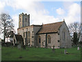
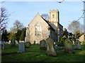
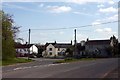
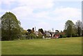
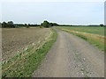
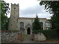
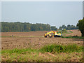
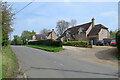
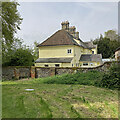
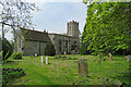
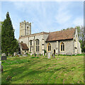
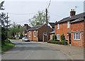
Living in CB21 4DH means being part of a small, tightly knit residential cluster in South Cambridgeshire, just 14 miles south-east of Cambridge. With a population of 1,404 and a density of 47 people per square kilometre, this area blends rural charm with accessible connectivity. The postcode covers a cluster of homes nestled in rolling countryside, near the Suffolk and Essex borders, with the village of Horseheath at its heart. This village, though small, retains traditional English village features: a village green, historic church, pub, cricket team, and village hall. Its proximity to Cambridge and Haverhill means residents can enjoy urban amenities while retaining a peaceful, community-focused lifestyle. The area’s history is steeped in medieval roots, with Neolithic and Roman heritage adding layers to its character. For those seeking a balance between tranquillity and practicality, CB21 4DH offers a quiet, self-contained environment with a strong sense of local identity.
- Area Type
- Postcode
- Area Size
- Not available
- Population
- 1404
- Population Density
- 47 people/km²
CB21 4DH is primarily an owner-occupied area, with 75% of homes owned by residents rather than rented. The accommodation type is predominantly houses, reflecting a low-density, suburban or rural housing stock. This contrasts with areas dominated by flats or apartments, suggesting a market where larger properties are the norm. Given the small size of the postcode and its focus on houses, the property market here is likely limited in scale, with fewer new developments. Buyers should consider that the immediate surroundings may offer more options, particularly in nearby villages or towns like Haverhill or Cambridge. The high home ownership rate indicates a stable market with long-term residents, which can be reassuring for buyers seeking a settled community. However, the limited number of properties means competition may be fierce, and buyers may need to look beyond the immediate postcode for more choices.
House Prices in CB21 4DH
No properties found in this postcode.
Energy Efficiency in CB21 4DH
The lifestyle in CB21 4DH is shaped by its rural setting and small-scale amenities. Within practical reach are five retail outlets, including Sainsburys in Haverhill, Co-op in Linton, and Tesco in Haverhill, providing everyday shopping needs. The village of Horseheath itself offers a pub, cricket team, and village hall, fostering a sense of community through local events and social activities. The area’s rolling countryside and traditional village features, such as a village green and historic church, contribute to a tranquil, low-stress environment. While larger retail and leisure options are in nearby towns, the immediate vicinity supports a self-contained lifestyle with access to essential services. The presence of a cricket team and village hall highlights opportunities for recreation and social engagement, reinforcing the area’s appeal for those valuing close-knit communities and outdoor living.
Amenities
Schools
The schools nearest to CB21 4DH include Castle Camps Church of England (Controlled) Primary School, a primary school with an Ofsted rating of ‘good’, and Glebe House, a special school. The presence of both a primary school and a special school suggests a mix of educational provision tailored to different needs. Families with young children benefit from the primary school’s proximity, while those requiring specialist education can access Glebe House. The ‘good’ Ofsted rating for the primary school indicates a reliable standard of teaching and facilities. However, the absence of secondary schools within the area means students may need to commute to nearby towns like Cambridge or Haverhill for higher education. This mix of school types supports a range of family requirements but underscores the importance of proximity to larger educational hubs for secondary schooling.
| Rank | School | Type | Entry gender | Ages |
|---|
Explore more schools in this area
Go to Schools tabDemographics
The population of CB21 4DH is predominantly adults aged 30–64, with a median age of 47. This suggests a mature, stable community, likely centred around family homes and long-term residency. Home ownership is high, at 75%, with the majority of properties being houses rather than flats or apartments. The predominant ethnic group is White, reflecting the area’s rural, traditional character. The low population density of 47 people per square kilometre indicates a spread-out, low-rise residential pattern, typical of small villages. This demographic profile implies a community focused on established living, with fewer transient residents. The absence of specific data on deprivation or diversity means the area’s social dynamics are likely shaped by long-standing local ties rather than rapid change. For homebuyers, this suggests a market where properties are likely to be family-owned and well-maintained, with a strong emphasis on community cohesion.
Household Size
Accommodation Type
Tenure
Ethnic Group
Religion
Household Composition
Age
Household Deprivation
NS-SEC
Explore more demographic insights in this area
Go to Demographics tabPlanning
Planning Constraints
- Flood RiskPremium
- Ramsar Wetland SitesPremium
- Area of Outstanding Natural BeautyPremium
- Protected Nature ReservePremium
- Protected WoodlandPremium