Area Overview for CB2 5UG
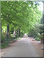
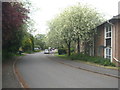
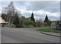
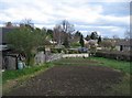
Photos of CB2 5UG


Area Information
Living in CB2 5UG offers a settled rural lifestyle on the edge of Cambridge, situated within the Great Shelford civil parish. This specific postcode covers a small residential cluster with a population of 1741, providing a quiet environment that still maintains close links to the city. The area is defined by its historic settlement patterns, evolving from early Neolithic and Roman origins around the River Cam to a thriving suburban commuter village today. Residents benefit from a location approximately 4 miles south of Cambridge, a distance that balances tranquility with city access. The demographic profile suggests a stable community where adults aged 30 to 64 form the most common age group, indicating families and established households dominate the scene. With a population density of 1335 people per square kilometre, the locality feels open yet connected. The majority of residents live in houses, reflecting a preference for traditional family accommodation over flats or smaller city dwellings. While the area has grown significantly since the mid-19th century, with the population increasing to over 4000 by 2011, the current figure of 1741 suggests a specific, possibly updated snapshot of a tightly knit neighbourhood that values its historical roots and proximity to the River Cam.
- Area Type
- Postcode
- Area Size
- Not available
- Population
- 1741
- Population Density
- 1335 people/km²
The property market in CB2 5UG is characterised by a residential stock dominated by houses. With 44% of residents owning their homes, the area leans heavily towards owner-occupied households rather than a letting market. This high rate of ownership suggests that properties in this postcode cluster are often passed down or purchased with the intent of staying for generations. The housing stock is primarily composed of houses, a fact that reflects the area's evolution from a medieval village to a suburban commuter location. Buyers looking at homes in CB2 5UG should expect a environment where established family properties are the norm. The accommodation type aligns with the demographic reality of a median age of 47 years, where larger family homes suit the local population. The area was once the second most densely populated parish in Cambridgeshire in the 1860s, yet it retains a village feel. While the total population in the wider parish reached 4,233 in 2011, the specific cluster at CB2 5UG holds 1,741 residents, indicating a concentrated living area. The market thus serves buyers seeking permanent homes in a historic setting near Great Shelford Conservation Area with its High Street and historic core.
House Prices in CB2 5UG
No properties found in this postcode.
Energy Efficiency in CB2 5UG
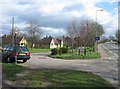
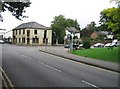
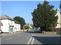
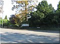
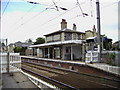
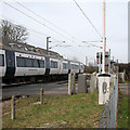
Daily life in CB2 5UG offers convenient access to essential amenities within practical reach. Residents have five retail options nearby, including Co-op Great, Tesco Great, and Spar, ensuring easy access to groceries and daily necessities. Five rail stations serve the immediate area, with Shelford Railway Station being the primary hub for travel to Cambridge and beyond. Travelers can also utilize Whittlesford Parkway Railway Station and Foxton Railway Station for additional connectivity. For those preferring air travel, two airports, both identified as Cambridge Airport, are within reach. The area's lifestyle is deeply rooted in its landscape, bisected by the River Cam. This natural feature offers scenic walking opportunities and defines the local character. The High Street acts as a central point for local activity. The Great Shelford Conservation Area preserves the historic core around High Green and the church, adding cultural value to the living experience. With a population density of 1335 people per square kilometre, the area feels lived-in but not overcrowded. The combination of named retail outlets like the Co-op and the presence of multiple transport hubs creates a balanced lifestyle that blends village convenience with regional accessibility.
Amenities
Schools
| Rank | School | Type | Entry gender | Ages |
|---|
Explore more schools in this area
Go to Schools tabDemographics
The community character of CB2 5UG is defined by a mature demographic profile and strong home ownership. The median age stands at 47 years, confirming that adults between 30 and 64 years constitute the most common age range for residents. This age distribution typically signals an area where long-term families and professionals have established their roots. Home ownership levels are high, with 44% of residents owning their homes outright. This figure indicates a significant portion of the population has settled permanently rather than renting. The primary accommodation type consists of houses, which aligns with the needs of the older age group and families. The predominant ethnic group is White, reflecting the established nature of the settlement which dates back to the Saxon and medieval periods. Great Shelford was listed as Britain's twenty-second richest village in 2011, a statistic that helps explain the economic stability of the current residents. The area attracts Cambridge University academics and middle-class residents, contributing to a neighbourhood that values stability and tradition. These factors combine to create a demographic environment focused on long-term residence rather than short-term renting or transient living.
Household Size
Accommodation Type
Tenure
Ethnic Group
Religion
Household Composition
Age
Household Deprivation
NS-SEC
Explore more demographic insights in this area
Go to Demographics tabPlanning
Planning Constraints
- Flood RiskPremium
- Ramsar Wetland SitesPremium
- Area of Outstanding Natural BeautyPremium
- Protected Nature ReservePremium
- Protected WoodlandPremium