Area Overview for CB2 4XL
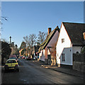
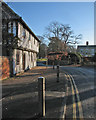
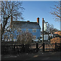
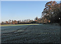
Photos of CB2 4XL
Area Information
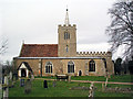
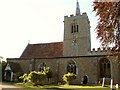
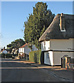
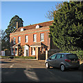
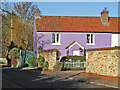
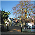
CB2 4XL is a small, tightly knit residential area nestled in the village of Whittlesford, South Cambridgeshire. With a population of just 1,237 people spread over a compact area, it retains a village-like character despite its proximity to Cambridge, around seven miles to the north. The postcode covers a cluster of homes, many of which are traditional properties reflecting the area’s historic roots. Whittlesford itself is a civil parish with a long history, dating back to the Domesday Book, and its medieval core remains visible in landmarks like St Andrew and St Mary Church, a Grade I listed building. Daily life here balances quiet rural charm with easy access to urban amenities. The village sits on the River Granta, with historic roads like the Icknield Way nearby. Residents benefit from a mix of local shops, rail connections, and a strong sense of community, making it appealing to those seeking a peaceful yet connected lifestyle.
- Area Type
- Postcode
- Area Size
- Not available
- Population
- 1237
- Population Density
- 396 people/km²
The property market in CB2 4XL is characterised by a high rate of home ownership (73%) and a predominance of houses over flats or apartments. This reflects the area’s traditional village structure, where larger properties are more common. Given the small population and limited land area, the housing stock is relatively constrained, making it a niche market for buyers seeking owner-occupied homes in a historic setting. The absence of high-rise or modern developments means properties here are likely to retain their character and value. For those considering the area, the focus on owner-occupation suggests a community of long-term residents rather than a transient rental market. Proximity to Cambridge may also influence property values, offering a balance between rural tranquillity and urban accessibility. Buyers should note that the limited supply of homes may mean competition for available properties.
House Prices in CB2 4XL
No properties found in this postcode.
Energy Efficiency in CB2 4XL
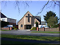
Living in CB2 4XL offers access to a range of local amenities within practical reach. Retail options include Spar, Co-op Sawston, and M&S Whittlesford Cambridge BP, providing everyday shopping needs. The village’s rail stations—Whittlesford Parkway, Shelford, and Great Chesterford—enhance connectivity for commuters. Parks and green spaces are also present, including King George’s Field, which adds to the area’s appeal for outdoor activities. The historic character of Whittlesford, with its listed church and conservation area, contributes to a distinct sense of place. While the data does not specify dining or leisure venues, the presence of retail and transport hubs suggests a lifestyle that blends local charm with practicality for daily living.
Amenities
Schools
The primary school nearest to CB2 4XL is William Westley Church of England VC Primary School, which has an Ofsted rating of “good.” This school serves the local community and is likely a key consideration for families moving to the area. The presence of a primary school with a solid rating indicates that the area supports children’s education, though no secondary schools are listed in the data. For families requiring a full range of educational options, proximity to Cambridge’s larger schools may be a factor. The single primary school suggests a smaller, close-knit educational environment, which can be both a benefit and a limitation depending on individual needs.
| Rank | School | Type | Entry gender | Ages |
|---|
Explore more schools in this area
Go to Schools tabDemographics
The population of CB2 4XL is 1,237, with a median age of 47, indicating a mature community. The majority of residents are adults aged 30–64, reflecting a stable demographic profile. Home ownership is high, with 73% of properties owner-occupied, suggesting a long-term resident base. Accommodation is predominantly houses, aligning with the area’s traditional village layout. The predominant ethnic group is White, with no specific data provided on other groups. This demographic profile implies a community focused on family living and stability, with fewer transient residents. The low population density of 396 people per km² further reinforces the area’s quiet, low-rise character. For buyers, this suggests a market skewed towards owner-occupied homes rather than rental properties, with demand likely driven by those seeking a settled lifestyle in a historic setting.
Household Size
Accommodation Type
Tenure
Ethnic Group
Religion
Household Composition
Age
Household Deprivation
NS-SEC
Explore more demographic insights in this area
Go to Demographics tabPlanning
Planning Constraints
- Flood RiskPremium
- Ramsar Wetland SitesPremium
- Area of Outstanding Natural BeautyPremium
- Protected Nature ReservePremium
- Protected WoodlandPremium