Area Overview for CB11 4NR
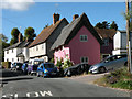
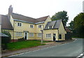
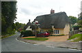
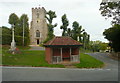
Photos of CB11 4NR
Area Information
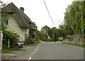
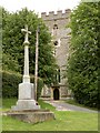
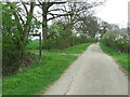
CB11 4NR is a small residential cluster situated within the broader character of Elmdon, a village and civil parish in the Uttlesford district of Essex. With a population of 1,563, this postcode area represents a quiet, settled community located five miles west of Saffron Walden and near the Cambridgeshire boundary. The land density here is low, averaging 46 people per square kilometre, which contributes to the rural, arable farming atmosphere that defines the region. This area retains an ancient parish history, encompassing 2,480 acres of light, chalky soil suitable for cereals, a landscape unchanged in its fundamental economic purpose since the Domesday Book. Living in CB11 4NR means engaging with a setting defined by its proximity to the River Cam and the historic Castle Hill motte, a Norman structure built around 1180. You are part of a close-knit environment where the presence of 1563 residents ensures a tranquil daily life without the congestion of larger urban centres. The specific postcode covers a cluster of homes that benefit from being surrounded by 2,480 acres of historically significant farmland. This location offers residents a balance between rural seclusion and accessibility to nearby services, making it a distinct choice for those seeking a life connected to the land yet reachable by modern transport links.
- Area Type
- Postcode
- Area Size
- Not available
- Population
- 1563
- Population Density
- 46 people/km²
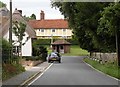
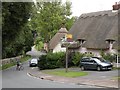
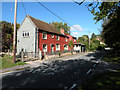
The property market in CB11 4NR is entirely defined by private houses, with no apartments or flats present in this specific postcode cluster. This is an almost certainly an owner-occupied area, where 76% of the 1,563 residents are homeowners. This high percentage of ownership indicates that the local housing market operates outside the typical rental dynamics found in newer estate developments. Buyers in CB11 4NR are looking for established housing stock rather than new-build communal living. The lack of a rental sector within this specific postcode suggests that properties here are held for generational living rather than short-term tenancy. This dynamic drives property values in line with the historical significance and rural charm of the location near the Cambridgeshire boundary. For those purchasing homes in CB11 4NR, the expectation is of a traditional house with a garden, situated within the 2,480 acres of the Elmdon civil parish. The market reflects a desire for permanence and independence, typical of a region where 76% of the population has already made this choice.
House Prices in CB11 4NR
No properties found in this postcode.
Energy Efficiency in CB11 4NR
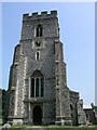
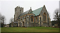
Residents of CB11 4NR enjoy practical access to essential amenities and local shopping opportunities. There are four rail stations within your practical reach, including Great Chesterford, Audley End, and Whittlesford Parkway, ensuring you can travel easily for work or leisure. For daily necessities, five notable retail outlets are situated nearby, with Cook Saffron, Waitrose Saffron, and Tesco Saffron providing a range of food and household goods. These supermarkets are key destinations for residents within the Elmdon parish, eliminating the need to travel long distances for basic groceries. The lifestyle in this area is shaped by its rural setting but supported by convenient modern services. You can balance a quiet life near the Cambridgeshire boundary with trips to local shops and dining at venues like Cook Saffron. The area is characterised by its historical sites, such as the Grade II* listed church of St Nicholas and the moated manor house Pigots, which offer a connection to the past while you shop at Waitrose Saffron today. This blend of history and modern convenience defines the living experience.
Amenities
Schools
There is one primary school located near CB11 4NR, the Chrishall Holy Trinity and St Nicholas CofE (Aided) Primary School and Pre-School. This institution holds a Good Ofsted rating, reflecting its quality of education and pastoral care. As the nearest educational facility to this postcode, it serves the local community of children within the immediate vicinity of Elmdon. The presence of a Church of England Aided school indicates a specific faith-based curriculum alongside the standard English National Curriculum requirements. For families seeking schools near CB11 4NR, this primary school is the only option explicitly listed within the provided data for the area. It is an essential resource for the 1563 residents living in this small cluster. The school's status as a primary institution means it caters to children from an early age up to the entry point for secondary education. Parental choice is limited to this single named institution for primary schooling prospects in this specific postcode, while children who require secondary education would need to travel further given the rural location near Saffron Walden and the Cambridgeshire boundary.
| Rank | School | Type | Entry gender | Ages |
|---|
Explore more schools in this area
Go to Schools tabDemographics
The community in CB11 4NR is predominantly composed of adults between the ages of 30 and 64 years. This age range constitutes the most common demographic group within the 1,563 residents of the area. Consequently, the neighbourhood attracts a settled population with established lives rather than a transient commuter workforce or a high concentration of young families. Home ownership is the prevailing housing tenure, with 76% of residents owning their properties outright or with a mortgage. This high ownership rate suggests a community of long-term residents invested in their immediate surroundings. The accommodation type is exclusively houses, reflecting the rural nature of this 46 people per square kilometre cluster. There are no apartment blocks or flats within this specific postcode, reinforcing the traditional character of the settlement. The predominant ethnic group is White, which aligns with the generally rural and historically established profile of Uttlesford. This steady demographic profile indicates a stable environment where residents know their neighbours and local history is a shared heritage. You will find a community where decision-making is likely influenced by the preferences of a mature, property-owning population.
Household Size
Accommodation Type
Tenure
Ethnic Group
Religion
Household Composition
Age
Household Deprivation
NS-SEC
Explore more demographic insights in this area
Go to Demographics tabPlanning
Planning Constraints
- Flood RiskPremium
- Ramsar Wetland SitesPremium
- Area of Outstanding Natural BeautyPremium
- Protected Nature ReservePremium
- Protected WoodlandPremium