Area Overview for CB10 2UU
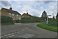
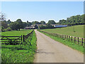
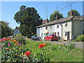
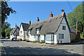
Photos of CB10 2UU
Area Information
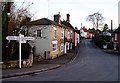
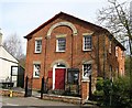
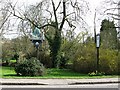
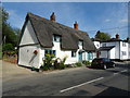
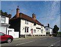
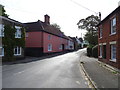
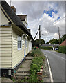
Ashdon, identified by the postcode CB10 2UU, embodies a quiet village life centred on farming heritage and historic charm. This specific cluster within the parish serves approximately 1,750 residents across a landscape defined by ancient hillsides and wooded valleys. The settlement historically encompassed hamlets such as Steventon End and Little Bartlow, maintaining its rural identity through centuries of history from Roman times to the present day. You will find yourselves situated in a community that combines an ancient hilltop area around All Saints Church with a larger valley settlement dating back to the 13th and 14th centuries. Daily life here revolves around essential local services and a tight-knit environment rather than a bustling commercial hub. The area features notable landmarks like the Guildhall of St. Mary and the Rose & Crown pub, offering proximity to community facilities without the noise of major urban centres. Living in CB10 2UU means embracing a lifestyle where historic features like Romano-British burial mounds at Bartlow Hills coexist with modern residential needs. The population density of just 55 people per kilometre squared ensures a spacious, low-density environment where privacy is standard. This remains a distinctively rural English village, located roughly four miles north-east of Saffron Walden, retaining its character as a peaceful retreat from city life.
- Area Type
- Postcode
- Area Size
- Not available
- Population
- 1749
- Population Density
- 55 people/km²
The housing stock in CB10 2UU is overwhelmingly characterised by houses rather than flats or apartments, a reflection of its village location. With 79% of homes owner-occupied, the market functions primarily as a buying opportunity for those seeking to put down roots rather than a dynamic rental sector dominated by investors. This high ownership rate implies that properties often change hands based on family needs or life changes within the existing community, ensuring stability in block values and tenure. The absence of flats means that land is allocated to individual gardens and private amenities, preserving the green belt nature of the parish. Buyers looking at CB10 2UU will encounter a market where access to a mortgage and equity lending is central to property movement. The small size of the residential cluster limits the total number of properties available at any given time, meaning competition focuses on specific houses within the neighbourhood. This area does not cater to high-rise living or retirement flats, but to those wanting a traditional English house. The dominance of houses aligns with the local economy, which has historically relied on agriculture and supports a workforce that values space and land ownership. You will not find the density of a city estate here, but instead a spread of individual homes suited to local lifestyles.
House Prices in CB10 2UU
No properties found in this postcode.
Energy Efficiency in CB10 2UU
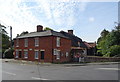
Daily life for residents of CB10 2UU revolves around a practical network of amenities within easy reach of the village homes. For shopping needs, you have access to five local retail outlets, with Co-op Linton, Tesco Saffron, and Waitrose Saffron being the most notable options nearby. These stores provide essential groceries and household goods without requiring a long journey into larger towns. Transport connections are supported by two railway stations, Great Chesterford Railway Station and Audley End Railway Station, which are practical gatesways for visitors and those needing to travel further. These stations connect the village to the wider rail network, facilitating journeys to cities like London or Cambridge when necessary. Beyond shops and trains, the village character includes local leisure spots like the Rose & Crown pub and the nearby Marpa House Buddhist retreat. You will find that lifestyle here is defined by these specific, reachable facilities rather than a wide variety of international chains. The proximity of these amenities ensures that most daily errands remain a local outing, preserving the quiet nature of the neighbourhood while maintaining convenient access to services.
Amenities
Schools
Families living in CB10 2UU have access to Ashdon Primary School, which holds a good Ofsted rating. As a primary institution, this school serves the educational needs of younger children within the parish boundaries. The data does not include any secondary schools listed directly for this postcode, which is typical for rural areas where older students travel to larger towns for advanced education. The presence of a single community school fosters a tight educational network where children from the local valley and hill settlements attend together. This setup creates a unified school group network that often extends across the wider parish, bringing families from hamlets like Newnham and Bartlow End under one educational umbrella. For those concerned about OFsted ratings, the good status of Ashdon Primary School provides reassurance regarding the quality of early education. You will need to look further afield for high school options, but the primary stage of education is well-supported locally. The school serves as a central community hub for families, organising events that integrate residents from the different historic parts of the village.
| Rank | School | Type | Entry gender | Ages |
|---|
Explore more schools in this area
Go to Schools tabDemographics
The community within CB10 2UU reflects a mature population with a median age of 47 years. The majority of residents fall into the 30-64 year age bracket, indicating a neighbourhood dominated by adults likely in their peak earning years or approaching retirement. House ownership stands at a high level of 79%, which signals that most people in the area have bought through the property ladder rather than renting. This high rate of ownership typically correlates with long-term stability and community investment. The predominant accommodation type consists of houses, aligning with the rural character of the village and contrasting with dense urban blocks. While the area is predominantly White, the statistics indicate a primarily homogeneous demographic. There are no specific figures provided for deprivation within this exact postcode, but the high home ownership rate suggests a generally settled population. The low population density of 55 people per square kilometre further reinforces a tranquil living environment free from the crowding associated with larger towns. You will find that the 1,749 residents make decisions collectively as a close community rather than a transient workforce. This demographic profile creates a stable environment where families and individuals seek to settle down.
Household Size
Accommodation Type
Tenure
Ethnic Group
Religion
Household Composition
Age
Household Deprivation
NS-SEC
Explore more demographic insights in this area
Go to Demographics tabPlanning
Planning Constraints
- Flood RiskPremium
- Ramsar Wetland SitesPremium
- Area of Outstanding Natural BeautyPremium
- Protected Nature ReservePremium
- Protected WoodlandPremium