Area Overview for CB1 2AF
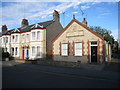
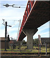
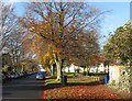
Photos of CB1 2AF


Area Information
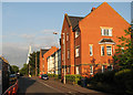
Living in CB1 2AF means being part of a small, tightly knit residential cluster in Cambridge, England. With a population of just 1,974, the area feels intimate, offering a quiet alternative to the city’s busier districts. Situated in the Petersfield Ward, it benefits from Cambridge’s historical and cultural heritage, including medieval roots and proximity to the town’s administrative heart. The area is characterised by its predominantly older residents, with a median age of 47, suggesting a mature, settled community. Daily life here is shaped by proximity to Cambridge’s amenities, including independent schools, rail links, and retail hubs. The postcode’s small size means residents are likely to know their neighbours, though the area’s limited size also means it’s a niche choice for those seeking a balance between urban access and residential tranquillity. CB1 2AF is not a sprawling suburb but a focused cluster, ideal for those prioritising convenience over expansive space. Its appeal lies in its blend of historical context, practical connectivity, and a community profile that leans towards home ownership and family stability.
- Area Type
- Postcode
- Area Size
- Not available
- Population
- 1974
- Population Density
- 7438 people/km²
The property market in CB1 2AF is defined by its small size and focus on owner-occupied homes. With 43% of residents owning their properties, the area leans more towards home ownership than rental activity. The accommodation type is predominantly houses, which are typically larger and more permanent than flats, aligning with the mature age profile of the community. This suggests a market suited to families or professionals seeking long-term stability. However, the limited population and small footprint of the postcode mean the housing stock is not extensive, and buyers may need to consider nearby areas for more options. The absence of high-density housing or student accommodation indicates that CB1 2AF is not a hotbed for rental demand or speculative investment. For buyers, this means a focus on individual properties rather than a dynamic market with fluctuating prices. The area’s compact nature also means proximity to Cambridge’s broader property market is key, with potential for growth tied to the city’s overall trends.
House Prices in CB1 2AF
No properties found in this postcode.
Energy Efficiency in CB1 2AF
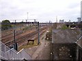
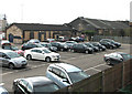
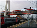
Residents of CB1 2AF have access to a range of amenities within practical reach, including Sainsburys Cambridge, M&S Cambridge Rail SF, and Tesco Cambridge, ensuring everyday shopping needs are met. The area’s proximity to Cambridge North, Shelford, and Waterbeach railway stations means easy access to the city’s cultural and commercial hubs. While the postcode itself is small, its location in Cambridge means residents can enjoy the city’s broader offerings, from dining to leisure. The presence of Cambridge Airport adds to the area’s connectivity, though local parks or recreational spaces are not explicitly mentioned in the data. The lifestyle here is practical, with a focus on accessibility over sprawling green spaces. The mix of retail and transport options supports a convenient, low-stress daily life, though the area’s limited size means it’s best suited for those who prioritise proximity to Cambridge’s amenities over expansive local facilities.
Amenities
Schools
Nearby schools in CB1 2AF include St Colette’s Preparatory School, an independent institution, and St. Andrew’s College Cambridge, also independent, with a good Ofsted rating. These schools cater to families seeking private education, offering alternatives to state-run institutions. The presence of two independent schools suggests the area attracts households prioritising tailored education, though no state schools are listed in the data. For families, this means access to high-quality private schooling, though it also implies a potential reliance on commuting for younger children or those requiring state education. The absence of state school data means it’s unclear how well the area serves those without private schooling preferences. The good Ofsted rating for St. Andrew’s College Cambridge indicates a strong educational offering, which could be a draw for families valuing academic standards. However, the limited school options highlight that CB1 2AF is not a standalone educational hub but part of Cambridge’s broader network.
| Rank | School | Type | Entry gender | Ages |
|---|
Explore more schools in this area
Go to Schools tabDemographics
The community in CB1 2AF is predominantly composed of adults aged 30–64, with a median age of 47. This suggests a mature, established population, likely with long-term ties to the area. Home ownership rates stand at 43%, indicating that nearly half of residents own their homes, while the remaining 57% may be renting. The area is dominated by houses rather than flats, reflecting a preference for single-family dwellings. The predominant ethnic group is White, with no data provided on other demographics. The population size of 1,974 means the area is small enough to foster a close-knit community but limited in scale for broader social diversity. The age profile implies a mix of professionals and families, though the absence of specific data on deprivation or income levels means it’s unclear how economic factors influence quality of life. The demographic profile suggests a stable, low-turnover environment where residents may be less transient than in larger urban areas.
Household Size
Accommodation Type
Tenure
Ethnic Group
Religion
Household Composition
Age
Household Deprivation
NS-SEC
Explore more demographic insights in this area
Go to Demographics tabPlanning
Planning Constraints
- Flood RiskPremium
- Ramsar Wetland SitesPremium
- Area of Outstanding Natural BeautyPremium
- Protected Nature ReservePremium
- Protected WoodlandPremium