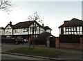
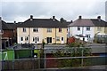
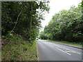
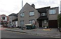
Area Overview for Buckhurst Hill West Ward
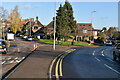
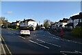
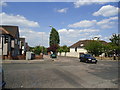
Photos of Buckhurst Hill West Ward

Area Information
Buckhurst Hill West Ward occupies a distinct position within the Epping Forest District of England, spanning an area of 2.7 square kilometres. This electoral ward has served as a council division since 1979 and sits at approximately 51°37′26″N 0°02′28″E. Living in Buckhurst Hill West Ward means residing in one of two official wards that represent the town of Buckhurst Hill. The location falls squarely within the Eastern England region, offering residents a defined geographical identity. You are stepping into a specific administrative area with a long historical roots established decades ago. The ward provides a clear boundary for local governance and community representation. When you consider homes in Buckhurst Hill West Ward, you are choosing a location with established local structures. Daily life here is framed by the boundaries of this local district. The area offers a concrete sense of place for those seeking a defined home location. You gain access to a recognised ward with specific roles in local administration.
- Area Type
- District Borough Unitary Ward
- Area Size
- 2.7 km²
- Population
- Not available
- Population Density
- Not available
Demographics
The community within Buckhurst Hill West Ward is defined by a substantial proportion of older residents. The median age for the population reaches 70 years, indicating a significant demographic shift towards older age groups. You will find that the most common age range covers the total population, reflecting this overarching trend. A key characteristic of this neighbourhood is that 75 per cent of residents live in owner-occupied homes. This high level of home ownership suggests a settled population with strong local ties. Household composition and accommodation types total across the ward, painting a picture of varied living arrangements. You should note that predominant ethnic group and religious data are recorded as totals for the area. This simplicity reflects the aggregate nature of the census figures available. When looking at deprivation data, the context reveals a community focused on ownership rather than rental instability. The majority owning their homes means fewer tenants and more long-term residents. Your neighbour is likely to be one of these 75 per cent who has secured their property. This stability shapes the social fabric of Buckhurst Hill West Ward significantly.
Household Size
Accommodation Type
Tenure
Ethnic Group
Religion
Household Composition
Age
Household Deprivation
NS-SEC
Explore more demographic insights in this area
Go to Demographics tabPlanning
Planning Constraints
- Flood RiskPremium
- Ramsar Wetland SitesPremium
- Area of Outstanding Natural BeautyPremium
- Protected Nature ReservePremium
- Protected WoodlandPremium
- Crime RiskPremium