Area Overview for Brogborough
Photos of Brogborough


Area Information
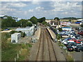
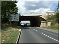
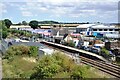
Brogborough is a compact built-up area in England, covering 59.6 hectares — roughly the size of a large football pitch. It is a place defined by its older population, with a median age of 70, suggesting a community that may lean towards retirement or long-term residents. Despite its modest size, Brogborough offers practical access to key amenities, including five rail stations within reach, such as Ridgmont and Aspley Guise, and major retailers like Sainsburys Wavendon and Co-op Woburn. The area’s proximity to Cranfield Airport adds to its connectivity, though it remains a quieter, less densely populated part of the region. Daily life here is likely shaped by the balance between local services and nearby transport links, making it suitable for those prioritising convenience over urban vibrancy. Brogborough’s character is one of simplicity, with a focus on accessibility and stability, appealing to those who value a slower pace of life without sacrificing essential facilities.
- Area Type
- Built Up Area 250
- Area Size
- 59.6 hectares
- Population
- Not available
- Population Density
- Not available
Residents of Brogborough have access to a range of amenities within practical reach. For shopping, the area is served by Sainsburys Wavendon, Co-op Woburn, and Tesco Woburn, providing everyday essentials and larger retail options. The five nearby rail stations, including Lidlington Railway Station, offer convenient links to surrounding areas, making it easy to travel for work, leisure, or socialising. While the data does not mention parks or recreational spaces, the presence of multiple retail and transport hubs suggests a focus on practicality over expansive green areas. The area’s proximity to Cranfield Airport may also appeal to those requiring occasional travel. Overall, Brogborough’s lifestyle is characterised by ease of access to services, though it may lack the cultural or natural amenities found in more densely populated regions.
Amenities
Schools
| Rank | School | Type | Entry gender | Ages |
|---|
Explore more schools in this area
Go to Schools tabDemographics
Brogborough’s population skews significantly towards older age groups, with a median age of 70. This suggests a community where retirees or long-term residents predominate, potentially shaping local services and social dynamics. Home ownership in the area stands at 59%, indicating a mix of owner-occupied properties and rental units. The data does not specify household composition or accommodation types, but the overall figures imply a stable, possibly family-oriented demographic. With no detailed breakdown of ethnic or religious diversity, it is unclear how varied the community’s cultural makeup might be. However, the lack of specific deprivation data means it is difficult to assess whether quality of life here is consistently high or if certain groups face challenges. The area’s older population may influence local amenities, with services tailored to their needs rather than those of younger families or professionals.
Household Size
Accommodation Type
Tenure
Ethnic Group
Religion
Household Composition
Age
Household Deprivation
NS-SEC
Explore more demographic insights in this area
Go to Demographics tabPlanning
Planning Constraints
- Crime RiskPremium