Area Overview for Bramingham Ward
Photos of Bramingham Ward
Area Information
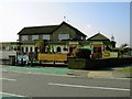
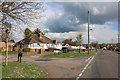
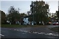
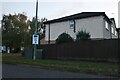
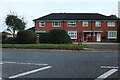
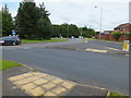
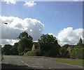
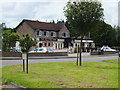
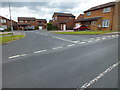
Bramingham Ward is a distinct district within the Borough of Luton, covering a compact area of 3.2 square kilometres. Situated in the north of Luton, roughly five miles from the town centre, the ward offers a semi-rural feel while maintaining access to essential services. The land is bounded by the A6 to the east, Great Bramingham Wood to the west, and Icknield Way to the south. The landscape is defined by a blend of modern suburban development and ancient history. Great Bramingham Wood, an ancient woodland managed by the Woodland Trust, provides significant green space with a network of footpaths. This wood is known for spectacular spring bluebell displays and pink campion flowering in cleared areas. The residential character reflects rapid growth during the 1980s and 1990s. Most housing consists of low-density suburban properties built in a traditional style, often featuring mock timber frames or arched windows. Scattered 19th-century cottages on Great Bramingham Lane offer historical contrast to the newer developments. Local amenities are centred around a parade of shops that includes a large Sainsbury's supermarket and a medical centre. The village also hosts Bramingham Park Church and the historic The Brim and Crown public house. Residents enjoy a community shaped by the presence of Keech Cottage Hospice, a care charity on the former Great Bramingham Farm land. Living here means experiencing a peaceful environment where modern family homes coexist with designated parks, protected ancient woodlands, and established shops within a clearly defined boundary.
- Area Type
- District Borough Unitary Ward
- Area Size
- 3.2 km²
- Population
- Not available
- Population Density
- Not available
Demographics
The community in Bramingham Ward has a clear demographic profile, with a median age of 70. This figure indicates that the population skews significantly towards older residents. While the data does not specify a narrow age bracket as the most common, the high median age suggests a considerable proportion of retirees or long-term residents over sixty. Home ownership is entrenched in the area, with 76% of properties owned outright or with a mortgage. This high percentage points towards a stability where most residents are tied to their local homes for the long term rather than being transient tenants. The ward functions as a settled neighbourhood where the majority of households consist of owner-occupiers. There is no indication of high turnover or rental social housing dominance, which often correlates with younger populations entering the market. The diversity and specific household composition details are not detailed in the available figures, but the ownership rate provides a strong signal of community continuity. The combination of an older demographic and high ownership rates creates a quiet, established atmosphere. You are likely to find neighbours who have lived in their Bramingham Ward homes for decades. This structure supports a community focused on retention rather than the transient nature of a rental borough.
Household Size
Accommodation Type
Tenure
Ethnic Group
Religion
Household Composition
Age
Household Deprivation
NS-SEC
Explore more demographic insights in this area
Go to Demographics tabPlanning
Planning Constraints
- Flood RiskPremium
- Ramsar Wetland SitesPremium
- Area of Outstanding Natural BeautyPremium
- Protected Nature ReservePremium
- Protected WoodlandPremium
- Crime RiskPremium