Area Overview for Botesdale and Rickinghall
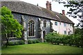
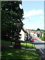
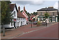
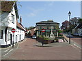
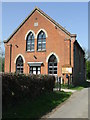
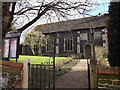
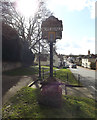
Photos of Botesdale and Rickinghall


Area Information
Botesdale and Rickinghall is a compact built-up area in England, spanning 80.6 hectares. Its population, though not quantified, is predominantly older, with a median age of 70. This suggests a community shaped by long-term residency and established local connections. The area’s small size means amenities and services are closely clustered, making daily life convenient. Residents benefit from proximity to two primary schools, including St Botolph’s Church of England Voluntary Controlled Primary School, which holds a good Ofsted rating. The area’s appeal lies in its quiet, stable character, supported by low crime risk and strong digital connectivity. For those seeking a place with a slower pace of life, Botesdale and Rickinghall offers a blend of practicality and security, with homes primarily owner-occupied and a focus on local infrastructure. Its compact nature ensures that essential services are within easy reach, from retail outlets to rail links, creating a self-contained environment.
- Area Type
- Built Up Area 250
- Area Size
- 80.6 hectares
- Population
- Not available
- Population Density
- Not available
Residents of Botesdale and Rickinghall have access to a range of local amenities, including five retail outlets such as Co-op Rickinghall, Spar, and Co-op Stanton. These shops provide everyday essentials, reducing the need for long commutes to larger towns. The Diss Railway Station offers rail connectivity, linking the area to broader transport networks. While the data does not specify parks or leisure facilities, the presence of multiple retail options and a railway station suggests a practical, community-focused lifestyle. The compact nature of the area ensures that daily errands and travel are manageable, contributing to a convenient, low-stress environment for residents.
Amenities
Schools
Residents of Botesdale and Rickinghall have access to two primary schools: St Botolph’s Church of England Voluntary Controlled Primary School and Rickinghall VC Primary School. The former holds a good Ofsted rating, reflecting a school with strong performance and quality education. The presence of two primary schools within the area ensures that families have options for their children’s early education, though the data does not specify secondary schooling proximity. The mix of school types suggests a range of educational approaches, from faith-based to community-focused, catering to different family preferences. For parents, this diversity may provide flexibility in choosing a school that aligns with their values and needs.
| Rank | A + A* % | School | Type | Entry gender | Ages |
|---|---|---|---|---|---|
| 1 | N/A | St Botolph's Church of England Voluntary Controlled Primary School | primary | N/A | N/A |
| 2 | N/A | Rickinghall VC Primary School | primary | N/A | N/A |
Explore more schools in this area
Go to Schools tabDemographics
The population of Botesdale and Rickinghall has a median age of 70, indicating a community skewed towards older adults. This demographic profile suggests a population with long-standing ties to the area, potentially shaped by retirement or generational continuity. Home ownership is high, with 76% of households owning their homes, reflecting a stable, settled population. The data does not specify household composition or accommodation types, but the overall figures imply a low turnover of residents and a focus on long-term living. The absence of detailed information on diversity or deprivation means the area’s social fabric remains largely undefined in the data, but the high home ownership rate and low crime risk suggest a cohesive, low-risk environment for residents.
Household Size
Accommodation Type
Tenure
Ethnic Group
Religion
Household Composition
Age
Household Deprivation
NS-SEC
Explore more demographic insights in this area
Go to Demographics tabPlanning
Planning Constraints
- Crime RiskLocked