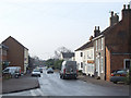
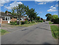
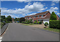
Area Overview for Blofield
Photos of Blofield


Area Information
Blofield is a compact built-up area covering just 1.0 km², nestled in England. Its small size means residents are likely to know their neighbours, fostering a close-knit community. The area’s demographic profile is distinctive, with a median age of 70, suggesting a population skewed towards older adults. This may influence the local character, with a focus on stability and long-term residency. Home ownership is high, at 73%, indicating a strong presence of owner-occupied properties. Daily life here is shaped by proximity to essential services, including nearby schools and transport links. The area’s small footprint ensures amenities are within practical reach, making it convenient for those prioritising accessibility over sprawling urban landscapes. While the data does not specify cultural or ethnic diversity, the area’s safety score and connectivity suggest it is a practical choice for those seeking a secure, well-served environment. Blofield’s blend of modest scale and functional infrastructure makes it an appealing option for buyers seeking a settled, community-focused lifestyle.
- Area Type
- Built Up Area 250
- Area Size
- 1.0 km²
- Population
- Not available
- Population Density
- Not available
Blofield’s lifestyle is shaped by its proximity to essential amenities. Within the area, residents have access to five retail outlets, including Co-op stores and a Spar, ensuring everyday shopping needs are met. The rail network is particularly robust, with five stations nearby, including Brundall Railway Station and Brundall Gardens Railway Station, offering frequent services to surrounding areas. The Wroxham Metro provides an additional transport option, enhancing connectivity. While the data does not list parks or leisure facilities, the presence of multiple retail and transport hubs suggests a practical, convenience-driven lifestyle. The area’s compact size means amenities are within walking or short driving distance, reducing the need for lengthy commutes. This makes Blofield ideal for those valuing accessibility and a straightforward, functional daily routine.
Amenities
Schools
The nearest school to Blofield is Blofield Primary School, which serves the local community with a good Ofsted rating. This single primary school is the only named institution listed in the data, meaning the area does not have a range of school types, such as secondary or specialist institutions. For families with young children, Blofield Primary School offers a reliable option, though the absence of secondary schools nearby may require commuting to adjacent areas. The good Ofsted rating indicates a satisfactory standard of education, but the limited variety of schools may impact choice for households with older children. Buyers should consider proximity to secondary education if this is a priority, as the data does not suggest additional schools within the immediate vicinity.
| Rank | School | Type | Entry gender | Ages |
|---|
Explore more schools in this area
Go to Schools tabDemographics
The population of Blofield has a median age of 70, reflecting a community predominantly composed of older residents. The most common age range is listed as “Age: Total,” which may indicate aggregated data rather than specific breakdowns. Home ownership is high, with 73% of residents owning their homes, suggesting a stable, long-term demographic. The data does not specify household composition or accommodation types, but the overall figure implies a mix of family homes and single-occupancy properties. There is no information on ethnic diversity or religious composition, so these aspects remain unexplored. The high home ownership rate may correlate with lower turnover, contributing to a sense of continuity. For those considering Blofield, the age profile and ownership statistics suggest a community prioritising security and familiarity over rapid change.
Household Size
Accommodation Type
Tenure
Ethnic Group
Religion
Household Composition
Age
Household Deprivation
NS-SEC
Explore more demographic insights in this area
Go to Demographics tabPlanning
Planning Constraints
- Crime RiskPremium