Area Overview for Berkhamsted Castle Ward
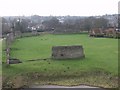
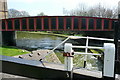
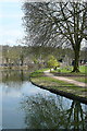
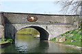
Photos of Berkhamsted Castle Ward
Area Information
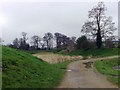
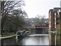
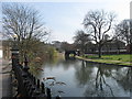
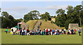
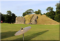
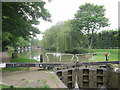
Berkhamsted Castle Ward represents a compact yet historically significant district within Hertfordshire. You are looking at an area covering just 3.8 square kilometres, which places it firmly in the category of a tight-knit community where neighbours know each other. This ward is one of three local government units, alongside East and West, that form the civil parish and market town of Berkhamsted. It sits within Dacorum Borough in England, situated 26 miles or 42 kilometres north-west of London amidst the Chiltern Hills. At its heart lies Berkhamsted Castle, a Norman motte-and-bailey construction located in the Bulbourne Valley. The site features substantial remains dating from the 11th to the 15th century, including walls, ditches, earthworks, and a 13th-century palace complex added by Richard, Earl of Cornwall. You can find these ruins at coordinates approximately 51.764°N, 0.558°W, managed by English Heritage. Daily life here revolves around this historic landmark and the adjoining railway station. Berkhamsted Castle Ward is part of a larger settlement on the West Coast Main Line. Living in Berkhamsted Castle Ward means you have immediate access to a site ordered by William the Conqueror during the 1066 Norman Conquest. Robert of Mortain originally managed its build, and the castle later became an administrative centre favoured by historical figures. The area offers a blend of living convenience and tangible history in a defined geographical footprint.
- Area Type
- District Borough Unitary Ward
- Area Size
- 3.8 km²
- Population
- Not available
- Population Density
- Not available
Demographics
The community within Berkhamsted Castle Ward presents a clear demographic profile centred on older residents. The median age stands at exactly 70. This statistic indicates that the population is significantly older than the national average. You will find that the most common age group falls under the category of Age Total, suggesting the data covers the full range of the population aged classification. Home ownership is a defining feature of life here, with 76 per cent of the ward owned outright. This high level of ownership suggests a stable, long-term settlement where residents are likely to have stayed for decades. Household composition and accommodation types follow this owner-occupied pattern, creating an environment where tenancy is less common than freehold or leasehold living. The ward maintains a low crime risk, scoring 74 out of 100 on a safety scale. This low score indicates below-average crime rates compared to other neighbourhoods. You can expect a generally secure environment for your daily activities. Specific figures for the predominant ethnic group, religion, and detailed household breakdowns are not detailed in the current dataset, but the overarching theme remains one of older, owner-occupied stability. Living in Berkhamsted Castle Ward means you are joining a population that is retired or close to it, valuing security and established community patterns.
Household Size
Accommodation Type
Tenure
Ethnic Group
Religion
Household Composition
Age
Household Deprivation
NS-SEC
Explore more demographic insights in this area
Go to Demographics tabPlanning
Planning Constraints
- Flood RiskPremium
- Ramsar Wetland SitesPremium
- Area of Outstanding Natural BeautyPremium
- Protected Nature ReservePremium
- Protected WoodlandPremium
- Crime RiskPremium