Area Overview for Berechurch Ward
Photos of Berechurch Ward

Area Information
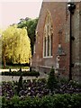
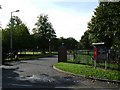
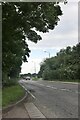
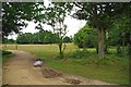
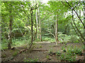
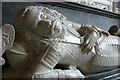
Berechurch Ward sits south of Colchester town centre within the unitary authority of Colchester Borough Council in Essex. The area covers 6.5 km² and serves a population of 3,552 residents. This outlying parish originated as part of the Saxon estate of Donyland before becoming one of Colchester's sixteen parishes by the 14th century. St Michael's Church, a Grade II* listed redundant building featuring a late 15th or early 16th-century red brick tower, anchors the local history. The site includes an Audley Chapel containing a 1648 memorial to Sir Henry Audley. Residents live near Berechurch Dyke, an Iron Age scheduled monument forming the eastern edge of a prehistoric oppidum. Living in Berechurch Ward offers proximity to these significant historical markers while maintaining a compact footprint. The community settled into a single parish in 1897, blending old-world heritage with modern conveniences. You can find homes in Berechurch Ward within a defined district that balances rural connections with access to the broader Colchester borough. The quieter, more historical nature of the location suits those seeking a grounded environment outside the main town centre.
- Area Type
- District Borough Unitary Ward
- Area Size
- 6.5 km²
- Population
- 3552
- Population Density
- 548 people/km²
Demographics
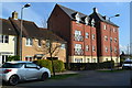
The community profile reveals an older demographic with a median age of 70 years. This indicates a neighbourhood where many residents are likely retired or nearing retirement. You are looking at an area where longevity and stability define daily life. Home ownership stands high at 61%, suggesting most residents own their properties outright or with a mortgage. This contrasts with areas dominated by private rentals. The predominant household composition and accommodation type data confirm the area is established rather than transient. While specific figures on ethnic diversity and religious affiliation are not detailed in the provided statistics, the overall picture points to a settled, long-term resident base. The age structure implies that when you consider living in Berechurch Ward, you should expect more leisure-focused atmospheres than high-energy parenting hubs. Services and local businesses likely cater to an older demographic. Contrasted with younger urban boroughs, this ward reflects the needs of those prioritising peace and stability over speed.
Household Size
Accommodation Type
Tenure
Ethnic Group
Religion
Household Composition
Age
Household Deprivation
NS-SEC
Explore more demographic insights in this area
Go to Demographics tabPlanning
Planning Constraints
- Flood RiskPremium
- Ramsar Wetland SitesPremium
- Area of Outstanding Natural BeautyPremium
- Protected Nature ReservePremium
- Protected WoodlandPremium
- Crime RiskPremium