Area Overview for Beaumont-cum-Moze
Photos of Beaumont-cum-Moze


Area Information
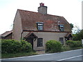
Beaumont-cum-Moze is a civil parish located in Essex, covering an area of 13.2 square kilometres. The place name combines historical elements: "Beaumont" evolved from Saxon roots meaning "beautiful hill," while "Moze" derives from the Old English word for marsh or moss. This linguistic duality reflects the parish's landscape, which historically included woodland, meadows, and a creek that supported marine activity such as salthouses. You will find the Parish Church of St Leonard and St Mary standing in the area, an 11th-century building that underwent major restoration beginning in 1854. Living in Beaumont-cum-Moze involves engaging with a community that traces its roots back to the Domesday Book of 1086, where it was recorded as a holding of Aubrey de Vere. The parish included agricultural land, seven ploughs, and woodland alongside the creek's economic significance. Today, you can visit Beaumont Quay, constructed in 1832, which features a surviving quayside building and a limestone plaque commemorating its origin. The area also contains a derelict canal known as Beaumont Cut. Local history includes the burial of Julian Byng, 1st Viscount Byng of Vimy, at the parish church. Your daily life here is shaped by this extensive history, the remaining textile of the medieval settlement, and the quiet character of a parish that once supported close to 450 people.
- Area Type
- Parish
- Area Size
- 13.2 km²
- Population
- Not available
- Population Density
- Not available
Demographics
The community in Beaumont-cum-Moze is defined by a median age of 70 years. This high average indicates a population where older residents are the standard demographic. The most common age range recorded is listed as "Age: Total," which suggests a数据统计 presentation where the full population is aggregated rather than split into younger brackets. With a home ownership rate of 71%, the area reflects a community where residents typically own their residences rather than rent. You should be aware that the specific breakdowns for household composition, accommodation types, predominant ethnic groups, and religious affiliations are currently listed as "total" or unspecified in the available records. These placeholders indicate that fine-grained demographic splits, such as the percentage of households with children or specific ethnic compositions, are not detailed in the current dataset. Consequently, you cannot determine if the area has a small, localised minority population or a specific religious make-up beyond a general "total" classification. Your understanding of deprivation in this specific location is similarly limited by the data structure. While the raw data provided does not contain a standard deprivation index score or a description of what that deprivation level means for quality of life, you must rely on the visible figures of age and ownership as your primary indicators of the social profile. The high home ownership rate often correlates with established neighbourhoods, but without explicit deprivation metrics, you cannot assess economic challenges faced by residents in Beaumont-cum-Moze.
Household Size
Accommodation Type
Tenure
Ethnic Group
Religion
Household Composition
Age
Household Deprivation
NS-SEC
Explore more demographic insights in this area
Go to Demographics tabPlanning
Planning Constraints
- Flood RiskPremium
- Ramsar Wetland SitesPremium
- Area of Outstanding Natural BeautyPremium
- Protected Nature ReservePremium
- Protected WoodlandPremium
- Crime RiskPremium