Area Overview for Barling Magna
Photos of Barling Magna

Area Information
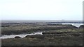
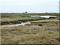
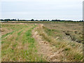
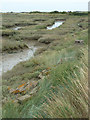
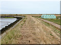
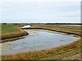
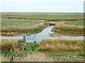
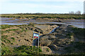
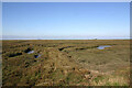
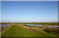
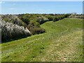
Barling Magna stands as a distinct civil parish covering an area of 15.9 km² in England. The location presents two contrasting realities for anyone considering moving to the region. You enjoy excellent digital connectivity with a fixed broadband quality score of 95, making remote work highly feasible. However, you face significant environmental constraints due to high flood risk. Of the total area, 64.3 indicates a critical safety concern where flood water coverage is extensive. This duality defines daily life here. Residents benefit from reliable high-speed internet but must navigate a landscape mapped with critical flood risk data. The presence of Ramsar wetland sites and protected nature reserves further shapes the area, occupying a significant portion of the land. While there is no designated Area of Outstanding Natural Beauty or protected woodland, these designations restrict development and influence land values. Living in Barling Magna means accepting a rural setting where nature conservation takes precedence over expansive housing plans. You should prioritise properties away from flood zones if you intend to occupy a home in this parish long-term.
- Area Type
- Parish
- Area Size
- 15.9 km²
- Population
- Not available
- Population Density
- Not available
Demographics
The community profile of Barling Magna reflects a mature population structure. The median age sits at 70, confirming that the area hosts a predominantly older demographic. Most residents fall into an age range indicating a static or retirement-focused society. This age profile aligns with the fact that 78% of homes are owner-occupied. Such a high ownership rate typically signals residents who have settled permanently rather than transient tenants. You are unlikely to encounter a young rental market or frequent house flipping in this specific parish. The accommodation types and household composition data suggest that families and retired couples dominate the resident count. Diversity metrics are not explicitly quantified in the available statistics, so the community likely mirrors the broader national trend of gradual ethnic diversification over recent decades. Religion and predominant ethnic group data are not detailed in the specific figures provided for this parish, meaning the community remains traditional in its composition. When evaluating homes in Barling Magna, expect a quiet environment where neighbours often know each other for decades.
Household Size
Accommodation Type
Tenure
Ethnic Group
Religion
Household Composition
Age
Household Deprivation
NS-SEC
Explore more demographic insights in this area
Go to Demographics tabPlanning
Planning Constraints
- Flood RiskLocked
- Ramsar Wetland SitesLocked
- Area of Outstanding Natural BeautyLocked
- Protected Nature ReserveLocked
- Protected WoodlandLocked
- Crime RiskLocked