Area Overview for Aspley Heath
Photos of Aspley Heath
Area Information
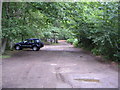
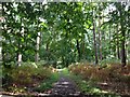
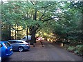
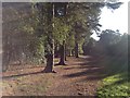
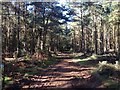
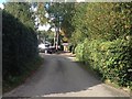
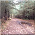
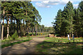
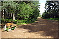
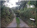
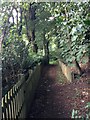
You will find Aspley Heath to be a quiet village and civil parish situated within the Central Bedfordshire district. This settlement spans just 2.4 km², placing it firmly within the Milton Keynes Built-up area according to the Office for National Statistics. The geography is distinctive; the parish sits on the borders of Buckinghamshire and Bedfordshire, adjoined by Woburn Sands to the north and Woburn to the south. Early in the morning, residents wake to a landscape shaped by the Greensand Ridge, which provides a gentle elevation. The highest point, the Knoll, reaches approximately 545 feet, while St Michael's Church stands just over 400 feet above sea level. This elevated position contributes to a microclimate that has been considered a particularly healthy spot since the 18th century. The terrain features extensive woodlands and open heathland, including Aspley Woods, which represent one of the largest stretches of woodland in Bedfordshire. Walking paths are generally well-defined bridleways and footpaths, though they can become muddy after rain. The linear form of the village guides daily movement through a space characterised by large detached houses set in extensive grounds. Created in 1883, the parish retains a conservation area designation from 1994, preserving its historic streetscape where Church Road is notably bordered by hedgerows of holly. Living here means existing within a setting defined by this specific historical topography rather than rapid urban expansion.
- Area Type
- Parish
- Area Size
- 2.4 km²
- Population
- Not available
- Population Density
- Not available
Demographics
The community within Aspley Heath displays a clear demographic profile skewed towards an older population. The median age stands at 70, indicating a settlement where residents tend to be retired individuals seeking a peaceful environment. Data confirms that the age range of the total population centres around this high figure. This demographic structure aligns with a high level of stability, evidenced by a home ownership rate of 64 per cent. Nearly two-thirds of residents own their properties outright, suggesting a strong attachment to the local area and significant equity within the community. The household composition breakdown covers the total population, reflecting a mix of family units and single-person households typical of mature villages. While specific data on predominant ethnic groups and religious affiliations are not detailed in current records, the 64 per cent ownership figure strongly implies a settled community with long-term residents rather than a transient workforce. This lack of short-term tenancy usually fosters tighter neighbourly bonds and a slower pace of life. The area does not experience the churn typical of student towns or commuter enclaves with high rental inventories. Instead, the population remains relatively static, allowing residents to maintain established routines. The high proportion of owner-occupied homes means that decision-making regarding changes to the village character often involves established homeowners who prioritise the conservation of the area's unique features.
Household Size
Accommodation Type
Tenure
Ethnic Group
Religion
Household Composition
Age
Household Deprivation
NS-SEC
Explore more demographic insights in this area
Go to Demographics tabPlanning
Planning Constraints
- Flood RiskLocked
- Ramsar Wetland SitesLocked
- Area of Outstanding Natural BeautyLocked
- Protected Nature ReserveLocked
- Protected WoodlandLocked
- Crime RiskLocked