Area Overview for Alconbury Weston
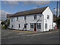
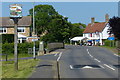
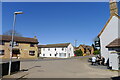
Photos of Alconbury Weston


Area Information
Alconbury Weston is a built-up area in England covering 33.8 hectares, characterised by a compact layout typical of smaller towns. With a median age of 70, the population reflects a community skewed towards older residents, suggesting a settled, long-term demographic. The area’s proximity to Huntingdon Railway Station offers direct links to nearby towns, while local shops like Spar, Co-op Alconbury, and M&S Brampton Hut BP provide everyday convenience. Home ownership here is high, at 81%, indicating a stable, owner-occupied environment. Daily life in Alconbury Weston balances practicality with accessibility, with amenities within walking or short driving distance. The area’s modest size and established retail presence make it a self-contained option for those prioritising ease of living over sprawling urban sprawl. For buyers, the combination of low crime risk and reliable transport infrastructure adds to its appeal as a secure, functional place to live.
- Area Type
- Built Up Area 250
- Area Size
- 33.8 hectares
- Population
- Not available
- Population Density
- Not available
Living in Alconbury Weston offers access to a range of local amenities that support daily life. The area’s retail options include Spar, Co-op Alconbury, and M&S Brampton Hut BP, providing essentials and convenience for shoppers. The Huntingdon Railway Station is a key transport hub, connecting residents to broader destinations. While the data does not mention parks or leisure facilities, the proximity to retail and transport infrastructure ensures a practical lifestyle. The compact layout of the area means amenities are within easy reach, reducing the need for long commutes. For those who value self-sufficiency, the combination of local shops and rail access makes Alconbury Weston a functional choice. The absence of detailed information on recreational spaces means buyers should explore the area personally to assess its full lifestyle offerings.
Amenities
Schools
| Rank | A + A* % | School | Type | Entry gender | Ages |
|---|
Explore more schools in this area
Go to Schools tabDemographics
The population of Alconbury Weston has a median age of 70, with the most common age range encompassing all age groups. This suggests a community where older residents form a significant proportion, potentially influencing local services and social dynamics. Home ownership is high, at 81%, which typically correlates with long-term residency and community stability. The data does not specify household composition or accommodation types, but the overall figures indicate a population that is largely settled, with few transient residents. While no specific diversity metrics are provided, the area’s demographics reflect a homogenous profile, which may shape the character of local interactions and amenities. The absence of detailed breakdowns on ethnicity or religion means the community’s cultural fabric remains less defined in the data. For prospective buyers, the high home ownership rate and older demographic suggest a quiet, low-maintenance environment.
Household Size
Accommodation Type
Tenure
Ethnic Group
Religion
Household Composition
Age
Household Deprivation
NS-SEC
Explore more demographic insights in this area
Go to Demographics tabPlanning
Planning Constraints
- Crime RiskLocked