Area Overview for Alby with Thwaite
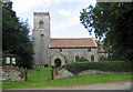
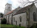
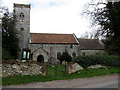
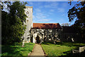
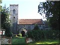
Photos of Alby with Thwaite

Area Information
Living in Alby with Thwaite means settling into a civil parish defined by its compact footprint and quiet character. This small area covers just 5.8 km², meaning the community is physically close-knit and easily navigable on foot or by local bus. You will find a environment where daily life centres around neighbourhood camaraderie rather than urban bustle. The parish sits within England, offering a distinct rural setting that stands away from the immediate pressures of major cities. Residents here experience a pace of life that prioritises stability. The total area size suggests limited expansion, which inherently limits the volume of new developments but preserves the established landscape. When you consider homes in Alby with Thwaite, you are looking at a settled locality where boundaries are clearly defined. The demographic profile reinforces this sense of permanence, as the village has long been a home for those seeking a slower rhythm. Daily life involves familiar surroundings and a lack of through-traffic congestion. The parish functions as a self-contained unit where essential services are accessed within a small radius. You can expect a routine where the local pub, village hall, or green space plays a central role. The fixed nature of the parish boundaries ensures that the community identity remains strong and consistent for all who call this 5.8 km² zone home. The community in Alby with Thwaite is heavily skewed towards older residents, creating a distinctly mature social environment. The median age of 70 reflects a population where most people have spent decades building roots in the district. Three-quarters of all households in the parish are owner-occupied, standing at 75%. This high rate of ownership indicates that families and individuals in Alby with Thwaite typically purchase their homes rather than renting. The data shows a clear majority of residents hold the keys to their own properties, suggesting a high level of financial stability within the community. Household composition follows this pattern, with total figures pointing to established domestic units. There is no significant transient population driving the local economy; instead, you find long-term occupants who value security. This demographic profile means the local shops, community groups, and social events cater primarily to seniors and retired couples. The area does not appeal to young professionals or students seeking dynamic urban energy. Instead, it offers a stable environment for those who prioritise peace and quiet. With 75% of homes owned outright, buyers can expect a market driven by investment and retention rather than short-term lettings. The age structure ensures that services are tailored to an elderly clientele. The housing market in Alby with Thwaite is characterised by a strong preference for ownership over renting. With 75% of the accommodation stock in owner-occupied hands, you will find very few rental properties available in the parish. This statistic paints a picture of a community where people buy to stay, not to move quarterly. The dominant presence of owner-occupied dwellings means that the housing supply consists largely of established family homes or retirement properties. When you look at homes for sale in Alby with Thwaite, expect to compete with motivated sellers who have remained in the area for decades. The low volume of the total area, comprising only 5.8 km², further restricts the number of vacant properties. This scarcity naturally limits competition for specific addresses but also reduces the frequency of new listings appearing. The market is not driven by high-turnover speculation or student housing demand. Instead, it reflects a traditional model where residents secure their status as homeowners early in their lives. The majority of the accommodation type is privately owned, which aligns with the older demographic who have paid off mortgages. Buyers seeking rental investment opportunities in Alby with Thwaite face significant hurdles, as the local supply does not support a large let-to-own ratio. The high ownership percentage creates a stable but insular market where residential turnover is slow. Digital connectivity in Alby with Thwaite presents a notable challenge for modern remote lifestyles. The mobile coverage score reaches 77 on a scale of 100, which indicates a good ability to make calls and use mostly data-intensive apps. For residents relying on smartphones for daily communication, this level of service is generally reliable outside combined with the specific terrain constraints of the parish. However, fixed broadband performance is significantly weaker, scoring a 34 out of a possible 100. This poor fixed broadband score suggests that high-speed internet connections, essential for working from home or streaming 4K content, may struggle in parts of the parish. You cannot assume reliable fibre-optic availability just because you own a property in Alby with Thwaite. Mobile data may suffice for basic needs, but video conferencing or large file downloads could face lag and interruptions. This discrepancy between mobile and fixed connectivity means that a digital nomad or remote worker must test sites extensively before committing to a purchase. The area's rural nature exacerbates the limitations of the wireless infrastructure. While the mobile score allows for standard usage, the broadband deficit restricts advanced online activities. Prospective buyers must weigh the satisfactory mobile signal against the risky fixed connection when considering homes in Alby with Thwaite. Safety and environmental factors in Alby with Thwaite are generally reassuring for most residents. The crime risk assessment yields a score of 89 on a 100-point scale, where a higher number denotes less risk. This corresponds to a pass level, confirming that the area has below-average crime rates. You can live here with confidence that violent crime and significant anti-social behaviour are uncommon issues. The low crime risk profile makes Alby with Thwaite a secure choice for families and retirees who prioritize neighbourhood safety. Regarding environmental hazards, the flood risk score stands at 5.16, indicating a very low threat of property damage from water. The risk level is marked as pass, meaning the parish sits outside the main hazard zones. Planning constraints are equally minimal, with zero scores assigned to Ramsar wetland sites, Areas of Outstanding Natural Beauty, protected nature reserves, and protected woodland. These areas also pass all safety criteria, suggesting that the land use is free from major international conservation restrictions that could block development. The absence of protected woodland and AONB coverage allows for straightforward property transactions without unexpected planning hurdles. When comparing this to other rural locations, Alby with Thwaite offers a cleaner safety and environmental record. The combination of low crime and minimal flood risk creates a stable backdrop for long-term living. What is the demographic makeup of Alby with Thwaite?Alby with Thwaite is overwhelmingly an older community with a median age of 70 years old. The high median age reflects a population consisting mostly of retirees and long-term residents rather than young families or students searching for the area. How strong is the internet connection for working from home?Mobile coverage in Alby with Thwaite is good at a score of 77 out of 100. However, fixed broadband is poor with a score of only 34 out of 100. This gap means remote workers relying on stable high-speed connections should verify specific property signals before buying. Is Alby with Thwaite considered a safe place to live?The area scores an 89 on the crime risk scale, where a higher score means lower danger. This confirms low crime rates and marks the parish as having a pass level for safety. Residents can expect an environment with below-average crime statistics. What type of housing stock dominates the local market?Seventy-five percent of housing in Alby with Thwaite is owner-occupied. This high percentage indicates a market driven by long-term residents who have purchased their homes, resulting in very few rental properties available within the parish.
- Area Type
- Parish
- Area Size
- 5.8 km²
- Population
- Not available
- Population Density
- Not available
Demographics
The community in Alby with Thwaite is heavily skewed towards older residents, creating a distinctly mature social environment. The median age of 70 reflects a population where most people have spent decades building roots in the district. Three-quarters of all households in the parish are owner-occupied, standing at 75%. This high rate of ownership indicates that families and individuals in Alby with Thwaite typically purchase their homes rather than renting. The data shows a clear majority of residents hold the keys to their own properties, suggesting a high level of financial stability within the community. Household composition follows this pattern, with total figures pointing to established domestic units. There is no significant transient population driving the local economy; instead, you find long-term occupants who value security. This demographic profile means the local shops, community groups, and social events cater primarily to seniors and retired couples. The area does not appeal to young professionals or students seeking dynamic urban energy. Instead, it offers a stable environment for those who prioritise peace and quiet. With 75% of homes owned outright, buyers can expect a market driven by investment and retention rather than short-term lettings. The age structure ensures that services are tailored to an elderly clientele. The housing market in Alby with Thwaite is characterised by a strong preference for ownership over renting. With 75% of the accommodation stock in owner-occupied hands, you will find very few rental properties available in the parish. This statistic paints a picture of a community where people buy to stay, not to move quarterly. The dominant presence of owner-occupied dwellings means that the housing supply consists largely of established family homes or retirement properties. When you look at homes for sale in Alby with Thwaite, expect to compete with motivated sellers who have remained in the area for decades. The low volume of the total area, comprising only 5.8 km², further restricts the number of vacant properties. This scarcity naturally limits competition for specific addresses but also reduces the frequency of new listings appearing. The market is not driven by high-turnover speculation or student housing demand. Instead, it reflects a traditional model where residents secure their status as homeowners early in their lives. The majority of the accommodation type is privately owned, which aligns with the older demographic who have paid off mortgages. Buyers seeking rental investment opportunities in Alby with Thwaite face significant hurdles, as the local supply does not support a large let-to-own ratio. The high ownership percentage creates a stable but insular market where residential turnover is slow. Digital connectivity in Alby with Thwaite presents a notable challenge for modern remote lifestyles. The mobile coverage score reaches 77 on a scale of 100, which indicates a good ability to make calls and use mostly data-intensive apps. For residents relying on smartphones for daily communication, this level of service is generally reliable outside combined with the specific terrain constraints of the parish. However, fixed broadband performance is significantly weaker, scoring a 34 out of a possible 100. This poor fixed broadband score suggests that high-speed internet connections, essential for working from home or streaming 4K content, may struggle in parts of the parish. You cannot assume reliable fibre-optic availability just because you own a property in Alby with Thwaite. Mobile data may suffice for basic needs, but video conferencing or large file downloads could face lag and interruptions. This discrepancy between mobile and fixed connectivity means that a digital nomad or remote worker must test sites extensively before committing to a purchase. The area's rural nature exacerbates the limitations of the wireless infrastructure. While the mobile score allows for standard usage, the broadband deficit restricts advanced online activities. Prospective buyers must weigh the satisfactory mobile signal against the risky fixed connection when considering homes in Alby with Thwaite. Safety and environmental factors in Alby with Thwaite are generally reassuring for most residents. The crime risk assessment yields a score of 89 on a 100-point scale, where a higher number denotes less risk. This corresponds to a pass level, confirming that the area has below-average crime rates. You can live here with confidence that violent crime and significant anti-social behaviour are uncommon issues. The low crime risk profile makes Alby with Thwaite a secure choice for families and retirees who prioritize neighbourhood safety. Regarding environmental hazards, the flood risk score stands at 5.16, indicating a very low threat of property damage from water. The risk level is marked as pass, meaning the parish sits outside the main hazard zones. Planning constraints are equally minimal, with zero scores assigned to Ramsar wetland sites, Areas of Outstanding Natural Beauty, protected nature reserves, and protected woodland. These areas also pass all safety criteria, suggesting that the land use is free from major international conservation restrictions that could block development. The absence of protected woodland and AONB coverage allows for straightforward property transactions without unexpected planning hurdles. When comparing this to other rural locations, Alby with Thwaite offers a cleaner safety and environmental record. The combination of low crime and minimal flood risk creates a stable backdrop for long-term living. What is the demographic makeup of Alby with Thwaite?Alby with Thwaite is overwhelmingly an older community with a median age of 70 years old. The high median age reflects a population consisting mostly of retirees and long-term residents rather than young families or students searching for the area. How strong is the internet connection for working from home?Mobile coverage in Alby with Thwaite is good at a score of 77 out of 100. However, fixed broadband is poor with a score of only 34 out of 100. This gap means remote workers relying on stable high-speed connections should verify specific property signals before buying. Is Alby with Thwaite considered a safe place to live?The area scores an 89 on the crime risk scale, where a higher score means lower danger. This confirms low crime rates and marks the parish as having a pass level for safety. Residents can expect an environment with below-average crime statistics. What type of housing stock dominates the local market?Seventy-five percent of housing in Alby with Thwaite is owner-occupied. This high percentage indicates a market driven by long-term residents who have purchased their homes, resulting in very few rental properties available within the parish.
Household Size
Accommodation Type
Tenure
Ethnic Group
Religion
Household Composition
Age
Household Deprivation
NS-SEC
Explore more demographic insights in this area
Go to Demographics tabPlanning
Planning Constraints
- Flood RiskLocked
- Ramsar Wetland SitesLocked
- Area of Outstanding Natural BeautyLocked
- Protected Nature ReserveLocked
- Protected WoodlandLocked
- Crime RiskLocked