Area Overview for AL9 7AT
Photos of AL9 7AT
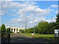
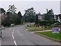
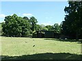
![Brookmans Park Golf Club [1] in AL9 7AT](https://images.propbar.co.uk/images/geograph/71/86/7186825_120.jpg)
Area Information
Living in AL9 7AT means being part of a compact, residential cluster in Hertfordshire, just north of London. The postcode covers 7.7 hectares, housing 1,715 people with a population density of 928 per square kilometre. This is a small, tightly knit area where daily life is shaped by proximity to nearby villages like North Mymms, known for its historic estates and rural charm. The community is largely composed of middle-aged adults, with a median age of 47, reflecting a mature, stable demographic. Ownership is high, with 84% of homes occupied by their owners, suggesting a long-term presence of residents. The area’s character is defined by its mix of traditional housing and proximity to transport links, offering a balance between suburban comfort and easy access to London. While small in size, AL9 7AT sits within a region rich in history, including the Elizabethan North Mymms Park, which adds cultural depth to the local environment. For those seeking a quiet, established community with a touch of heritage, this postcode offers a blend of practicality and historical interest.
- Area Type
- Postcode
- Area Size
- 7.7 hectares
- Population
- 1715
- Population Density
- 928 people/km²
The property market in AL9 7AT is characterised by high home ownership, with 84% of properties occupied by their owners. This suggests a stable, long-term market with limited rental activity, making it a less dynamic area for investors. The accommodation type is predominantly houses, reflecting a suburban or semi-rural setting where larger, private properties are the norm. Given the area’s small size—just 7.7 hectares—there is a limited number of homes available, which may contribute to a competitive market for buyers. The focus on owner-occupied housing indicates that residents are likely to have established roots in the area, reducing the turnover of properties. For prospective buyers, this means a potential emphasis on quality, well-maintained homes rather than speculative investment. The proximity to transport links, such as nearby railway stations, also adds to the area’s appeal, balancing the appeal of a quiet residential environment with practical connectivity to London and surrounding regions.
House Prices in AL9 7AT
Showing 2 properties
| Address | Type | Beds | Baths | Last Sale Price | Last Sale Date | |
|---|---|---|---|---|---|---|
| The Stewards Flat, Brookmans Park Golf Club, Golf Club Road, Brookmans Park, AL9 7AT | Flat | - | - | - | - | |
| Kitchen Flat, Brookmans Park Golf Club, Golf Club Road, Brookmans Park, AL9 7AT | Flat | - | - | - | - |
Energy Efficiency in AL9 7AT
The lifestyle in AL9 7AT is shaped by its proximity to essential amenities and a mix of retail and transport options. Nearby, residents can access five retail outlets, including Co-op Brookmans, Tesco Potters, and Sainsburys Potters, ensuring everyday shopping needs are met. The presence of multiple railway stations, such as Brookmans Park and Potters Bar, and metro stops like High Barnet, provides easy access to London and surrounding areas, supporting both commuting and leisure travel. While the data does not specify parks or recreational facilities, the area’s connection to North Mymms—home to North Mymms Park—suggests opportunities for outdoor activities nearby. The compact nature of AL9 7AT means amenities are within walking or short driving distance, fostering a convenient, community-focused lifestyle. This blend of practical retail, transport, and potential green spaces makes the area appealing for those seeking a balanced mix of suburban comfort and accessibility.
Amenities
Schools
Residents of AL9 7AT have access to a range of educational institutions, including Brookmans Park Primary School, which holds a ‘good’ Ofsted rating. This school is a primary institution, offering early years and foundational education. In addition, Chancellor’s School is listed twice in the data: once as a primary school and once as an academy, though no further details are provided. The presence of both primary and academy schools suggests a diverse educational landscape, catering to different needs and preferences. For families, this mix may provide options for both state and possibly specialist education, depending on the school’s focus. However, the absence of secondary school data means the full educational spectrum is not fully detailed. The proximity of these schools to the area indicates that families can expect a reasonable commute, though specific distances are not provided. The quality of Brookmans Park Primary School, in particular, may be a significant draw for families prioritising strong early education.
| Rank | School | Type | Entry gender | Ages |
|---|
Explore more schools in this area
Go to Schools tabDemographics
The demographic profile of AL9 7AT reflects a mature, settled population. The median age of 47 indicates a community largely composed of adults aged 30–64, with a strong presence of middle-aged households. Home ownership is exceptionally high at 84%, suggesting a preference for long-term residency over rental properties. The area is dominated by houses rather than flats, aligning with the typical housing stock in rural and semi-rural Hertfordshire. The predominant ethnic group is White, though no specific data on diversity or minority representation is provided. With a population density of 928 people per square kilometre, the area is neither densely packed nor sparsely populated, offering a sense of community without overcrowding. The absence of detailed deprivation metrics means little can be said about economic disparities, but the high home ownership rate and age profile suggest a generally stable, middle-income demographic. This makes AL9 7AT appealing to those seeking a quiet, family-oriented environment with minimal turnover.
Household Size
Accommodation Type
Tenure
Ethnic Group
Religion
Household Composition
Age
Household Deprivation
NS-SEC
Explore more demographic insights in this area
Go to Demographics tabPlanning
Planning Constraints
- Flood RiskPremium
- Ramsar Wetland SitesPremium
- Area of Outstanding Natural BeautyPremium
- Protected Nature ReservePremium
- Protected WoodlandPremium