Area Overview for AL4 9HQ
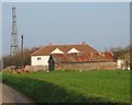
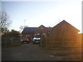
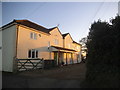
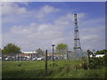
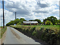
Photos of AL4 9HQ


Area Information
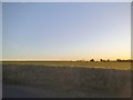
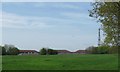
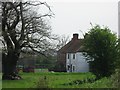
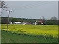
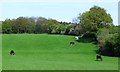
Living in AL4 9HQ means inhabiting a small, tightly knit residential cluster in the St Albans district of Hertfordshire. This area, spanning 7.4 hectares, is home to 1,640 people, translating to a population density of 142 people per square kilometre. Its history is steeped in medieval and monastic heritage, with roots tracing back to the 1086 Domesday Book, when it was known as “Sandruage.” Today, the area blends quiet residential living with accessible transport links, including nearby railway stations and a network of local amenities. Residents benefit from proximity to St Albans, a historic town with cultural and commercial vibrancy, while retaining the charm of a village feel. The area’s compact size means a strong sense of community, with notable features such as St Leonard’s Church, ancient woodlands, and Jersey Farm Woodland Park offering green spaces for leisure. Daily life here balances historical continuity with modern conveniences, making it appealing for those seeking a peaceful yet connected lifestyle.
- Area Type
- Postcode
- Area Size
- 7.4 hectares
- Population
- 1640
- Population Density
- 142 people/km²
AL4 9HQ is a predominantly owner-occupied area, with 64% of homes owned by residents rather than rented. The accommodation type is exclusively houses, reflecting a lack of high-density housing or flats. This small postcode area, covering just 7.4 hectares, suggests a limited number of properties, likely concentrated in established residential clusters. Buyers should expect a modest selection of homes, all of which are likely to be family-sized houses. The absence of rental properties indicates a community focused on long-term residency rather than transient populations. For those considering the area, the compact size means proximity to nearby towns like St Albans, where additional housing options may be available. The market is likely to be competitive, with properties holding value due to their rarity and the area’s historical appeal.
House Prices in AL4 9HQ
No properties found in this postcode.
Energy Efficiency in AL4 9HQ
The lifestyle in AL4 9HQ is defined by a mix of practical retail options and historical natural spaces. Nearby amenities include five retail outlets, such as Tesco St Albans and Budgens Marshalswick, offering everyday shopping needs. The area’s proximity to rail stations enhances access to broader commercial hubs. For leisure, residents can explore Jersey Farm Woodland Park, a 55-acre site of woods and wildflower meadows, and the Jersey Farm adventure playground, a former quarry turned recreational space. St Leonard’s Church, consecrated before 1119 AD, adds a historic dimension to daily life. The blend of green spaces, accessible shopping, and transport links creates a balanced lifestyle, ideal for those valuing both tranquillity and convenience.
Amenities
Schools
The nearest school to AL4 9HQ is Sandridge School, a primary institution with an Ofsted rating of “good.” This rating suggests a reliable standard of education for younger children, though no secondary schools are listed in the data. Families with children may need to look to nearby towns such as St Albans for secondary education options. The presence of a well-regarded primary school is a key draw for families seeking a stable educational environment. The single school type in the area highlights a focus on early education, which may align with the community’s demographic profile of older adults and families with young children. Parents should consider the distance to secondary schools when evaluating the area’s long-term suitability for their needs.
| Rank | School | Type | Entry gender | Ages |
|---|
Explore more schools in this area
Go to Schools tabDemographics
The community in AL4 9HQ is predominantly composed of adults aged 30–64, with a median age of 47. Home ownership is high at 64%, reflecting a stable, long-term resident base. The area is primarily occupied by houses, with no significant presence of flats or other accommodation types. The predominant ethnic group is White, aligning with broader regional trends. The population density of 142 people per square kilometre suggests a low-pressure, spacious living environment. This demographic profile indicates a mature, settled community with limited generational turnover. The absence of specific data on deprivation or diversity metrics means the area likely maintains a consistent socioeconomic profile, though further local studies could provide deeper insights into household income or social mobility.
Household Size
Accommodation Type
Tenure
Ethnic Group
Religion
Household Composition
Age
Household Deprivation
NS-SEC
Explore more demographic insights in this area
Go to Demographics tabPlanning
Planning Constraints
- Flood RiskPremium
- Ramsar Wetland SitesPremium
- Area of Outstanding Natural BeautyPremium
- Protected Nature ReservePremium
- Protected WoodlandPremium