Area Overview for AL3 4HD
Photos of AL3 4HD


Area Information
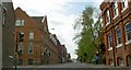
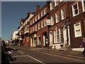
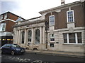
Living in AL3 4HD places you within Verulam Ward, a specific postcode cluster on the northwestern suburban edge of St Albans. This small residential zone spans just 1.1 hectares yet accommodates a population of 2,017 people, resulting in a density of 1,657 people per square kilometre. The area forms part of the historic city centre, originally linked to the ancient Roman town of Verulamium. You are located near Verulam House, a Grade II listed early 19th-century building that has served various roles from a coaching inn to a nursing home. Remnants of Roman Verulamium walls and the Verulamium Museum in adjacent Verulamium Park are situated nearby. Transport links rely on Verulam Road, which was part of Thomas Telford's 1826 post road connecting London to Holyhead. The nearest railway station is St Albans City, located approximately 1 to 2 kilometres to the southeast. This proximity to the historic city centre means daily commutes and access to the ancient site of Saint Alban's martyrdom are easily managed.
- Area Type
- Postcode
- Area Size
- 1.1 hectares
- Population
- 2017
- Population Density
- 1657 people/km²
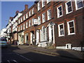
The property market in AL3 4HD is characterised by a strong preference for house ownership. With 72% of residents owning their homes, this is distinctly an owner-occupied area rather than a rental hub. The accommodation type is predominantly houses, meaning you will typically find detached or semi-detached family homes rather than flats or converted apartments. This concentration of single-family dwellings creates a neighbourhood feel typical of the northwestern suburbs of St Albans. The small area size of 1.1 hectares limits large-scale development, preserving the current housing stock. Buyers looking for starter homes or downsizing options may find opportunities, though the high ownership rate implies many properties are already settled hands. The history of the area, traced back to pre-Roman Verlamion and rebuilt after Boudicca's sack, adds value to the existing stock. Even now, properties retain a connection to the historic Verulam House and the Roman walls. Expect a market driven by established families rather than transient tenants or investors.
House Prices in AL3 4HD
Showing 1 properties
| Address | Type | Beds | Baths | Last Sale Price | Last Sale Date | |
|---|---|---|---|---|---|---|
| Abbey Gate House, 4 Abbey Mill Lane, St Albans, AL3 4HD | Detached | - | - | - | - |
Energy Efficiency in AL3 4HD
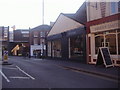
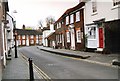
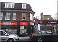
Life in AL3 4HD offers convenience through nearby amenities within practical reach of residents. There are five retail outlets available, including a Co-op on the street, M&S on the street, and a Tesco on the street, providing everyday shopping necessities. For those who prefer walking to services, there are also five railway stations close by, including St Albans Abbey, St Albans City, and Park Street stations. These retail and transport hubs are integrated into the daily routine of Verulam Ward. The area benefits from being on the northwestern edge of St Albans, placing you close to the city centre while maintaining a suburban setting. You can access diverse dining options and leisure facilities that serve the wider city population. The presence of Verulam House and the nearby Verulamium Museum offers cultural and historical leisure activities. This blend of practical retail and cultural heritage defines the local lifestyle.
Amenities
Schools
Families considering homes in AL3 4HD are supported by a strong selection of educational institutions nearby. The nearest state school is The Abbey Church of England Voluntary Aided Primary School in St Albans, which holds an Ofsted rating of good. For independent education, there are three notable options close by. St Columba's College provides secondary education as an independent school. St Columba's Preparatory School caters to younger children as an independent institution. St Albans School is another prominent independent option serving a broad age range. This mix allows you to choose between state-funded education with a good rating or private schooling with established reputations. The presence of both primary and secondary options means all school-age children have convenient access to education. You do not need to travel far for schooling, as these institutions are within practical reach of the Verulam Ward postcode. The variety ensures you can match educational choices to your family's specific needs and budget.
| Rank | School | Type | Entry gender | Ages |
|---|
Explore more schools in this area
Go to Schools tabDemographics
The community in AL3 4HD is defined by a mature population with a median age of 47 years. The vast majority of residents fall within the adult age range of 30 to 64 years, indicating a settled demographic rather than young families or students. House ownership is high in this postcode, with 72% of homes owned outright or with a mortgage. The remaining residents are primarily renting accommodation. The area consists almost entirely of houses rather than flats or apartments, reflecting the suburban character of Verulam Ward. The predominant ethnic group is White, which aligns with the broader demographic trends of Hertfordshire. Living here offers stability for those who prefer established neighbourhoods where long-term residents form the local backbone. The high ownership rate suggests a community invested in maintaining their properties and local streetscapes. You will find a quiet environment dominated by domestic architecture and residential usage.
Household Size
Accommodation Type
Tenure
Ethnic Group
Religion
Household Composition
Age
Household Deprivation
NS-SEC
Explore more demographic insights in this area
Go to Demographics tabPlanning
Planning Constraints
- Flood RiskPremium
- Ramsar Wetland SitesPremium
- Area of Outstanding Natural BeautyPremium
- Protected Nature ReservePremium
- Protected WoodlandPremium