Area Overview for Withern & Theddlethorpe Ward
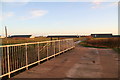
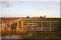
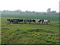
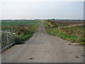
Photos of Withern & Theddlethorpe Ward


Area Information
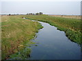
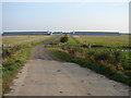
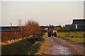
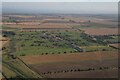
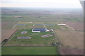
Living in Withern & Theddlethorpe Ward offers a distinctly rural experience within East Lindsey district. This electoral ward spans 91.4 km² and contains the villages of Withern and Theddlethorpe, the latter including Theddlethorpe St Helen. Situated near the Lincolnshire coast at coordinates 53.3337°N, 0.1674°E, the area sits firmly in the East Midlands region of England. You will find yourself in a setting defined by its coastal location and village character rather than urban sprawl. The geography includes significant natural features that shape daily life, with the ward containing protected nature reserves and protected woodland alongside Ramsar wetland sites. These planning constraints indicate a landscape of high conservation value where development is naturally limited. This geographical reality defines the quiet, expansive feel of the neighbourhood. Residents enjoy proximity to the coast, though the rural nature means services are concentrated in the local villages. The area is not adjacent to major cities or large town centres, which influences travel times and lifestyle choices. If you are looking for a home surrounded by open space and natural features, this ward delivers on those terms. However, the presence of wetlands and nature reserves also means you must consider specific planning restrictions if you plan future modifications to new homes in Withern & Theddlethorpe Ward.
- Area Type
- District Borough Unitary Ward
- Area Size
- 91.4 km²
- Population
- Not available
- Population Density
- Not available
Demographics
The community living in Withern & Theddlethorpe Ward skews significantly towards older residents. The median age here is 70 years old, marking this as a retirement-oriented or mature kampung compared to national averages. This age profile suggests a population that has settled down and likely values stability and peace over rapid urban change. Home ownership stands at 81 per cent of the total population. Such a high rate indicates that most people have purchased their current homes rather than renting. This stability contributes to a long-term resident base that knows the area well. The household composition and overall accommodation type data reflect this settled society. Ethnically, the area is predominantly representative of the local demographic trends typical of rural Lincolnshire, although specific breakdown figures are not detailed in the current dataset. Similarly, while religion and specific household types form part of the area research, the core fact remains that the population is largely composed of older, owner-occupying families. This demographic makes little sense for young families seeking nearby schools or diverse social hubs, as the typical resident age is far beyond child-rearing years. Instead, the area caters to retirees or downsizers looking for a quiet life. When evaluating who lives in Withern & Theddlethorpe Ward, you are primarily joining a mature community where longevity and property ownership are the norm.
Household Size
Accommodation Type
Tenure
Ethnic Group
Religion
Household Composition
Age
Household Deprivation
NS-SEC
Explore more demographic insights in this area
Go to Demographics tabPlanning
Planning Constraints
- Flood RiskPremium
- Ramsar Wetland SitesPremium
- Area of Outstanding Natural BeautyPremium
- Protected Nature ReservePremium
- Protected WoodlandPremium
- Crime RiskPremium