Area Overview for Wigston All Saints Ward
Photos of Wigston All Saints Ward


Area Information
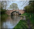
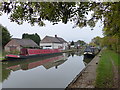
Living in Wigston All Saints Ward offers a distinct experience within the Oadby and Wigston borough. This district council ward covers an area of 2.6 km² and sits within the historic Wigston Magna district. You are positioned south-east of Leicester city centre, placing you firmly inside the Leicester urban area. The ward takes its name from All Saints Church, a defining landmark that anchors the community. Historical street names and features reflect the area's deep roots. Kilby Gate preserves a pathway from Wigston to Kilby dating from approximately 1500, while Gaol Close marks a paddock on Long Lane formerly used as a temporary gaol during the siege of Leicester. Daily life here is shaped by significant architectural and historical elements. The Green serves as a central green space at the junction of Bulls and Cross Street. Peace Memorial Park, located on the site of the former Gaol Close, provides a further notable feature for residents. The Midland Main Line railway traverses the ward, crossing the district boundary. The former Wigston Station, now closed, was historically accessible via Station Road. Several streets bear names from the 19th century, including Gladstone Street, which commemorates Prime Minister William Gladstone. The Grand Union Canal also crosses the district boundary, adding another layer to the local landscape. This blend of historical heritage and urban proximity defines the character of Wigston All Saints Ward for anyone considering homes in this location.
- Area Type
- District Borough Unitary Ward
- Area Size
- 2.6 km²
- Population
- Not available
- Population Density
- Not available
Demographics
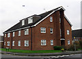
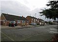
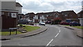
The community in Wigston All Saints Ward has a particularly distinct age profile. The demographic data indicates a median age of 70. This figure suggests that a significant portion of the residents are retired or approaching retirement. You are likely to encounter neighbours who have lived in the area for many decades. The most common age range identified in the available statistics falls under the category of "Age: Total", reflecting this older population structure. This demographic shift means you should expect a quieter, more settled atmosphere compared to districts dominated by families with young children. Home ownership is a dominant feature of the ward. Seventy-seven per cent of residents own their homes outright or with a mortgage. This high level of ownership points to a community where families and individuals invest in long-term stability within Wigston All Saints Ward. Household composition data is recorded as a total, reinforcing the picture of a residential area rather than one focused on transient rentals. While specific details regarding household types or accommodation categories are summarised under headings like "total" and "total", the overarching picture is clear. The area is defined by permanence, with ownership levels standing significantly higher than the national average typically found in younger housing markets. This fact is crucial for anyone researching schools near Wigston All Saints Ward or considering the long-term viability of their investment.
Household Size
Accommodation Type
Tenure
Ethnic Group
Religion
Household Composition
Age
Household Deprivation
NS-SEC
Explore more demographic insights in this area
Go to Demographics tabPlanning
Planning Constraints
- Flood RiskPremium
- Ramsar Wetland SitesPremium
- Area of Outstanding Natural BeautyPremium
- Protected Nature ReservePremium
- Protected WoodlandPremium
- Crime RiskPremium