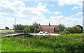
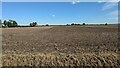
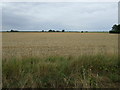
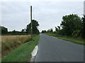
Area Overview for Thornton Le Fen
Photos of Thornton Le Fen


Area Information
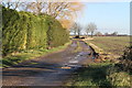
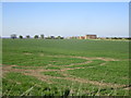
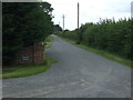
Living in Thornton Le Fen offers a distinct lifestyle within a civil parish that covers exactly 6.8 km². This is a small, defined community where daily life moves at a deliberate pace, far removed from the congestion found in larger urban centres. You will find that the area is settled enough to offer specific local character yet small enough that neighbours often know one another by name. The Parish acts as a self-contained unit where the limitations of its size define the rhythm of residence. You do not just visit Thornton Le Fen; it accommodates your routine entirely. The landscape here is gentle, noted by the lack of protected nature reserves or designated Areas of Outstanding Natural Beauty, which means the planning landscape remains relatively straightforward compared to stricter conservation zones. For prospective buyers, the setting is characterised by its absolute scale. The entire parish is a compact 6.8 km², ensuring that all amenities fall within a very short drive or walk. This geographical concentration means you spend less time commuting within this specific jurisdiction and more time enjoying the immediate surroundings. The community feels established and unchanging, holding steady regardless of broader regional shifts. As you explore homes in Thornton Le Fen, you are entering an environment where the boundaries are clear and the sense of place is anchored by its modest dimensions. It is a location defined by its quiet presence rather than by rapid development or dramatic changes in infrastructure.
- Area Type
- Parish
- Area Size
- 6.8 km²
- Population
- Not available
- Population Density
- Not available
Demographics
The community in Thornton Le Fen presents a clear demographic picture dominated by older residents. The median age stands at exactly 70, indicating that half the population is over this age. This profile suggests that Thornton Le Fen is primarily a retirement destination or a place where families have moved in support of elderly relatives. Age ranges in the area are not afforded granular breakdown in the available records, but the central tendency clearly points to a mature demographic. You should anticipate seeing a resident base that values stability, quiet streets, and a settled neighbourhood atmosphere. Home ownership in Thornton Le Fen is prevalent, with 77% of households owning their property outright or with a mortgage. This high rate of ownership indicates that long-term residents have significant stake in the community. The remaining 23% likely consist of renters or those living with relatives, a figure that aligns perfectly with the older population average. Household composition data aggregates all types without distinguishing between singles, couples, or families, yet the high ownership rate strongly implies that many homes in Thornton Le Fen are family units or couples living independently. There is no specific data on ethnic diversity or religious breakdown in the current records, so the community feels defined more by its age profile than by cultural trends. Living in Thornton Le Fen means joining a cohort that expects a quieter, more traditional pace of life.
Household Size
Accommodation Type
Tenure
Ethnic Group
Religion
Household Composition
Age
Household Deprivation
NS-SEC
Explore more demographic insights in this area
Go to Demographics tabPlanning
Planning Constraints
- Flood RiskPremium
- Ramsar Wetland SitesPremium
- Area of Outstanding Natural BeautyPremium
- Protected Nature ReservePremium
- Protected WoodlandPremium
- Crime RiskPremium