Area Overview for Sutton St Edmund
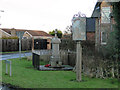
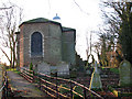
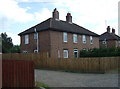
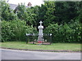
Photos of Sutton St Edmund


Area Information
Living in Sutton St Edmund offers a distinct blend of compact urban living and practical convenience. Covering 28.6 hectares, this built-up area in England is home to a population with a median age of 70, reflecting a community that values stability and familiarity. The area’s proximity to major retail hubs such as Morrisons Daily Gedney, Asda Wisbech, and Tesco Wisbech ensures daily essentials are within easy reach. With 79% of residents owning their homes, the neighbourhood has a strong sense of permanence. While the area is small, its amenities are well-located, making it practical for those who prioritise accessibility over sprawling landscapes. Sutton St Edmund is not a place for those seeking a fast-paced lifestyle, but it suits those who appreciate a quiet, established environment with minimal commute demands. The low crime risk further reinforces its appeal as a secure, low-stress location. For buyers seeking a straightforward, well-maintained property in a mature community, Sutton St Edmund provides a clear, no-frills alternative to more dynamic urban areas.
- Area Type
- Built Up Area 250
- Area Size
- 28.6 hectares
- Population
- Not available
- Population Density
- Not available
Residents of Sutton St Edmund have access to essential retail amenities within practical reach, including Morrisons Daily Gedney, Asda Wisbech, and Tesco Wisbech. These stores provide a range of groceries, household goods, and services, reducing the need for long commutes to larger centres. While the area lacks detailed data on dining or leisure options, the presence of major supermarkets indicates a focus on convenience. The compact size of Sutton St Edmund (28.6 hectares) means amenities are closely clustered, making daily errands efficient. For those who enjoy a walkable environment with essential services nearby, the area offers a straightforward lifestyle. However, the absence of specific data on parks or cultural venues means its recreational offerings remain unclear, though the proximity to nearby towns may compensate for this.
Amenities
Schools
| Rank | School | Type | Entry gender | Ages |
|---|
Explore more schools in this area
Go to Schools tabDemographics
Sutton St Edmund’s population is defined by its median age of 70, the highest in the dataset, indicating a community skewed towards older residents. This age profile shapes the area’s character, with a focus on stability and long-term residency. Home ownership is high, at 79%, suggesting that most residents are settled in their properties rather than renting. The data does not specify household composition or accommodation types, but the overall figures imply a mix of family and single-person households. The absence of detailed breakdowns on ethnicity or religion means the area’s diversity remains unquantified, though the figures provided confirm a homogenous demographic structure. For those considering a move, the high home ownership rate and older population suggest a quiet, mature environment where community ties are likely to be long-standing.
Household Size
Accommodation Type
Tenure
Ethnic Group
Religion
Household Composition
Age
Household Deprivation
NS-SEC
Explore more demographic insights in this area
Go to Demographics tabPlanning
Planning Constraints
- Crime RiskPremium