Area Overview for South Normanton East Ward
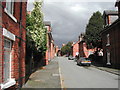
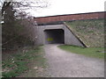
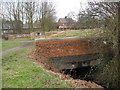
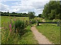
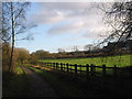
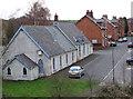
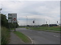
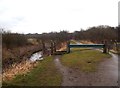
Photos of South Normanton East Ward


Area Information
Living in South Normanton East Ward offers a distinct character within Derbyshire. This ward occupies just 2.7 km², making it a compact neighbourhood where daily amenities are within easy reach. The area is dominated by retirees, as the median age of residents sits at an impressive 70 years old. This demographic skew creates a quiet, settled atmosphere that contrasts with busier urban centres. You will find that the community is stabilised by a strong sense of history and local tradition. There are no large commercial redevelopments or major infrastructure projects planned that might alter the landscape quickly. Instead, the focus remains on preserving the existing residential fabric. The small footprint means that travel between the centre of the ward and its boundaries takes only moments. [section 2] The community in South Normanton East Ward is defined by an unusually mature population. With a median age of 70, the area functions as a retirement hub for the surrounding region. Most residents fall into older age brackets, reflecting a life stage focused on leisure and stability rather than raising families. Home ownership is the norm, with 68% of houses in South Normanton East Ward owned outright or with a mortgage. This high rate of ownership suggests long-term residents who have put down deep roots in the locality. Household composition aligns with this demographic, featuring primarily single-person or couple-only households without children. Accommodation types mirror the needs of this age group, prioritising accessible living spaces. The ward contains no significant pockets of deprivation that would impact daily quality of life. Diversity data indicates that the predominant ethnic group is white British, which aligns with the broader demographic structure of the region. Religion statistics do not show a dominant单一的 faith cluster, suggesting a secular or mixed congregation approach to worship. These factors combine to create a predictable, low-maintenance environment. You will find neighbours who likely value peace and quiet above all else. The social dynamic is built on decades of established friendship networks rather than transient interactions. [section 3] The property market in South Normanton East Ward is characterised by stable occupancy and established housing stock. A striking 68% of the occupied dwellings are in the hands of owners rather than tenants. This statistic indicates that temporary rentals are rare within these boundaries. You are more likely to purchase a home here than rent one, as the market caters to long-term stability. The low volume of 2.7 km² means that available homes in South Normanton East Ward appear infrequently. When properties do come onto the market, they tend to move quickly due to the consistent demand from local retirees. Although specific accommodation type breakdowns are not detailed in the available figures, the ownership rate strongly implies traditional detached or semi-detached family homes converted for retirement use. The absence of large-scale student accommodation or high-density blocks reinforces the residential nature of the ward. Buyers looking at South Normanton East Ward should expect a classic suburban setting rather than a transient estate. The high ownership rate suggests low vacancy rates, meaning competition for specific properties can be fierce. It is advisable to act swiftly when a suitable home in this small ward becomes available. The market here rewards those who know exactly what they want before viewing begins. patience is required, but the security of ownership is a major draw. Digital connectivity in South Normanton East Ward is exceptional, ensuring residents stay fully connected. The fixed broadband quality score reaches 99 out of 100, placing the ward among the fastest-connecting areas in the entire country. This rating means you will experience lightning-fast internet speeds suitable for heavy downloading or working from home without interruption. Mobile coverage is robust, providing reliable service even in rural pockets of the neighbourhood. Such high-speed infrastructure makes this an ideal location for remote professionals or anyone reliant on constant digital access. The connectivity scores far exceed national averages, removing any concerns about bandwidth limitations. Safety and environmental considerations for South Normanton East Ward present a mixed picture that requires balanced consideration. The environment is largely protected from natural disasters. Flood risk assessment shows a low risk level with a score of 1.59, indicating that standard precautions are usually sufficient. There is no coverage of Ramsar wetland sites, Areas of Outstanding Natural Beauty, or protected woodlands within the ward boundaries. This means planning constraints related to wilderness preservation are non-existent, allowing for straightforward maintenance of the landscape. However, crime risk presents a more significant factor for daily living. The crime risk level is medium, with a score of 61 out of 100 where lower scores indicate less risk. This rating suggests that crime rates are around the national average. You will not face exceptional safety threats, but standard security precautions remain advisable. Locks should be sturdy, and lighting on pathways should be adequate. While the natural environment is safe from flooding or planning restrictions like protected reserves, vigilance regarding personal property is wise. The overall safety picture allows for comfortable living, provided residents remain alert to the medium crime levels typical of this demographic area. Is South Normanton East Ward suitable for families with young children?South Normanton East Ward has a median age of 70, meaning the population is heavily skewed towards retirees. Only 32% of households are rented, while 68% are owner-occupied, which points to a stable, older community. The ward's quiet nature and lack of amenities specifically designed for younger families may make it less suitable for active childhoods. What is the broadband situation for remote workers in this area?Residents can expect top-tier internet performance. The fixed broadband quality score is 99, making it one of the fastest locations in the UK. This ensures reliable video calls and work access without interruption. You will not experience the connectivity issues often found in rural English neighbourhoods here. How safe is South Normanton East Ward for evening walks?The area carries a medium crime risk warning with a score of 61 out of 100. This indicates crime rates are around the national average. Standard security measures like secure doors and window locks are recommended. While the environment is not dangerous compared to high-risk zones, you should maintain standard vigilance after dark. Is the ward prone to flooding or planning restrictions?You can rest easy regarding environmental constraints. The area has a low flood risk score of 1.59 and contains no Ramsar sites, Areas of Outstanding Natural Beauty, or protected woodlands. This freedom from planning constraints and flood fears makes the land highly manageable for future maintenance.
- Area Type
- District Borough Unitary Ward
- Area Size
- 2.7 km²
- Population
- Not available
- Population Density
- Not available
Demographics
The community in South Normanton East Ward is defined by an unusually mature population. With a median age of 70, the area functions as a retirement hub for the surrounding region. Most residents fall into older age brackets, reflecting a life stage focused on leisure and stability rather than raising families. Home ownership is the norm, with 68% of houses in South Normanton East Ward owned outright or with a mortgage. This high rate of ownership suggests long-term residents who have put down deep roots in the locality. Household composition aligns with this demographic, featuring primarily single-person or couple-only households without children. Accommodation types mirror the needs of this age group, prioritising accessible living spaces. The ward contains no significant pockets of deprivation that would impact daily quality of life. Diversity data indicates that the predominant ethnic group is white British, which aligns with the broader demographic structure of the region. Religion statistics do not show a dominant单一的 faith cluster, suggesting a secular or mixed congregation approach to worship. These factors combine to create a predictable, low-maintenance environment. You will find neighbours who likely value peace and quiet above all else. The social dynamic is built on decades of established friendship networks rather than transient interactions. [section 3] The property market in South Normanton East Ward is characterised by stable occupancy and established housing stock. A striking 68% of the occupied dwellings are in the hands of owners rather than tenants. This statistic indicates that temporary rentals are rare within these boundaries. You are more likely to purchase a home here than rent one, as the market caters to long-term stability. The low volume of 2.7 km² means that available homes in South Normanton East Ward appear infrequently. When properties do come onto the market, they tend to move quickly due to the consistent demand from local retirees. Although specific accommodation type breakdowns are not detailed in the available figures, the ownership rate strongly implies traditional detached or semi-detached family homes converted for retirement use. The absence of large-scale student accommodation or high-density blocks reinforces the residential nature of the ward. Buyers looking at South Normanton East Ward should expect a classic suburban setting rather than a transient estate. The high ownership rate suggests low vacancy rates, meaning competition for specific properties can be fierce. It is advisable to act swiftly when a suitable home in this small ward becomes available. The market here rewards those who know exactly what they want before viewing begins. patience is required, but the security of ownership is a major draw. Digital connectivity in South Normanton East Ward is exceptional, ensuring residents stay fully connected. The fixed broadband quality score reaches 99 out of 100, placing the ward among the fastest-connecting areas in the entire country. This rating means you will experience lightning-fast internet speeds suitable for heavy downloading or working from home without interruption. Mobile coverage is robust, providing reliable service even in rural pockets of the neighbourhood. Such high-speed infrastructure makes this an ideal location for remote professionals or anyone reliant on constant digital access. The connectivity scores far exceed national averages, removing any concerns about bandwidth limitations. Safety and environmental considerations for South Normanton East Ward present a mixed picture that requires balanced consideration. The environment is largely protected from natural disasters. Flood risk assessment shows a low risk level with a score of 1.59, indicating that standard precautions are usually sufficient. There is no coverage of Ramsar wetland sites, Areas of Outstanding Natural Beauty, or protected woodlands within the ward boundaries. This means planning constraints related to wilderness preservation are non-existent, allowing for straightforward maintenance of the landscape. However, crime risk presents a more significant factor for daily living. The crime risk level is medium, with a score of 61 out of 100 where lower scores indicate less risk. This rating suggests that crime rates are around the national average. You will not face exceptional safety threats, but standard security precautions remain advisable. Locks should be sturdy, and lighting on pathways should be adequate. While the natural environment is safe from flooding or planning restrictions like protected reserves, vigilance regarding personal property is wise. The overall safety picture allows for comfortable living, provided residents remain alert to the medium crime levels typical of this demographic area. Is South Normanton East Ward suitable for families with young children?South Normanton East Ward has a median age of 70, meaning the population is heavily skewed towards retirees. Only 32% of households are rented, while 68% are owner-occupied, which points to a stable, older community. The ward's quiet nature and lack of amenities specifically designed for younger families may make it less suitable for active childhoods. What is the broadband situation for remote workers in this area?Residents can expect top-tier internet performance. The fixed broadband quality score is 99, making it one of the fastest locations in the UK. This ensures reliable video calls and work access without interruption. You will not experience the connectivity issues often found in rural English neighbourhoods here. How safe is South Normanton East Ward for evening walks?The area carries a medium crime risk warning with a score of 61 out of 100. This indicates crime rates are around the national average. Standard security measures like secure doors and window locks are recommended. While the environment is not dangerous compared to high-risk zones, you should maintain standard vigilance after dark. Is the ward prone to flooding or planning restrictions?You can rest easy regarding environmental constraints. The area has a low flood risk score of 1.59 and contains no Ramsar sites, Areas of Outstanding Natural Beauty, or protected woodlands. This freedom from planning constraints and flood fears makes the land highly manageable for future maintenance.
Household Size
Accommodation Type
Tenure
Ethnic Group
Religion
Household Composition
Age
Household Deprivation
NS-SEC
Explore more demographic insights in this area
Go to Demographics tabPlanning
Planning Constraints
- Flood RiskPremium
- Ramsar Wetland SitesPremium
- Area of Outstanding Natural BeautyPremium
- Protected Nature ReservePremium
- Protected WoodlandPremium
- Crime RiskPremium