Area Overview for South Normanton
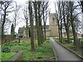
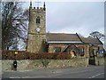
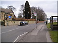
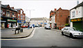
Photos of South Normanton


Area Information
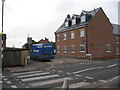
South Normanton is a compact built-up area in England, covering 4.3 km², with a population profile that reflects a mature demographic. The median age of 70 suggests a community shaped by long-term residents, many of whom may have lived in the area for decades. This is a town where daily life is rooted in familiarity, with a strong emphasis on local amenities and established networks. The area’s home ownership rate of 71% indicates a stable housing market, with many residents choosing to stay put. Proximity to schools, retail hubs, and rail links makes it practical for families and commuters. While the population size is not specified, the presence of five nearby schools and multiple retail outlets suggests a well-served community. South Normanton’s character is defined by its balance of practicality and quiet living, with infrastructure that supports both routine needs and occasional outings. For those seeking a place with a slower pace and strong local ties, this area offers a distinct alternative to more densely populated urban centres.
- Area Type
- Built Up Area 250
- Area Size
- 4.3 km²
- Population
- Not available
- Population Density
- Not available
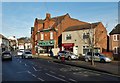
South Normanton’s lifestyle is shaped by its accessible amenities and community-focused environment. Nearby retail outlets include Heron Hilcote, Morrisons Daily, and Co-op South, offering everyday shopping needs within walking or short driving distance. These stores cater to a range of preferences, from local groceries to larger supermarket chains. The area’s rail stations—Alfreton, Kirkby in Ashfield, and Sutton Parkway—connect residents to broader networks, enabling trips to cultural, leisure, or professional opportunities beyond the immediate neighbourhood. While parks and leisure facilities are not explicitly listed, the presence of multiple schools and retail hubs suggests a community that values practicality and social interaction. The combination of shops, transport links, and a low crime risk contributes to a lifestyle that prioritises convenience and safety for residents.
Amenities
Schools
South Normanton is served by five schools, including nurseries and primary institutions. South Normanton Nursery School provides early education, while The Green Infant School and Frederick Gent School cater to younger primary students. Two primary schools—The Brigg Infant School and Glebe Junior School—have Ofsted ratings of “good,” indicating effective teaching and management. This mix of school types ensures families have options for early years education and primary schooling. The presence of multiple schools within the area suggests a focus on local education, reducing the need for long commutes. For parents prioritising school quality, the “good” ratings at two primary schools offer reassurance about educational standards. The proximity of these schools to residential areas also supports a community-oriented lifestyle, where children can walk or be driven short distances to school.
| Rank | School | Type | Entry gender | Ages |
|---|---|---|---|---|
| 1 | South Normanton Nursery School | nursery | N/A | N/A |
| 2 | The Green Infant School | primary | N/A | N/A |
| 3 | The Brigg Infant School | primary | N/A | N/A |
| 4 | Glebe Junior School | primary | N/A | N/A |
| 5 | Frederick Gent School | primary | N/A | N/A |
Explore more schools in this area
Go to Schools tabDemographics
South Normanton’s population has a median age of 70, the highest recorded in the data, indicating a community skewed towards older adults. The most common age range is listed as “Age: Total,” which may reflect aggregated data but underscores the area’s demographic consistency. With 71% of homes owner-occupied, the majority of residents are long-term homeowners, suggesting a stable and settled population. Household composition and accommodation types are noted as “total,” but the high home ownership rate implies a mix of family homes and single-occupancy properties. Deprivation data is not provided, but the presence of five retail outlets and multiple rail stations within practical reach suggests reasonable access to essential services. The area’s safety score of 67 (low risk) further supports a quality of life that prioritises security and stability for its residents.