Area Overview for South Leverton
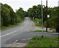
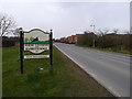
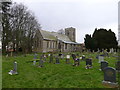
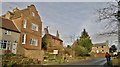
Photos of South Leverton


Area Information
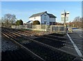
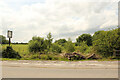
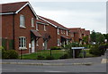
South Leverton is a compact built-up area spanning 42.8 hectares, nestled in England’s heartlands. Its population, while not explicitly stated, is reflected in its demographics: a median age of 70 suggests a community skewed toward older residents, many of whom likely own their homes, with 80% of properties in private hands. Daily life here is shaped by proximity to essential services. The area’s retail options include Spar, Asda King, and other local stores, while rail links to Gainsborough Lea Road, Retford Low Level, and Retford Railway Stations provide connectivity to nearby towns. A single airport, Retford Gamston, adds accessibility for travel. The presence of Orchard School, an independent institution, hints at a focus on education, though no Ofsted rating is provided. South Leverton’s character is defined by its practical amenities and the quiet rhythm of a community where home ownership is prevalent, and the pace of life is unhurried. For those seeking a stable, low-key environment with essential infrastructure, this area offers a straightforward, no-frills approach to living.
- Area Type
- Built Up Area 250
- Area Size
- 42.8 hectares
- Population
- Not available
- Population Density
- Not available
Daily life in South Leverton is shaped by its accessible amenities. Retail options include multiple Spar stores and Asda King, providing convenience for grocery shopping and everyday needs. The rail network, with stations at Gainsborough Lea Road and Retford, connects residents to broader regional hubs, while Retford Gamston Airport offers a gateway for travel. Though the area lacks detailed data on parks or leisure facilities, the presence of retail and transport links suggests a practical, service-oriented lifestyle. The mix of shops and transport points to a community prioritising accessibility over expansive recreational spaces. For those valuing ease of access to essentials and reliable travel options, South Leverton delivers a straightforward, functional environment.
Amenities
Schools
The nearest school to South Leverton is Orchard School, an independent institution. No Ofsted rating is provided, so its educational quality remains unspecified. The presence of an independent school suggests that families seeking alternative education options have access to at least one private option. However, the absence of state schools in the data means the full range of educational provision is unclear. For families prioritising independent education, Orchard School offers a viable choice, but those requiring state-funded schooling may need to look beyond the immediate area. The single school listed indicates a limited selection, which could be a consideration for parents evaluating the long-term suitability of the area for children’s education.
| Rank | School | Type | Entry gender | Ages |
|---|
Explore more schools in this area
Go to Schools tabDemographics
South Leverton’s population is predominantly older, with a median age of 70, reflecting a community where retirement is the norm. The data shows 80% of residents own their homes, indicating a strong preference for long-term settlement over rental living. Household composition and accommodation types are not detailed, but the high home ownership rate suggests a stable, settled population. The area’s demographic profile lacks specific information on diversity or deprivation, but the absence of such data implies a homogenous community with limited variation in socioeconomic factors. This may translate to a consistent quality of life, though it also raises questions about the range of needs and services catered to. The lack of detailed figures on ethnicity or religion means broader social dynamics remain unexplored, but the existing data underscores a demographic foundation rooted in stability and longevity.
Household Size
Accommodation Type
Tenure
Ethnic Group
Religion
Household Composition
Age
Household Deprivation
NS-SEC
Explore more demographic insights in this area
Go to Demographics tabPlanning
Planning Constraints
- Crime RiskPremium