Area Overview for SK13 9SA
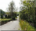
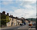
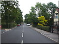
Photos of SK13 9SA


Area Information
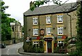
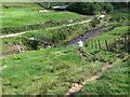
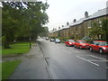
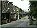
SK13 9SA represents a specific residential cluster in England with a defined population of 1286 people. This small area forms part of the wider Glossop postcode region, situated within Derbyshire. You will find that daily life here revolves around a quiet, settled community character rather than a bustling high street experience. The location is primarily residential, serving as a home for several hundred families and households who value a modest footprint. Because this post code covers a tight-knit group of properties, interactions with neighbours often feel direct and established. The area sits conveniently between major rail hubs like Glossop Railway Station and Dinting Railway Station, ensuring you have easy access to wider transport networks without living in the city centre itself. It is a place where the pace of life slows down, yet essential services remain within practical reach. You can expect a neighbourhood that offers stability and familiarity. The surroundings are dominated by housing stock suitable for owner-occupiers. While you do not find a major town centre immediately within every street, the proximity to Lidl Glossop and Asda Townhouse means you do not need to travel far for weekly shopping. Living in SK13 9SA means accepting a quiet domestic environment in exchange for strong connectivity to retail and transport. The area functions effectively as a bedroom community for those who work in Glossop or further afield.
- Area Type
- Postcode
- Area Size
- Not available
- Population
- 1286
- Population Density
- 1417 people/km²
The property market in SK13 9SA is dominated by houses, which aligns with the preferences of the local residents. Sixty per cent of households own their homes, creating a market characterised by owner-occupiers rather than private landlords. You will find that new developments are less common than established housing stocks, which reinforces the area's quiet reputation. This high ownership rate suggests that sellers typically know their properties well and may price them competitively if they wish to move. The accommodation type is strictly houses, meaning you will not find purpose-built flats or high-rise apartments within this specific postcode. This feature appeals to buyers who value garden space and detached or semi-detached living. Because the area is purely residential, commercial properties are absent from the immediate streets. When looking at homes in SK13 9SA, you should expect traditional architecture suited to the Derbyshire landscape. The small population of 1286 limits the total housing supply, which can influence resale values and market liquidity. Potential buyers might find that chains exist if multiple owners in the cluster wish to sell simultaneously. However, the high ownership percentage also means many owners have lived there for decades and may not be selling soon. This results in a slower market turnover compared to urban centres. For those seeking a rental property, options are likely limited as many landlords have converted to owner-occupier status. The market here rewards patience and realistic expectations regarding house types and pricing.
House Prices in SK13 9SA
No properties found in this postcode.
Energy Efficiency in SK13 9SA
Living in SK13 9SA offers convenient access to essential retail and leisure facilities within a short distance. You will find five notable retail amenities nearby, including Lidl Glossop, Asda Townhouse, and M&S Glossop SF. These supermarkets provide everything from fresh groceries to household essentials. You do not need to drive far to stock up on weekly shopping. Five railway stations serve the local population, including Glossop Railway Station, Dinting Railway Station, and Hadfield Railway Station. These transport links connect you to wider employment hubs. The area lacks dedicated leisure centres or bars immediately on-site, but the nearby high streets provide ample dining and entertainment. You can access cafes, restaurants, and cinemas in the surrounding towns. The lifestyle here is practical and focused on utility rather than nightlife. Residents value the ability to shop at Asda Townhouse without a lengthy commute. The proximity to five retail options ensures that day-to-day needs are met without significant disruption. Parks and green spaces are not explicitly listed in the immediate amenity data, but the residential house stock often includes private gardens. The character of the area is defined by its relationship with the town centres rather than standalone facilities. Convenience drives the lifestyle, with most activities occurring within a fifteen-minute drive. This setup suits families who prioritise time over leisure venues.
Amenities
Schools
| Rank | School | Type | Entry gender | Ages |
|---|
Explore more schools in this area
Go to Schools tabDemographics
The community in SK13 9SA reflects a settled demographic where adults typically form the core of the population. The median age sits at 47 years, indicating that the area is not dominated by young families or retirees. Most residents fall into the 30 to 64 years age bracket, suggesting a workforce-oriented group who may have children or be nearing retirement. You will find that home ownership stands at 60 per cent, meaning nearly two out of three households own their property outright or have a mortgage. This high percentage creates a stable community where residents are likely to put down roots. The predominant accommodation type consists of houses rather than flats, catering to families or couples seeking space. Ethnic diversity is low, with White residents forming the predominant group. This homogeneity often contributes to a predictable social environment where local customs remain consistent. You should note that the population of 1286 is relatively small, which means street parties or community events generate noticeable local excitement. There are no large transient populations or student housing concentrations here. The area does not experience the rapid turnover common in student zones. Instead, residents tend to stay for years. This stability affects local schools near SK13 9SA, as families seek consistency in their children's education. The age profile ensures that local demand focuses on家庭-sized homes rather than single-person units or purpose-build apartments.
Household Size
Accommodation Type
Tenure
Ethnic Group
Religion
Household Composition
Age
Household Deprivation
NS-SEC
Explore more demographic insights in this area
Go to Demographics tabPlanning
Planning Constraints
- Flood RiskPremium
- Ramsar Wetland SitesPremium
- Area of Outstanding Natural BeautyPremium
- Protected Nature ReservePremium
- Protected WoodlandPremium