Area Overview for S41 9EA
Photos of S41 9EA


Area Information
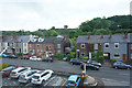
S41 9EA occupies a compact residential cluster spanning 7.9 hectares within Chesterfield. This specific postcode covers a small population of 1,559 people, creating a tightly knit community where residents know one another. The area is defined by its dense but manageable scale, supporting 425 people per square kilometre. You live in a setting that prioritises established neighbourhood character over rapid expansion. Daily life revolves around a close-knit environment where distances to key services remain short. The housing stock consists entirely of houses, reflecting a traditional suburban settlement pattern rather than high-density urban living. This consistency in property type means you do not encounter the sudden transitions between flats and detached homes common in larger cities. Instead, the streets of S41 9EA offer a uniform residential experience. The small size of the area means that noise from traffic or industry is unlikely to dominate the soundscape. You enjoy a sense of space despite the higher population density figures relative to the physical land area. The community feels secure and well-defined, catering primarily to those who value a settled environment.
- Area Type
- Postcode
- Area Size
- 7.9 hectares
- Population
- 1559
- Population Density
- 425 people/km²
Homes in S41 9EA are defined by a singular architectural tradition. The accommodation type is exclusively houses, meaning you will not find flats or purpose-built apartments within this postcode. This uniformity creates a homogenous streetscape where property values tend to behave predictably based on square footage and land size. The 65 per cent home ownership rate confirms that the market is overwhelmingly owner-occupied. Purchasing a home here means joining a community where the vast majority of neighbours have a vested financial interest in maintaining property standards. There is little incentive for short-term rental turnover, which benefits long-term residents through consistent neighbourhood management. If you are looking for rental options, you will find that the stock is scarce compared to the buyers' market. The size of the area at 7.9 hectares limits the total number of available plots. You are not competing against high-rise developments or luxury complexes. Instead, you are buying into a legacy development where the architectural character remains consistent with the surrounding suburbs of Chesterfield.
House Prices in S41 9EA
Showing 15 properties
| Address | Type | Beds | Baths | Last Sale Price | Last Sale Date | |
|---|---|---|---|---|---|---|
| 183 Broomhill Road, Old Whittington, S41 9EA | Semi-detached | 2 | 1 | £150,000 | Nov 2021 | |
| 177 Broomhill Road, Old Whittington, S41 9EA | Semi-detached | 3 | 1 | £185,000 | Mar 2021 | |
| 185 Broomhill Road, Old Whittington, S41 9EA | house | - | - | £330,000 | Oct 2020 | |
| Copperfield Cottage, Broomhill Road, Old Whittington, S41 9EA | Bungalow | - | - | £235,000 | Sep 2019 | |
| 179 Broomhill Road, Old Whittington, S41 9EA | Detached | - | - | £144,500 | Jan 2004 | |
| 175 Broomhill Road, Old Whittington, S41 9EA | house | 4 | 2 | - | - | |
| 191 Broomhill Road, Old Whittington, S41 9EA | Terraced | - | - | - | - | |
| Broomhioll Farm Ltd, Luxury Dog Hotel, Broomhill Mews, Broomhill Road, Old Whittington, S41 9EA | commercial | - | - | - | - | |
| 181 Broomhill Road, Old Whittington, S41 9EA | house | - | - | - | - | |
| 187 Broomhill Road, Old Whittington, S41 9EA | Detached | - | - | - | - |
Energy Efficiency in S41 9EA
Living in S41 9EA offers direct access to practical amenities without requiring a long drive. Five retail outlets fall within practical reach, ensuring daily shopping needs are met instantly. You can visit Tesco Chesterfield for supermarkets, Lidl Newbold for budget groceries, and Spar for convenience items. Each of these venues sits close enough to become part of your regular weekly routine. For rail travel, three stations are notably accessible: Chesterfield Railway Station, Dronfield Railway Station, and Dore & Totley Railway Station. If you prefer bus travel or need to catch a coach, one coach station is available nearby. Additionally, five metro platforms serve the area, including Herdings, Herdings Park Platform, and Birley Lane. This concentration of amenities means you can resolve almost any household requirement within a short walk or drive. The variety of retail types ensures you do not need to travel far for fresh food, clothing, or household essentials. Your lifestyle remains anchored in local convenience rather than distant leisure centres.
Amenities
Schools
Schools near S41 9EA offer a straightforward educational mix for families. Mary Swanwick Community Primary School serves the immediate vicinity as a primary institution. This specific school holds a good Ofsted rating, providing reassurance regarding educational standards. Mary Swanwick Primary School operates under the same extended name designation as its community counterpart. You will also locate Holly House within the area. This facility functions as an other type school, providing distinct educational support. Holly House Special School is also listed in the nearby educational facilities. It operates as a special school, catering to students with additional needs. The presence of these different school types means that S41 9EA supports a wide spectrum of educational requirements. Families with children at different stages or requiring specialised support can find resources nearby. The diversity of school types ensures that parents do not need to commute extensively to find suitable education for their dependents. All listed schools are situated within practical reach of the residential cluster.
| Rank | School | Type | Entry gender | Ages |
|---|
Explore more schools in this area
Go to Schools tabDemographics
The community within S41 9EA reflects a mature population profile. Data confirms a median age of 47 years, placing the demographic firmly in the heart of adulthood. The most common age range comprises adults between 30 and 64 years old. This statistic indicates that the area appeals to families and professionals rather than young singles or retirees. Consequently, you are part of a peer group that has likely grown into children and established careers. Home ownership stands at 65 per cent, a figure that signals financial stability among residents. Two-thirds of the households own their properties outright or via mortgage, suggesting a low-volume rental market. The accommodation type data shows houses are the predominant dwelling style. This aligns perfectly with the older age profile, as families often seek houses with gardens as they raise children. The predominant ethnic group is White, mirroring the traditional demographic makeup of the Chesterfield region. You will not find significant immigration-driven diversity in this specific cluster. The stability of the population suggests that once you move in, you are purchasing into a permanent settlement rather than a fluid housing market.
Household Size
Accommodation Type
Tenure
Ethnic Group
Religion
Household Composition
Age
Household Deprivation
NS-SEC
Explore more demographic insights in this area
Go to Demographics tabPlanning
Planning Constraints
- Flood RiskPremium
- Ramsar Wetland SitesPremium
- Area of Outstanding Natural BeautyPremium
- Protected Nature ReservePremium
- Protected WoodlandPremium