Area Overview for PE12 7HB
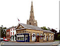
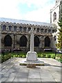
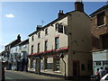
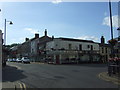
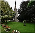
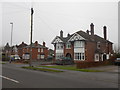
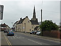
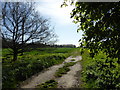
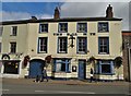
Photos of PE12 7HB


Area Information
Living in PE12 7HB offers a specific experience defined by its density and composition. This postcode covers a small residential cluster with a population of 1,816. The area sits at a population density of 1,426 people per square kilometre, indicating a closely knit neighbourhood rather than a sprawling suburb. Residents navigate a defined space where homes are situated relatively near one another. Daily life here is characterised by a established community feel within a compact footprint. The area is located in England, functioning as a distinct residential unit within the wider Humberston and Whittick locality. Prospective buyers looking at this postcode find a environment that balances residential comfort with proximity to services. The limited land area means that noise and activity from neighbours can be more immediate than in less dense locations. However, this density also fosters a sense of familiarity among inhabitants. It is an area where locals know each other, supported by the fact that the majority of homes are owner-occupied. The population mix skews towards adults, meaning the primary demographic navigating the streets consists of working adults. Shopping trips, school runs, and social interactions happen within close quarters. The layout supports a lifestyle where many essentials are accessible without long travels.
- Area Type
- Postcode
- Area Size
- Not available
- Population
- 1816
- Population Density
- 1426 people/km²
The property market in PE12 7HB is overwhelmingly dominated by owner-occupiers. Eighty-six per cent of households own their homes free of mortgage or are in the process of buying. This statistic defines the character of the estate and the demand dynamics for any properties on the open market. Houses constitute the primary accommodation type within this cluster. Buyers are usually purchasing a second property to their current home or a replacement for an existing stock of houses. For individuals looking at rental options, the supply is likely limited compared to the purchase market. The focus here is on exchanging an old property for a new one rather than investing in a buy-to-let portfolio. The high ownership rate implies that sellers are often upgrading or consolidating their housing situation. Competition for available homes may be steady given the captive market of local movers. The density of the area, with 1,426 people per square kilometre, means that land is a finite resource. New developments are unlikely to expand the housing stock significantly in the immediate future. Buyers must act quickly to secure a suitable house within the postcode. The market reflects a community that values stability and has made significant investments in their real estate.
House Prices in PE12 7HB
No properties found in this postcode.
Energy Efficiency in PE12 7HB
Residents of PE12 7HB benefit from a practical range of amenities within easy reach. There are five retail outlets available nearby. Notable among these are Tesco Spalding, Lincolnshire Co-operative Co, and another Lincolnshire Co-operative Co branch. These supermarkets provide essential groceries and household goods without the need for extensive travel. The concentration of retailers supports daily errands and weekly shopping trips. With a density of 1,426 people per square kilometre, the environment is conducive to walking or short drive trips to shops. The presence of Tesco Spalding offers a one-stop shop for many residents. The Lincolnshire Co-operative outlets provide specific products and community-focused shopping experiences. While the data does not list specific parks, leisure centres, or dining venues, the retail infrastructure ensures daily necessities are nearby. The lifestyle here is geared towards convenience and familiarity. You can manage your shopping duties efficiently using the existing supermarkets. The backdrop of living in this area is a functional, self-sufficient lifestyle supported by reliable local commerce.
Amenities
Schools
Families living in PE12 7HB have access to The Holbeach William Stukeley Church of England Voluntary Aided Primary School. This institution is rated good by Ofsted. The school serves the primary education needs of the local children before they transfer to secondary establishments outside the immediate postcodes. The presence of a voluntary aided primary school indicates support from the Church of England, as well as local authority funding. For children in the area, this primary option provides a nurturing environment close to home. The good rating confirms that the school meets high standards of education and behaviour management. There are no other primary schools listed within the immediate vicinity of PE12 7HB. Secondary education options are not detailed in the current data for this specific postcode. Families will need to look beyond the immediate boundaries for comprehensive secondary schooling. The proximity of The Holbeach William Stukeley provides a convenient start to the educational journey. Parents value the reduction of travel time associated with having a local primary school. The school's rating offers reassurance regarding the quality of education your child will receive.
| Rank | School | Type | Entry gender | Ages |
|---|
Explore more schools in this area
Go to Schools tabDemographics
The community in PE12 7HB is defined by a mature age profile. The median age is 47 years, and the most common age range for residents is adults between 30 and 64 years old. This age structure suggests that the area attracts families nearing the end of their child-rearing years or retired couples moving to a quieter setting. Home ownership stands at an impressive 86%, which is significantly higher than the national average. This high rate indicates financial stability among the local population and a strong preference for ownership over renting. Houses form the predominant accommodation type throughout the postcode. The architecture and layout likely reflect traditional designs suited to a family-oriented demographic. The ethnic makeup of the area predominantly consists of white residents, contributing to an established, homogenous community feel. With such a high percentage of homeowners, the social fabric is often centred around long-term relationships with the property and the neighbourhood. There is little transient population to disrupt the local rhythm. The stability of the demographic environment appeals to those seeking a quiet, predictable lifestyle. The age range ensures that there are both active adults and potentially older residents living in close proximity.
Household Size
Accommodation Type
Tenure
Ethnic Group
Religion
Household Composition
Age
Household Deprivation
NS-SEC
Explore more demographic insights in this area
Go to Demographics tabPlanning
Planning Constraints
- Flood RiskPremium
- Ramsar Wetland SitesPremium
- Area of Outstanding Natural BeautyPremium
- Protected Nature ReservePremium
- Protected WoodlandPremium