Area Overview for Padfield
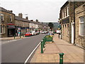
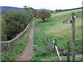
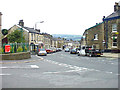
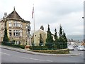
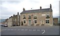
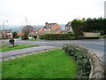
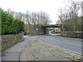
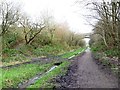
Photos of Padfield


Area Information
Living in Padfield offers a quiet, established character within a compact built-up area spanning 21.1 hectares. The median age of residents is 70, reflecting a community shaped by long-term settlement and stability. This is not a rapidly expanding suburb but a place where homes and neighbourhoods have remained largely unchanged for decades. The area’s small size means amenities and services are closely clustered, making daily life convenient without the sprawl of larger towns. Padfield’s proximity to rail stations like Hadfield, Dinting, and Glossop connects residents to nearby towns, while local shops and services within walking distance add to its self-contained charm. For those seeking a low-maintenance lifestyle with a strong sense of continuity, Padfield provides a distinct alternative to busier urban centres. Its demographic profile suggests a population that values familiarity and permanence, with 78% of homes owned by residents rather than rented. This mix of factors creates a place where routine and community are prioritised over novelty.
- Area Type
- Built Up Area 250
- Area Size
- 21.1 hectares
- Population
- Not available
- Population Density
- Not available
Residents of Padfield have access to a range of nearby amenities that support daily life. The rail network, with stations such as Hadfield and Glossop, provides easy access to shopping, leisure, and employment opportunities in surrounding areas. For retail, Tesco Hadfield and Tesco Glossop offer essential services, while Aldi Glossop adds variety to local shopping. Though the data does not list parks or leisure facilities directly, the proximity to rail and retail suggests a lifestyle focused on practicality and convenience. The area’s compact size means amenities are within walking or short driving distance, reducing the need for long commutes. This setup is ideal for those prioritising ease of access over sprawling urban or rural environments.
Amenities
Schools
The nearest school to Padfield is Padfield Community Primary School, which serves the area’s younger residents. Rated ‘good’ by Ofsted, it provides a solid foundation for primary education. While no secondary schools are listed in the data, the presence of a primary school suggests families with young children may find the area suitable for early education. The school’s rating indicates a commitment to quality teaching, though parents seeking secondary education options may need to look beyond Padfield. The absence of other schools in the data means the area’s educational landscape is focused on primary-level needs, which could be a consideration for families planning long-term residency.
| Rank | School | Type | Entry gender | Ages |
|---|
Explore more schools in this area
Go to Schools tabDemographics
Padfield’s population is predominantly older, with a median age of 70, indicating a community where retirement and long-term residency are common. The home ownership rate stands at 78%, suggesting a stable, settled population with fewer transient residents. While the data does not specify household composition or ethnic diversity, the overall figures imply a relatively homogenous demographic. The accommodation types are not detailed, but the high home ownership rate points to a mix of established properties, likely including family homes and smaller dwellings. The area’s age profile means local services and amenities cater to mature residents, with a focus on accessibility and convenience. This demographic structure contributes to a quiet, low-traffic environment where community ties are likely strong. However, the lack of detailed diversity data means Padfield’s social fabric remains largely unexplored in public records.
Household Size
Accommodation Type
Tenure
Ethnic Group
Religion
Household Composition
Age
Household Deprivation
NS-SEC
Explore more demographic insights in this area
Go to Demographics tabPlanning
Planning Constraints
- Crime RiskPremium