Area Overview for Norwell
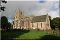
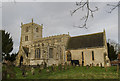
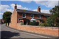
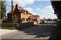
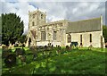
Photos of Norwell


Area Information
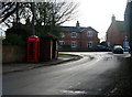
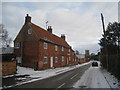
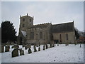
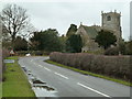
Norwell is a compact built-up area in England, spanning 27.8 hectares. Its population, though not explicitly stated, is likely small given the area’s size, with a median age of 70 suggesting a community skewed towards older residents. This demographic may shape the area’s rhythm, with a focus on stability and long-term residency. Norwell’s proximity to amenities like rail stations and retail outlets, including Waitrose Little and Lincolnshire Co-operative Co, ensures practical convenience for daily life. The presence of Norwell CofE Primary School, rated good by Ofsted, adds to the area’s appeal for families. While the data does not specify the number of residents, the high home ownership rate of 84% indicates a strong sense of local attachment. Living in Norwell offers a quiet, established environment with access to essential services, making it suitable for those prioritising security and proximity to infrastructure.
- Area Type
- Built Up Area 250
- Area Size
- 27.8 hectares
- Population
- Not available
- Population Density
- Not available
Norwell’s lifestyle is shaped by its proximity to retail and rail amenities. Five retail outlets, including Lincolnshire Co-operative Co and Waitrose Little, offer everyday shopping needs within reach. The rail stations provide access to broader networks, facilitating travel to nearby towns for leisure or work. While the data does not mention parks or leisure facilities, the combination of retail and transport infrastructure suggests a practical, service-oriented daily life. The area’s compact size ensures amenities are not distant, though those seeking extensive green spaces or cultural venues may need to look beyond Norwell. For residents valuing convenience over sprawling landscapes, this setup supports a low-effort, community-focused existence.
Amenities
Schools
Norwell CofE Primary School is the sole school listed in the data, serving the area’s primary education needs. Rated good by Ofsted, it provides a reliable foundation for young learners. The absence of secondary schools or additional educational institutions in the data means families may need to consider nearby towns for further schooling. The single school’s presence suggests a community where local education is prioritised, though the lack of diversity in school types may limit options for specialist or alternative education. For families relying on Norwell’s schools, the primary institution’s quality is a key asset, but secondary education planning should factor in commuting to adjacent areas.
| Rank | School | Type | Entry gender | Ages |
|---|
Explore more schools in this area
Go to Schools tabDemographics
Norwell’s population has a median age of 70, placing it among the oldest communities in England. This suggests a demographic where retirement is the predominant life stage, with a total population composition that likely includes a high proportion of elderly residents. Home ownership is prevalent, with 84% of households owning their properties, indicating a stable, long-term resident base. The data does not specify household types or accommodation diversity, but the 84% ownership figure implies a low rental market. The area’s demographics may influence local services, with amenities tailored to older adults. While no specific diversity statistics are provided, the absence of detailed breakdowns means the community’s cultural or ethnic composition remains unquantified. For quality of life, the high home ownership and low crime risk may contribute to a secure, low-maintenance lifestyle.
Household Size
Accommodation Type
Tenure
Ethnic Group
Religion
Household Composition
Age
Household Deprivation
NS-SEC
Explore more demographic insights in this area
Go to Demographics tabPlanning
Planning Constraints
- Crime RiskPremium