Area Overview for NN8 4JF
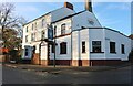
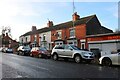
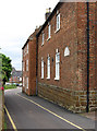
Photos of NN8 4JF


Area Information
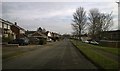
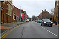
NN8 4JF is a small residential cluster in England covering just 1332 m². This compact footprint supports a population of 1590 residents, creating a tightly knit neighbourhood where everyone is likely to know their neighbours. Living in NN8 4JF means experiencing a concentrated community within a specific postcode area rather than a broad district. The area functions as a distinct residential pocket where daily life revolves around close proximity to essential services. You are part of a defined group of people sharing a limited geographical space that concentrates the needs and routines of the entire local community. The density here is defined by the sheer number of people packed into this small zone, making it a very specific type of urban environment. Your daily commute or walk to local shops feels immediate because the physical distance to services is minimal within these boundaries. This specific postcode area offers a clear sense of place for anyone interested in a contained residential setting in England.
- Area Type
- Postcode
- Area Size
- 1332 m²
- Population
- 1590
- Population Density
- 3386 people/km²
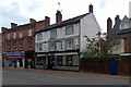
The property market in NN8 4JF is defined by a significant majority of owner-occupied homes. With 62% of residents being home owners, the area functions less like a rental hub and more like an established residential settlement where people stay long-term. The predominant accommodation type is Houses, suggesting a stock of detached, semi-detached, or terraced family homes rather than flats or apartments. Buying homes in NN8 4JF means joining a community where tenure is primarily private ownership. This structure implies that the local real estate market values permanent residents who contribute to the stability of the neighbourhood. The small area size of 1332 m² concentrates this housing stock, meaning there are fewer varied property types available compared to larger districts. You should expect a property search focused on houses suited to families or couples, given the age demographic and ownership rates. The market here reflects a standard residential area where ownership is the norm rather than the exception for the local population.
House Prices in NN8 4JF
No properties found in this postcode.
Energy Efficiency in NN8 4JF
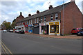
The lifestyle in NN8 4JF centres on immediate access to local retail and rail transport. Residents have five major retail options just minutes away, providing convenience for daily shopping needs. Morrisons Wellingborough, Iceland Wellingborough, and Aldi Wellingborough are among the specific stores available, offering groceries and household essentials without the need for long journeys. There is also one railway station connected to the area, Wellingborough Railway Station, which facilitates travel beyond the immediate neighbourhood. This combination of local supermarkets and rail access creates a practical daily routine where you can manage household budgets and commute efficiently. The retail score of 5 indicates a solid range of commercial services within practical reach. You do not need to drive far for basic necessities or to catch a train. The amenities bring a sense of self-sufficiency to the residents who call NN8 4JF home.
Amenities
Schools
Families living near NN8 4JF have access to several educational institutions within the local area. Croyland Junior School and Croyland Infant School operate as primary schools providing early education for local children. St Barnabas Church of England School also serves as a primary option for families seeking faith-based education in the vicinity. Brookfield School and Fairlawn School function as special schools, offering tailored education for students with specific needs. This mix of primary education and special education facilities provides a comprehensive network for children growing up in the NN8 4JF postcode. The presence of multiple primary options gives parents choices between different educational philosophies and management structures. Special schools located nearby ensure that the community supports diverse educational requirements for all children. Schools near NN8 4JF provide the necessary infrastructure for raising children within this small residential cluster without needing to travel far for education.
| Rank | School | Type | Entry gender | Ages |
|---|
Explore more schools in this area
Go to Schools tabDemographics
The community in NN8 4JF has a median age of 47 years. Most residents fall into the adults 30-64 years age range, indicating a largely established population. This demographic profile suggests the area attracts families and professionals who have settled down rather than students or young single occupants. Home ownership stands at 62% of the total population, meaning the majority of people living here own their properties outright or with a mortgage. The predominant ethnic group is White, reflecting the heritage and background of the main population block. Accommodation types are primarily Houses, which aligns with the home ownership statistics showing fewer rental properties than detached or semi-detached dwellings. The population density reaches 1193801 people per km², a figure that highlights the extremely concentrated nature of this postcode despite its tiny area size. You are living in an area where the housing stock matches the needs of adult home owners who value stability and established neighbourhoods.
Household Size
Accommodation Type
Tenure
Ethnic Group
Religion
Household Composition
Age
Household Deprivation
NS-SEC
Explore more demographic insights in this area
Go to Demographics tabPlanning
Planning Constraints
- Flood RiskPremium
- Ramsar Wetland SitesPremium
- Area of Outstanding Natural BeautyPremium
- Protected Nature ReservePremium
- Protected WoodlandPremium