Area Overview for NN3 7EY
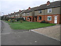
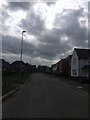
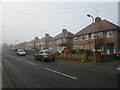
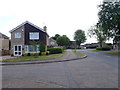
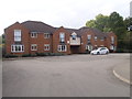
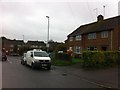
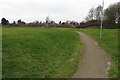
Photos of NN3 7EY


Area Information
Living in NN3 7EY offers a compact, residential experience in a small cluster of homes. The area covers 6,125 square metres and is home to 1,170 residents, making it one of the most densely populated postcode areas in England. Despite its size, it maintains a tight-knit community feel, with 89% of properties owner-occupied. The median age of 47 suggests a mature demographic, with adults aged 30–64 forming the largest age group. Daily life here is shaped by proximity to essential services, including retail outlets like Co-op Moulton and Tesco Spinny, and transport links such as Northampton Railway Station. The area’s safety profile is strong, with low flood risk, no protected natural sites, and a crime score of 88, indicating a secure environment. While the population density is high, the small scale of the area means residents are likely to know their neighbours, creating a sense of familiarity. For those seeking a quiet, established neighbourhood with practical amenities, NN3 7EY provides a blend of convenience and stability.
- Area Type
- Postcode
- Area Size
- 6125 m²
- Population
- 1170
- Population Density
- 4322 people/km²
The property market in NN3 7EY is characterised by high home ownership (89%) and a predominance of houses. This suggests a market skewed towards owner-occupied properties rather than rental units, which may limit availability for buyers seeking to move into the area. The compact size of the postcode—just 6,125 square metres—means the housing stock is limited, and the immediate surroundings likely offer few additional properties. For buyers, this could translate to a competitive market where properties are in demand. The focus on houses rather than flats or apartments may appeal to those prioritising space and privacy. However, the small area size also means that property prices could be influenced by proximity to amenities like Northampton Railway Station and nearby retail hubs. Buyers should consider the area’s density when evaluating long-term suitability, as the market is unlikely to expand significantly.
House Prices in NN3 7EY
Showing 12 properties
| Address | Type | Beds | Baths | Last Sale Price | Last Sale Date | |
|---|---|---|---|---|---|---|
| 3 Wagtail Close, Northampton, NN3 7EY | Detached | 4 | 1 | £360,000 | Jun 2025 | |
| 2 Wagtail Close, Northampton, NN3 7EY | Detached | 4 | 2 | £321,995 | Sep 2019 | |
| 4 Wagtail Close, Northampton, NN3 7EY | house | - | - | £182,500 | Sep 2009 | |
| 5 Wagtail Close, Northampton, NN3 7EY | house | - | - | £190,000 | Jul 2009 | |
| 8 Wagtail Close, Northampton, NN3 7EY | house | - | - | £237,500 | Mar 2009 | |
| 6 Wagtail Close, Northampton, NN3 7EY | Detached | - | - | £217,000 | Mar 2009 | |
| 7 Wagtail Close, Northampton, NN3 7EY | Detached | - | - | - | - | |
| 9 Wagtail Close, Northampton, NN3 7EY | Detached | - | - | - | - | |
| 11 Wagtail Close, Northampton, NN3 7EY | Detached | - | - | - | - | |
| 1 Wagtail Close, Northampton, NN3 7EY | Detached | - | - | - | - |
Energy Efficiency in NN3 7EY
The lifestyle in NN3 7EY is shaped by its proximity to essential amenities. Retail options include Co-op Moulton, Tesco Spinny, and Aldi Overstone, offering a range of shopping choices within walking distance. These stores cater to daily needs, from groceries to household goods, reducing the necessity for long journeys. Transport links are robust, with the University Bus Interchange and Northampton Bus Interchange providing access to broader regional networks. Northampton Railway Station further enhances connectivity, allowing residents to travel to nearby cities with ease. While the area lacks extensive leisure or recreational facilities, the nearby retail and transport hubs contribute to a convenient, practical lifestyle. The compact nature of the area means amenities are closely grouped, fostering a sense of accessibility. For those prioritising convenience over expansive leisure options, NN3 7EY offers a functional, well-served environment.
Amenities
Schools
The nearest schools to NN3 7EY are both Kings Meadow School, which is designated as a special school. While the data does not provide Ofsted ratings or specific educational outcomes, the presence of two special schools in close proximity suggests the area is well-served for families requiring specialist education. This could be particularly beneficial for parents of children with additional needs, offering dedicated resources and support. However, the absence of mainstream schools or a broader range of educational institutions may be a consideration for families seeking a mix of school types. The concentration of special schools indicates a focus on tailored education, but those prioritising a variety of school options may need to look further afield. For residents relying on local schools, the availability of two special schools provides a reliable resource within the community.
| Rank | School | Type | Entry gender | Ages |
|---|
Explore more schools in this area
Go to Schools tabDemographics
The community in NN3 7EY is predominantly composed of adults aged 30–64, with a median age of 47. This suggests a mature, settled population, many of whom are likely to be long-term residents. Home ownership is exceptionally high at 89%, indicating a stable housing market where most properties are owner-occupied rather than rented. The accommodation type is primarily houses, which aligns with the area’s small, residential character. The predominant ethnic group is White, though no specific diversity data is provided. The high population density—191,034 people per square kilometre—reflects the area’s compact nature, with limited space for expansion. This density may influence the pace of life, creating a more intimate setting where social interactions are frequent. However, it also means resources and services must be efficiently distributed to meet demand. The demographic profile suggests a community focused on stability, with fewer young families compared to other areas.
Household Size
Accommodation Type
Tenure
Ethnic Group
Religion
Household Composition
Age
Household Deprivation
NS-SEC
Explore more demographic insights in this area
Go to Demographics tabPlanning
Planning Constraints
- Flood RiskPremium
- Ramsar Wetland SitesPremium
- Area of Outstanding Natural BeautyPremium
- Protected Nature ReservePremium
- Protected WoodlandPremium