Area Overview for NN3 7DA
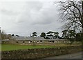
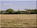
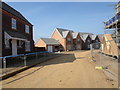
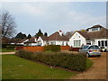
Photos of NN3 7DA


Area Information
Living in NN3 7DA means being part of a compact, residential cluster in England, home to 2505 people across 1.1 hectares. The area’s density—292 people per square kilometre—suggests a tight-knit community, though its small size means it is not a sprawling suburb. Most residents are adults aged 30-64, with a median age of 47, indicating a stable, mature population. The area is predominantly owner-occupied, with 87% of homes in private hands, and housing is largely composed of detached or semi-detached houses. This creates a quiet, residential character, though the proximity to amenities like Overstone Primary School and nearby retail hubs adds convenience. While the area lacks major infrastructure, its small footprint means residents are within practical reach of Northampton’s transport networks and services. Daily life here balances local simplicity with access to essential services, making it appealing for those seeking a settled, low-maintenance lifestyle.
- Area Type
- Postcode
- Area Size
- 1.1 hectares
- Population
- 2505
- Population Density
- 292 people/km²
The property market in NN3 7DA is characterised by high home ownership (87%) and a predominance of houses. This suggests a market skewed towards owner-occupiers rather than renters, with limited availability of flats or apartments. The small area size—just 1.1 hectares—means the housing stock is constrained, potentially leading to competition for properties. Given the focus on houses, buyers should expect larger, more traditional homes, which may appeal to families or those seeking space. However, the area’s compact nature means the immediate surroundings are critical for access to amenities. While the property market may not be expansive, its proximity to Northampton’s transport hubs and schools could enhance its appeal. Buyers should consider the balance between property size and the need for nearby services, as the area’s limited footprint means expansion is unlikely.
House Prices in NN3 7DA
Showing 28 properties
| Address | Type | Beds | Baths | Last Sale Price | Last Sale Date | |
|---|---|---|---|---|---|---|
| 14 The Furrows, Moulton, NN3 7DA | Semi-detached | 3 | 2 | £290,000 | Apr 2024 | |
| 30 The Furrows, Moulton, NN3 7DA | Terraced | 3 | 2 | £99,000 | Dec 2023 | |
| 10 The Furrows, Moulton, NN3 7DA | house | - | - | £295,000 | Aug 2021 | |
| 7 The Furrows, Moulton, NN3 7DA | Semi-detached | 3 | - | £290,000 | Mar 2021 | |
| 11 The Furrows, Moulton, NN3 7DA | house | - | - | £238,500 | Feb 2021 | |
| 8 The Furrows, Moulton, NN3 7DA | house | - | - | £290,000 | Feb 2021 | |
| 3 The Furrows, Moulton, NN3 7DA | house | - | - | £280,000 | Jan 2021 | |
| 2 The Furrows, Moulton, NN3 7DA | Terraced | 3 | 2 | £282,500 | Nov 2020 | |
| 20 The Furrows, Moulton, NN3 7DA | Terraced | 2 | - | £114,000 | Aug 2019 | |
| 9 The Furrows, Moulton, NN3 7DA | Semi-detached | 3 | 1 | £240,000 | Aug 2019 |
Energy Efficiency in NN3 7DA
The lifestyle in NN3 7DA is shaped by its proximity to essential amenities. Retail options include Aldi Overstone, Co-op Moulton, and Tesco Spinny, providing everyday shopping convenience. These stores cater to practical needs, though the area lacks larger supermarkets or specialty shops. For transport, the University Bus Interchange and Northampton Bus Interchange offer regular services, while Northampton Railway Station connects to regional destinations. The area’s compact nature means these amenities are within walking or short driving distance, supporting a low-effort lifestyle. While there is no mention of parks or leisure facilities in the data, the presence of schools and retail suggests a focus on family and daily living over recreational spaces. This balance of accessibility and simplicity defines the area’s character.
Amenities
Schools
Residents of NN3 7DA have access to two schools within practical reach. Overstone Primary School, a primary institution with a ‘good’ Ofsted rating, provides a reliable foundation for younger children. Nearby is Overstone Park School, a special needs school rated ‘inadequate’ by Ofsted. This mix of school types offers options for families with children requiring tailored education, though the inadequate rating at Overstone Park School may raise concerns about resources or outcomes. The presence of a special school suggests the area caters to specific educational needs, but prospective buyers should investigate further into the quality of support and facilities. For families prioritising mainstream education, the primary school’s positive rating is a clear advantage, though the limited range of school types may restrict choices for others.
| Rank | School | Type | Entry gender | Ages |
|---|
Explore more schools in this area
Go to Schools tabDemographics
The community in NN3 7DA is defined by its demographic consistency. With a median age of 47, the population skews towards adults aged 30-64, reflecting a mature, established resident base. Home ownership is exceptionally high at 87%, suggesting a long-term commitment to the area. Most properties are houses, which aligns with the demographic preference for family-friendly or semi-rural living. The predominant ethnic group is White, though no specific data on diversity or deprivation is provided. The age profile and ownership rates indicate a community that prioritises stability over transient living. With no evidence of significant youth or elderly populations, the area likely sees limited demand for student housing or retirement communities. This demographic profile suggests a focus on quality of life through private ownership and a lack of rental market pressure, though it may limit opportunities for younger buyers seeking more dynamic environments.
Household Size
Accommodation Type
Tenure
Ethnic Group
Religion
Household Composition
Age
Household Deprivation
NS-SEC
Explore more demographic insights in this area
Go to Demographics tabPlanning
Planning Constraints
- Flood RiskPremium
- Ramsar Wetland SitesPremium
- Area of Outstanding Natural BeautyPremium
- Protected Nature ReservePremium
- Protected WoodlandPremium