Area Overview for NN3 6PL
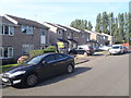
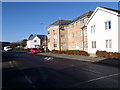
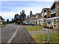
Photos of NN3 6PL


Area Information
Living in NN3 6PL offers a compact, residential experience in a small cluster of homes spread across 4,678 square metres. With a population of 1,625 people, the area is densely populated, at 347,400 residents per square kilometre, creating a close-knit community feel. This postcode is ideal for those seeking a balance between urban convenience and a quieter, residential setting. The area’s proximity to Northampton Railway Station and multiple bus interchanges ensures easy access to nearby towns and cities. Daily life here is shaped by its small-scale nature, with amenities within practical reach. While the community is predominantly composed of adults aged 30–64, the median age of 47 suggests a mature demographic. The area’s focus on houses rather than flats reflects a preference for family-friendly living. For buyers, NN3 6PL’s limited size means properties are likely to be in high demand, with a strong emphasis on proximity to essential services and transport links.
- Area Type
- Postcode
- Area Size
- 4678 m²
- Population
- 1625
- Population Density
- 4158 people/km²
The property market in NN3 6PL is characterised by a 58% home ownership rate, indicating a blend of owner-occupied homes and rental properties. The accommodation type is exclusively houses, which suggests a focus on family-friendly, standalone homes rather than apartments or flats. Given the area’s small size—just 4,678 square metres—properties are likely to be in high demand, with limited scope for expansion. Buyers should consider the proximity to amenities and transport links, as the area’s compact nature means immediate surroundings are critical. The predominance of houses may appeal to those seeking space and privacy, though the high population density could mean limited availability. For investors, the market’s stability and demand from long-term residents may present opportunities, though competition for properties is likely to be fierce.
House Prices in NN3 6PL
Showing 19 properties
| Address | Type | Beds | Baths | Last Sale Price | Last Sale Date | |
|---|---|---|---|---|---|---|
| 4 Dalston Walk, Northampton, NN3 6PL | Terraced | 3 | 1 | £215,000 | Jul 2024 | |
| 1 Dalston Walk, Northampton, NN3 6PL | house | - | - | £225,000 | Apr 2024 | |
| 5 Dalston Walk, Northampton, NN3 6PL | Terraced | 3 | 1 | £210,000 | Feb 2023 | |
| 14 Dalston Walk, Northampton, NN3 6PL | Terraced | 3 | - | £195,000 | Dec 2018 | |
| 3 Dalston Walk, Northampton, NN3 6PL | Terraced | 3 | - | £142,500 | Dec 2015 | |
| 18 Dalston Walk, Northampton, NN3 6PL | Terraced | 3 | 1 | £125,000 | Apr 2015 | |
| 8 Dalston Walk, Northampton, NN3 6PL | Terraced | 3 | 1 | £119,950 | Jul 2006 | |
| 2 Dalston Walk, Northampton, NN3 6PL | Terraced | - | - | £65,995 | Jun 2001 | |
| 10 Dalston Walk, Northampton, NN3 6PL | Terraced | - | - | £43,995 | Mar 1998 | |
| 9 Dalston Walk, Northampton, NN3 6PL | Bungalow | - | - | - | - |
Energy Efficiency in NN3 6PL
Residents of NN3 6PL have access to a range of amenities within practical reach, enhancing daily life. The retail sector includes five shops, such as Tesco Spinny, Co-op Bushland, and Morrisons Kingsley, providing convenience for grocery shopping and other essentials. Public transport is well-served by two bus interchanges—the University Bus Interchange and Northampton Bus Interchange—as well as Northampton Railway Station, which connects to broader regional networks. While the area lacks dedicated parks or leisure facilities in the data, the proximity to transport hubs and retail options suggests a lifestyle focused on accessibility and efficiency. The presence of multiple retail outlets and transport links ensures that residents can meet their needs without long commutes, fostering a practical, community-oriented way of life.
Amenities
Schools
The nearest school to NN3 6PL is Boothville Primary School, which holds a good Ofsted rating. This primary school is a key asset for families with young children, offering a reliable foundation for early education. The absence of secondary schools in the data suggests that parents may need to look further afield for secondary education, though the proximity to Northampton Railway Station and bus interchanges could ease commutes. The presence of a single primary school with a good rating indicates a focus on early education within the area, which is crucial for families prioritising school quality. However, the lack of secondary options may require careful planning for older children. Overall, the school infrastructure supports families with younger children but necessitates additional consideration for long-term educational needs.
| Rank | School | Type | Entry gender | Ages |
|---|
Explore more schools in this area
Go to Schools tabDemographics
The community in NN3 6PL is predominantly composed of adults aged 30–64, with a median age of 47. This suggests a stable, mature population, likely with established careers and family ties. Home ownership stands at 58%, indicating a mix of owner-occupied properties and rentals. The accommodation type is primarily houses, reflecting a preference for single-family homes over flats. The predominant ethnic group is White, though no specific data on diversity or deprivation is provided. The high population density—347,400 people per square kilometre—means the area is intensely populated, which can influence the pace of life and availability of private space. For buyers, this demographic profile implies a community focused on long-term residency and family-oriented living, with a strong emphasis on property as a long-term investment.
Household Size
Accommodation Type
Tenure
Ethnic Group
Religion
Household Composition
Age
Household Deprivation
NS-SEC
Explore more demographic insights in this area
Go to Demographics tabPlanning
Planning Constraints
- Flood RiskPremium
- Ramsar Wetland SitesPremium
- Area of Outstanding Natural BeautyPremium
- Protected Nature ReservePremium
- Protected WoodlandPremium