Area Overview for NN29 7LA
Photos of NN29 7LA


Area Information
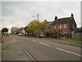
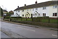
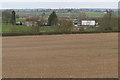
NN29 7LA is a small, tightly knit residential area in England, covering just 11 hectares with a population of 2166 people. The density of 122 people per square kilometre suggests a compact, community-oriented layout. This postcode area is characterised by its modest size and the presence of family homes, reflecting a demographic skewed towards adults aged 30–64. The area’s appeal lies in its quiet, low-density living, with no major environmental constraints or planning restrictions. Residents benefit from a stable housing market, with 77% of properties owner-occupied, and a strong sense of local identity. While it lacks large-scale amenities, its proximity to Wellingborough Railway Station and nearby retail outlets like Co-op Wollaston and Aldi ensures practical connectivity. The area’s safety profile is notable, with a crime risk score of 83, indicating below-average crime rates. For those seeking a peaceful, family-friendly environment with minimal urban pressures, NN29 7LA offers a straightforward, unpretentious lifestyle.
- Area Type
- Postcode
- Area Size
- 11.0 hectares
- Population
- 2166
- Population Density
- 122 people/km²
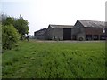
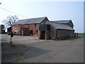
The property market in NN29 7LA is dominated by owner-occupied homes, with 77% of properties in private hands. This high rate of home ownership suggests a stable, long-term resident base with little turnover. The accommodation type is predominantly houses, which is unusual for a small postcode area but aligns with the low population density of 122 people per square kilometre. This indicates a focus on family homes rather than apartments or flats, which are typically found in higher-density urban areas. For buyers, this means the market is likely to be competitive for those seeking a single-family home, with limited rental options available. The small size of the area also means that property availability is constrained, and proximity to nearby amenities like Wellingborough Railway Station may be a key selling point for those prioritising transport links.
House Prices in NN29 7LA
Showing 64 properties
| Address | Type | Beds | Baths | Last Sale Price | Last Sale Date | |
|---|---|---|---|---|---|---|
| 75 Queen Street, Bozeat, NN29 7LA | Detached | 3 | 1 | £315,000 | Sep 2025 | |
| 32 Queen Street, Bozeat, NN29 7LA | Semi-detached | 3 | 2 | £250,000 | Nov 2024 | |
| 61 Queen Street, Bozeat, NN29 7LA | Bungalow | 2 | 1 | £280,000 | Nov 2024 | |
| 58 Queen Street, Bozeat, NN29 7LA | Bungalow | - | - | £230,000 | Jun 2024 | |
| 83 Queen Street, Bozeat, NN29 7LA | Bungalow | - | - | £320,000 | Sep 2023 | |
| 59 Queen Street, Bozeat, NN29 7LA | Bungalow | 2 | - | £290,000 | Mar 2023 | |
| 11 Queen Street, Bozeat, NN29 7LA | house | - | - | £270,000 | Oct 2022 | |
| 38 Queen Street, Bozeat, NN29 7LA | Bungalow | 3 | 1 | £128,000 | Mar 2022 | |
| 6 Queen Street, Bozeat, NN29 7LA | house | - | - | £200,000 | Jan 2022 | |
| 36 Queen Street, Bozeat, NN29 7LA | Semi-detached | 4 | 1 | £300,000 | Aug 2021 |
Energy Efficiency in NN29 7LA
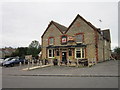
The lifestyle in NN29 7LA is shaped by its proximity to practical amenities like Co-op Wollaston, Co-op Harrold, and Aldi 1 Worcester Way, which provide essential shopping and food services. These retail outlets cater to daily needs, reducing the necessity for long trips to larger centres. The Wellingborough Railway Station offers access to regional transport, connecting residents to nearby towns and cities. While the area lacks large parks or leisure facilities, its small scale and low density contribute to a quieter, more private living environment. The absence of major entertainment venues or dining options means that residents may need to venture beyond the postcode for more varied experiences, but the existing amenities ensure a functional, self-contained lifestyle for those prioritising convenience over urban vibrancy.
Amenities
Schools
The nearest school to NN29 7LA is Bozeat Community Primary School, which serves the local primary education needs of the area. The school has an Ofsted rating of ‘good’, indicating a satisfactory standard of teaching and student outcomes. As a primary school, it caters to children aged 4–11, making it a critical resource for families with young children. The absence of secondary schools in the immediate vicinity means that students may need to travel to nearby towns for further education, but the ‘good’ rating suggests that the primary school provides a solid foundation. For parents prioritising quality education, the school’s performance is a positive factor, though the lack of higher-level schooling within the area may influence long-term housing decisions.
| Rank | School | Type | Entry gender | Ages |
|---|
Explore more schools in this area
Go to Schools tabDemographics
The population of NN29 7LA is predominantly adults aged 30–64, with a median age of 47. This suggests a mature, established community with a focus on stability rather than transient populations. Home ownership is high at 77%, indicating a strong preference for long-term residency over renting. The accommodation type is largely houses, which aligns with the area’s low density and suburban character. The predominant ethnic group is White, reflecting a homogenous demographic profile. The absence of specific data on deprivation or diversity means the area’s social fabric is not extensively detailed, but the high home ownership and age profile suggest a community prioritising security and family life. With no significant youth or elderly populations noted, the area likely caters to middle-aged households seeking a quiet, low-maintenance environment.
Household Size
Accommodation Type
Tenure
Ethnic Group
Religion
Household Composition
Age
Household Deprivation
NS-SEC
Explore more demographic insights in this area
Go to Demographics tabPlanning
Planning Constraints
- Flood RiskPremium
- Ramsar Wetland SitesPremium
- Area of Outstanding Natural BeautyPremium
- Protected Nature ReservePremium
- Protected WoodlandPremium