Area Overview for NN2 7PH
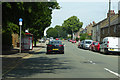
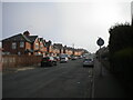
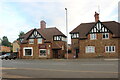
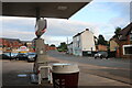
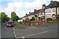
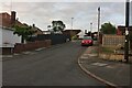
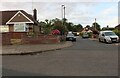
Photos of NN2 7PH

Area Information
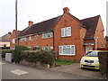
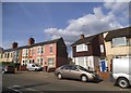
NN2 7PH is a small, tightly knit residential cluster in England, home to 1,837 people. Its compact size means it offers a quiet, community-focused lifestyle, distinct from larger urban areas. The area is characterised by a balance of practicality and accessibility, with nearby transport links and retail options within easy reach. Residents here are predominantly adults aged 30–64, reflecting a mature, stable population. Daily life is shaped by proximity to Northampton’s infrastructure, including the Northampton Railway Station and University Bus Interchange, which connect the area to broader networks. While the postcode itself is small, it sits within a region with a strong sense of local identity, supported by nearby amenities such as Waitrose Kingsthorpe and Cook Kingsthorpe. The absence of protected natural sites or flood risks adds to its appeal as a low-maintenance, safe place to live. For those seeking a blend of convenience and tranquillity, NN2 7PH offers a straightforward, no-frills lifestyle with clear advantages for families and professionals alike.
- Area Type
- Postcode
- Area Size
- Not available
- Population
- 1837
- Population Density
- 10038 people/km²
The property market in NN2 7PH is defined by a 45% home ownership rate, with houses being the dominant accommodation type. This suggests a market where owner-occupied homes are the norm, though a notable portion of the housing stock is likely rented out. Given the small size of the area, the number of properties available for sale or rent is limited, which can create a competitive environment for buyers. The prevalence of houses over flats or apartments may appeal to those seeking more space or privacy, though it also means the area is less suited to investors looking for high-density rental opportunities. For prospective buyers, the compact nature of NN2 7PH means that properties are likely to be in close proximity to essential services and transport links, which could be a significant advantage. However, the limited scale of the area may also mean that buyers need to consider nearby suburbs for more options.
House Prices in NN2 7PH
No properties found in this postcode.
Energy Efficiency in NN2 7PH
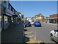
Living in NN2 7PH offers access to a range of practical amenities within easy reach. The area is served by five retail outlets, including notable stores such as Heron Kingsthorpe, Cook Kingsthorpe, and Waitrose Kingsthorpe, providing options for groceries, dining, and general shopping. For transport, residents can utilise the University Bus Interchange and Northampton Bus Interchange, which connect to broader networks, while the Northampton Railway Station offers direct links to other parts of the country. These amenities contribute to a lifestyle that balances convenience with a sense of local character. The presence of multiple retail and transport hubs ensures that daily needs are met without the need to travel far, making the area appealing for those who value accessibility without sacrificing a quiet, residential environment.
Amenities
Schools
| Rank | School | Type | Entry gender | Ages |
|---|
Explore more schools in this area
Go to Schools tabDemographics
The community in NN2 7PH is predominantly composed of adults aged 30–64, with a median age of 47. This suggests a population that is largely in their prime working years, with a strong presence of middle-aged households. Home ownership stands at 45%, indicating a mix of owner-occupied properties and rental units. The accommodation type is primarily houses, which is notable in a region where flats or apartments are often more common. The predominant ethnic group is White, reflecting a homogenous demographic profile. While this data does not indicate levels of deprivation, the relatively high proportion of owner-occupied homes and the absence of significant environmental constraints suggest a stable, low-risk environment. The age distribution and property types imply a community that prioritises long-term residency and family-oriented living, with fewer transient populations.
Household Size
Accommodation Type
Tenure
Ethnic Group
Religion
Household Composition
Age
Household Deprivation
NS-SEC
Explore more demographic insights in this area
Go to Demographics tabPlanning
Planning Constraints
- Flood RiskPremium
- Ramsar Wetland SitesPremium
- Area of Outstanding Natural BeautyPremium
- Protected Nature ReservePremium
- Protected WoodlandPremium