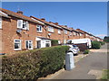
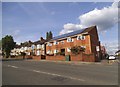
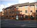
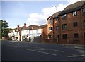
Area Overview for NN2 6LJ
Photos of NN2 6LJ


Area Information
Living in NN2 6LJ means being part of a tightly knit residential cluster in central England. The area covers just 3.5 hectares, housing 2,122 people in a high-density setting. This compact postcode is defined by its proximity to essential services and transport links, making it practical for daily life. The community here is predominantly composed of adults aged 30–64, reflecting a mature demographic with established routines. While the area is small, it is well-served by nearby schools, retail hubs, and public transport, creating a self-contained environment. Residents benefit from quick access to Northampton’s infrastructure, including the city’s main railway station and major bus routes. The postcode’s compact size means amenities are within walking or cycling distance for many, though its limited area also means housing options are constrained. For those seeking a balance between urban convenience and a quieter residential setting, NN2 6LJ offers a focused, accessible lifestyle.
- Area Type
- Postcode
- Area Size
- 3.5 hectares
- Population
- 2122
- Population Density
- 3817 people/km²
The property market in NN2 6LJ is characterised by a mix of owner-occupied and rental properties, with 49% of homes owned by residents. The area is predominantly composed of houses, which is unusual for a small postcode but suggests a focus on family homes. Given the high population density and limited area size, housing stock is constrained, and availability may be competitive. The compact nature of the postcode means properties are likely to be in close proximity to amenities and transport links, which can be a draw for buyers prioritising convenience. However, the small footprint also means limited scope for expansion or new developments. For buyers, this area offers a blend of residential stability and proximity to essential services, though the market’s size may limit options for those seeking larger or more varied properties.
House Prices in NN2 6LJ
Showing 21 properties
| Address | Type | Beds | Baths | Last Sale Price | Last Sale Date | |
|---|---|---|---|---|---|---|
| Unit 3A, Horsley Road, Northampton, NN2 6LJ | Industrial | - | - | - | - | |
| Unit 1 Adjacent To Ace Mini Skips, Whites Yard, Horsley Road, Northampton, NN2 6LJ | Office | - | - | - | - | |
| Unit 3, Whites Yard, Horsley Road, Northampton, NN2 6LJ | Industrial | - | - | - | - | |
| Station Taxis, Suite 4, Logistics House, Horsley Road, Northampton, NN2 6LJ | Office | - | - | - | - | |
| Suite 18, Logistics House, Horsley Road, Northampton, NN2 6LJ | Office | - | - | - | - | |
| Suite 2, Logistics House, Horsley Road, Northampton, NN2 6LJ | Office | - | - | - | - | |
| Suite 11, Logistics House, Horsley Road, Northampton, NN2 6LJ | Office | - | - | - | - | |
| Suite 3, Logistics House, Horsley Road, Northampton, NN2 6LJ | Office | - | - | - | - | |
| Suite 15, Logistics House, Horsley Road, Northampton, NN2 6LJ | general_industrial | - | - | - | - | |
| Suite 10, Logistics House, Horsley Road, Northampton, NN2 6LJ | Office | - | - | - | - |
Energy Efficiency in NN2 6LJ
The lifestyle in NN2 6LJ is shaped by its proximity to retail, transport, and community hubs. Nearby, Asda Northampton, Aldi Kingsthorpe, and Co-op Semilong provide essential shopping options, while the Northampton Bus Interchange and University Bus Interchange offer frequent services. The area’s compact nature means residents can access these amenities without lengthy commutes. Although parks or leisure facilities are not explicitly listed, the presence of transport links and retail hubs suggests a functional, urban lifestyle. The area’s focus on practicality over sprawling green spaces may appeal to those prioritising convenience over expansive recreational areas. For families, the availability of schools and shops within walking distance reinforces the area’s suitability for everyday living.
Amenities
Schools
Residents of NN2 6LJ have access to several educational institutions, including Northgate School Arts College and Northgate School Academy Trust, both of which are special schools. Cambian Northampton School, another special school in the area, holds a ‘good’ Ofsted rating, indicating a reliable standard of education. The presence of multiple special schools suggests the area caters to families with children requiring tailored educational support. While no mainstream schools are listed, the availability of special schools may be critical for families with specific needs. The concentration of these institutions within practical reach highlights the area’s focus on supporting diverse educational requirements, though parents should verify whether these schools meet their child’s needs before relocating.
| Rank | School | Type | Entry gender | Ages |
|---|
Explore more schools in this area
Go to Schools tabDemographics
The population of NN2 6LJ is 2,122 people, with a median age of 47. This suggests a community skewed toward middle-aged and older adults, with the most common age range being 30–64 years. Home ownership here is relatively low at 49%, indicating a significant portion of residents rent their homes. The area is primarily composed of houses rather than flats, which aligns with the demographic profile of established households. The predominant ethnic group is White, reflecting a homogenous population. This demographic structure implies a stable, long-term resident base with fewer transient populations. The high population density—61,371 people per square kilometre—means the area is intensely populated for its size, which can influence local dynamics such as community interaction and demand for services.
Household Size
Accommodation Type
Tenure
Ethnic Group
Religion
Household Composition
Age
Household Deprivation
NS-SEC
Explore more demographic insights in this area
Go to Demographics tabPlanning
Planning Constraints
- Flood RiskPremium
- Ramsar Wetland SitesPremium
- Area of Outstanding Natural BeautyPremium
- Protected Nature ReservePremium
- Protected WoodlandPremium