Area Overview for NN2 6DD
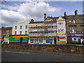
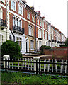
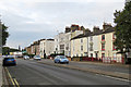
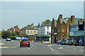
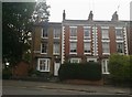
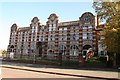
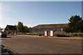
Photos of NN2 6DD


Area Information
NN2 6DD is a small, tightly packed residential cluster in England, covering just 5,198 square metres. With a population of 1,925 people, it is one of the most densely populated areas in the country, at 370,325 people per square kilometre. This compact postcode area is defined by its proximity to urban infrastructure, with a mix of retail, transport, and community amenities within easy reach. Daily life here is characterised by a balance between residential tranquillity and urban convenience. The area’s proximity to Northampton Bus Interchange and Northampton Railway Station ensures connectivity to wider networks, while nearby shops like Co-op Semilong and Asda Northampton cater to everyday needs. Despite its density, the area maintains a distinct identity, shaped by its small-scale housing stock and established local services. For those seeking a compact, well-serviced home with access to urban amenities, NN2 6DD offers a unique blend of proximity and practicality.
- Area Type
- Postcode
- Area Size
- 5198 m²
- Population
- 1925
- Population Density
- 10110 people/km²
The property market in NN2 6DD is shaped by its low home ownership rate of 30%, indicating that most properties are rented rather than owner-occupied. The area’s accommodation type is predominantly houses, which is unusual for such a densely populated postcode. This suggests a mix of larger, standalone homes or semi-detached properties, possibly catering to families or individuals seeking more space. Given the small area size and high density, the housing stock is likely limited, with limited scope for expansion. Buyers should consider the area’s compact nature and its proximity to urban amenities when evaluating properties. The market may appeal to those prioritising convenience over space, with homes typically located near transport links and retail hubs.
House Prices in NN2 6DD
Showing 48 properties
| Address | Type | Beds | Baths | Last Sale Price | Last Sale Date | |
|---|---|---|---|---|---|---|
| 11 Stanley Street, Northampton, NN2 6DD | Terraced | 2 | 1 | £180,000 | Aug 2025 | |
| 79 Stanley Street, Northampton, NN2 6DD | Terraced | 3 | 1 | £182,000 | Jun 2025 | |
| 39 Stanley Street, Northampton, NN2 6DD | Terraced | 2 | - | £187,000 | Mar 2025 | |
| 37 Stanley Street, Northampton, NN2 6DD | Terraced | 2 | 1 | £173,000 | May 2024 | |
| 83 Stanley Street, Northampton, NN2 6DD | Terraced | 2 | 1 | £160,000 | Feb 2024 | |
| 61 Stanley Street, Northampton, NN2 6DD | Terraced | 2 | 1 | £192,500 | Feb 2024 | |
| 43 Stanley Street, Northampton, NN2 6DD | Terraced | 3 | 1 | £175,000 | Jan 2024 | |
| 65 Stanley Street, Northampton, NN2 6DD | Terraced | 2 | 1 | £140,000 | Nov 2023 | |
| 71 Stanley Street, Northampton, NN2 6DD | Terraced | 3 | 1 | £175,000 | Mar 2023 | |
| 31 Stanley Street, Northampton, NN2 6DD | Terraced | 2 | 1 | £185,000 | Dec 2022 |
Energy Efficiency in NN2 6DD
The lifestyle in NN2 6DD is shaped by its proximity to essential amenities. Retail options include Co-op Semilong, Asda Northampton, and Aldi Kingsthorpe, providing a range of shopping and grocery needs within walking or short driving distance. The area’s transport links, such as Northampton Bus Interchange and Northampton Railway Station, facilitate access to broader urban and regional services. While the data does not mention parks or leisure facilities, the compact nature of the area suggests that residents may rely on nearby urban green spaces or community centres. The combination of retail, transport, and urban connectivity creates a practical, convenience-driven lifestyle, ideal for those prioritising accessibility over expansive leisure options.
Amenities
Schools
The nearest school to NN2 6DD is St Paul’s Lower School, a primary institution serving the local community. While no secondary schools are listed in the data, the presence of a primary school suggests that families with younger children may find the area suitable for early education. The absence of secondary schools nearby could mean that residents must travel to adjacent areas for further schooling. However, the proximity to Northampton’s transport network, including bus and rail services, may mitigate this challenge. The availability of a primary school adds to the area’s appeal for families, though parents should consider the need for additional transport arrangements for older children.
| Rank | School | Type | Entry gender | Ages |
|---|
Explore more schools in this area
Go to Schools tabDemographics
The community in NN2 6DD is predominantly composed of adults aged 30–64, with a median age of 47. This suggests a mature population, likely with established careers and families. Home ownership in the area is relatively low at 30%, indicating that a significant portion of residents rent their homes. The accommodation type is primarily houses, which is uncommon in densely populated areas, suggesting a mix of larger properties or detached homes. The predominant ethnic group is White, with no specific data on other demographics provided. The population density of 370,325 people per square kilometre is exceptionally high, comparable to major city centres. This density may influence the area’s character, with limited open space but a strong focus on communal living and shared amenities.
Household Size
Accommodation Type
Tenure
Ethnic Group
Religion
Household Composition
Age
Household Deprivation
NS-SEC
Explore more demographic insights in this area
Go to Demographics tabPlanning
Planning Constraints
- Flood RiskPremium
- Ramsar Wetland SitesPremium
- Area of Outstanding Natural BeautyPremium
- Protected Nature ReservePremium
- Protected WoodlandPremium