Area Overview for NN16 0AY
Photos of NN16 0AY


Area Information
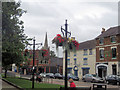
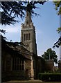
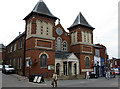
NN16 0AY represents a specific postcode area within the town of Kettering, located in Northamptonshire. This small residential cluster covers 7,946 square metres and houses 2,174 people. The location sits approximately eight miles north of Wellingborough and roughly 75 miles from London. Kettering itself received its market charter in 1227 from King Henry III, transforming from a medieval settlement into a substantial industrial centre by the 19th century. The historical name derives from Anglo-Saxon origins, meaning the people of Ketter. Life in this postcode is defined by its quiet, industrial heritage, which includes a history of shoe-making and iron-smelting dating back to Roman times. The area functions as part of a larger market town where Kettering station, opened in 1857, provides the primary railway connection to the rest of the region. For those looking at homes in NN16 0AY, the neighbourhood offers proximity to significant local landmarks without the noise of a busy city centre. The parish church of St Peter and St Paul dominates the town with its distinctive 180-foot spire, situated just off the Market Square. While the NN16 0AY postcode covers a limited geographical footprint, it provides access to historic sites like Toller Chapel and the Sawyer family's Manor House now functioning as a museum. Residents live within a community that balances historical significance with modern convenience. The area's small size creates a close-knit environment where neighbours are often aware of one another. Buying property here means joining a specific slice of a town with deep roots in trade and industry.
- Area Type
- Postcode
- Area Size
- 7946 m²
- Population
- 2174
- Population Density
- 7653 people/km²
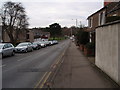
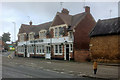
Homes in NN16 0AY reside within a predominantly owner-occupied sector, with 48% of residents holding the freehold title. The accommodation type consists of houses, which dominate the stock in this specific postcode. This high level of home ownership indicates a stable long-term residential market where families have established roots in the Kettering area. Buyers looking at homes in NN16 0AY are entering a market characterised by individual properties rather than high-density flats or blocks. The town of Kettering developed significantly during the 19th century, transforming from a modest medieval settlement into a substantial industrial centre. This historical progression shaped the housing stock into the houses seen today. The area sits within Northamptonshire, a region once famous for boot and shoe manufacturing. Thomas Gotch founded the shoe-making enterprise in 1778, an industry that later built factories in the Headlands and Rockingham areas, supporting residential terraced streets nearby. While these specific factories are historical features, the legacy of industrial housing remains relevant to the character of the surrounding neighbourhoods. Purchasing a property in NN16 0AY offers entry into a specific slice of this industrial heritage. The 48% ownership rate means there are active sales in a balanced market. There are no large blocks of rental flats dominating the immediate vicinity, ensuring a more residential atmosphere. For those considering second homes or moves into the East Midlands, the stock of houses provides a traditional British property experience. The small size of the postcode area, at 7,946 square metres, means buyers must act quickly when a suitable house comes to the market, as inventory at this level is naturally limited. The environment is quiet, mirroring the historical shift away from heavy industry towards a service-oriented and residential economy.
House Prices in NN16 0AY
No properties found in this postcode.
Energy Efficiency in NN16 0AY
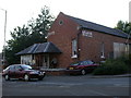
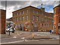
Daily life in NN16 0AY benefits from the convenience of several retail and transport options located within practical reach. Residents have access to five key retail venues, including Tesco Kettering, Morrisons Weekley, and Lidl Weekley. These supermarkets provide for all grocery needs without a long journey. A single bus interchange operates nearby, offering flexible options for getting around the wider town of Kettering. Crucially, Kettering Railway Station is just one rail stop away, connecting residents to the national network. This concentration of amenities means daily errands take minimal effort. Historical landmarks add cultural depth to the lifestyle available near NN16 0AY. The parish church of St Peter and St Paul features a distinctive 180-foot spire and sits just off the Market Square at the end of the High Street. This architectural feature provides a traditional focal point for neighbours visiting the town centre. Toller Chapel, built in 1723, serves as a reminder of the area's religious heritage, having been established for those worshipping since the 17th century. Educational establishments such as Tresham College in Windmill Road and a Grammar School serve the community, ensuring academic opportunities for local children. The area retains tangible links to its industrial past. The Sawyer family's Manor House in Sheep Street now functions as a museum, allowing residents to explore the history of the Sawyer family from the 17th century. Nearby is the Baptist Missionary Society, which emerged through figures such as Thomas Toller and Andrew Falls. Living in NN16 0AY offers a lifestyle that combines modern retail convenience with access to these historic sites. The proximity to a bus interchange and Kettering Railway Station ensures that while the postcode itself is small, the world of work and leisure is easily accessible. Grocery shopping at Tesco or Morrisons complements a day ended by a cultural visit to a historic chapel or museum.
Amenities
Schools
| Rank | School | Type | Entry gender | Ages |
|---|
Explore more schools in this area
Go to Schools tabDemographics
The community living in NN16 0AY has a distinct age profile. The median age is 47 years, with the most common age range being adults between 30 and 64 years. This demographic skew suggests the area attracts mature professionals and families rather than young students or retirees. House ownership stands at 48%, indicating that nearly half of the residents own their homes outright or with a mortgage, while the other half rent. This split reflects a typical mix seen in many established residential clusters across England. Accommodation types in NN16 0AY consist primarily of houses, which aligns with the historical development of the surrounding town into a residential area. The area lies within Northamptonshire, a county noted for its shoe and boot manufacturing heritage, which historically drove population growth to over 3,000 by 1801. The predominant ethnic group in NN16 0AY is White, reflecting the broader ethnic composition of the local catchment area. With a population density of 273,612 people per square kilometre, the area is statistically dense due to its very small size of 7,946 square metres, even though the absolute number of residents is modest at 2,174. Living in NN16 0AY means joining a community where adults form the backbone of the local economy and social life. The high proportion of adults aged 30 to 64 years implies a stable residential base with likely school-aged children living nearby. Families choosing homes in this postcode benefit from a mature neighbourhood where the majority of neighbours fall within working or post-working age. The 48% home ownership rate suggests a balanced market where selling an investment property or moving house is a common and active process. This demographic picture supports a quiet, settled lifestyle focused on stability rather than transient living.
Household Size
Accommodation Type
Tenure
Ethnic Group
Religion
Household Composition
Age
Household Deprivation
NS-SEC
Explore more demographic insights in this area
Go to Demographics tabPlanning
Planning Constraints
- Flood RiskPremium
- Ramsar Wetland SitesPremium
- Area of Outstanding Natural BeautyPremium
- Protected Nature ReservePremium
- Protected WoodlandPremium