Area Overview for NN1 1UX
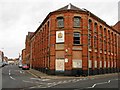
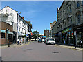
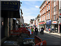
Photos of NN1 1UX


Area Information
Living in NN1 1UX means residing within a specific postcode area covering a small residential cluster with a total population of 2076. This compact environment offers a defined sense of community where daily life revolves around immediate local surroundings and direct access to Northampton's core facilities. The area functions as a dense settlement rather than a sprawling suburb, ensuring that residents can reach key services like shops, transport hubs, and leisure centres without extensive travel time. Its identity is shaped by high-density living and a strong reliance on public infrastructure to maintain connectivity with the wider city. Prospective homebuyers should recognise NN1 1UX as a solution for those prioritising proximity to urban amenities over spacious gardens or detached homes. The location sits in England, providing easy access to major road networks and the railway system that links Northampton to surrounding towns. While the population density is significant for such a small footprint, this concentration allows for efficient use of local resources and a vibrant, walkable neighbourhood feel. For anyone considering moving here, the area demands a practical understanding of its scale and what life entails within these close-kitted streets. It is a place defined by its integration into the broader fabric of Northampton, offering convenience alongside the constraints of dense urban living.
- Area Type
- Postcode
- Area Size
- Not available
- Population
- 2076
- Population Density
- 4514 people/km²
The property market in NN1 1UX is fundamentally a rental estate rather than one dominated by owner-occupiers. With home ownership standing at only 25% of the total population, the housing stock is primarily rented out. This market dynamic dictates that the vast majority of available properties are flats, as this is the predominant accommodation type recorded for the area. You are unlikely to find a vast number of detached or semi-detached houses; instead, expect apartment living to be the standard choice for buyers or tenants in this postcode. If you are looking at homes in NN1 1UX, understand that this is a high-density residential cluster designed for efficient urban living. The lack of owner-occupancy suggests a lack of long-term family settlement in the traditional sense. Prospective buyers must recognise that entering this market often means purchasing within the private rental sector or buying a minority of available properties that have been converted to owner-occupied status. The concentration of flats means that interior layout and building age are key factors, as drive space and large gardens are uncommon assets. For those seeking stability, the low ownership rate indicates you may be moving into a neighbourhood where people are more likely to change residences frequently.
House Prices in NN1 1UX
No properties found in this postcode.
Energy Efficiency in NN1 1UX
Living in NN1 1UX places you within reach of significant retail and leisure hubs in Northampton. You have direct access to five major retail outlets, including Tesco Northampton, Morrisons Northampton, and Iceland Northampton FWH. These supermarkets ensure you can stock your kitchen at the start of the day or top up essentials late in the evening. The concentration of these supermarkets makes self-sufficiency easy and minimises the need for long car journeys for grocery shopping. Transport options further enhance your daily lifestyle with two dedicated bus services connecting to the Northampton Bus Interchange and the University Bus Interchange. A single rail link to Northampton Railway Station provides a direct connection to the national rail network. If you prefer not to use public transport, reputable retailers and services cluster close by the residential area. This proximity means your daily errands are solved within walking distance or a short bus ride. The immediate amenity count supports a convenient urban lifestyle where living in NN1 1UX offers practical access to food, travel, and daily necessities without the isolation of rural living.
Amenities
Schools
Families considering NN1 1UX have two specific schools immediately nearby, each serving a different educational purpose. Parkside Independent School is an independent institution located close to the postcode. Its independent status means it offers a private education model which typically requires fee payment rather than local council funding. Nearby, you will also find WiEducate LTD, which operates as a special school. This facility is designed to support students with specific educational needs rather than the general school student population. The mix of one independent school and one special school near NN1 1UX means the area does not cater to the local state sector for primary or secondary education within its immediate bounds. You cannot rely on local reception intake for a mainstream state Primary or Secondary school based solely on this data. This forces residents to consider transport logistics if they wish to send children to nearby mainstream schools not listed in this specific dataset. The presence of these two institutions serves a niche market, providing options for those seeking private education or special educational provisions. Families evaluating schools near NN1 1UX must verify the catchment areas of broader municipal schools if their children require mainstream state education, as the local provision is limited to these two specific entities.
| Rank | School | Type | Entry gender | Ages |
|---|
Explore more schools in this area
Go to Schools tabDemographics
The community in NN1 1UX presents a distinct demographic profile characterised by a median age of 22 years. You will find that the most common age range among residents falls between 30 and 64 years, suggesting a significant presence of young adults and mid-century workers living together or nearby. This population shows a relatively low level of home ownership, standing at an exact 25% of residents. Consequently, the majority of the community either rents their accommodation or lives with family members. This directly correlates with the predominant accommodation type, which consists of flats rather than single-family houses. You should expect a diverse living arrangement where the majority of households do not own their property outright. The demographic data indicates that White residents form the predominant ethnic group within this postcode. While the area hosts a mix of families and professionals in the 30-to-64 bracket, the lower ownership rate suggests many residents are in temporary accommodation or share properties. This environment often supports a transient or evolving population compared to established owner-occupied communities. The combination of a young median age and flat-based housing points towards an area catering to students, young professionals, or individuals seeking affordable rental options within the Northampton region.
Household Size
Accommodation Type
Tenure
Ethnic Group
Religion
Household Composition
Age
Household Deprivation
NS-SEC
Explore more demographic insights in this area
Go to Demographics tabPlanning
Planning Constraints
- Flood RiskPremium
- Ramsar Wetland SitesPremium
- Area of Outstanding Natural BeautyPremium
- Protected Nature ReservePremium
- Protected WoodlandPremium