Area Overview for NN1 1TP
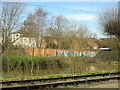
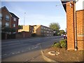
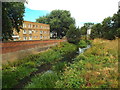
Photos of NN1 1TP


Area Information
Living in NN1 1TP means residing within a very compact residential cluster of just 0.004 square kilometres. This postcode covers a total area size of only 4017 square metres, creating a dense and tightly knit environment. The location hosts a population of 1498 people, resulting in a population density of 1365 people per square kilometre. You will find this specific postcode area covers a small residential cluster rather than sprawling suburbs. The high density implies narrow streets, close proximity to neighbours, and a lack of open green space within the immediate boundaries. Daily life here is defined by the concentration of residents in a limited footprint compared to wider NN1 neighbourhoods. You are entering a defined space where everyone is effectively a neighbour because the homes sit so close together. This compactness offers convenience but can also mean limited privacy if you seek a detached home with extensive grounds. The area serves as a specific residential hub within the broader NN1 region, characterised by its intense urban packing. When you consider homes in NN1 1TP, you must acknowledge that you are purchasing into a finished, built-up environment rather than developing land. The sheer number of people per square metre shapes the rhythm of the street, dictating noise levels, footfall, and the general urban texture of your future address.
- Area Type
- Postcode
- Area Size
- 4017 m²
- Population
- 1498
- Population Density
- 1365 people/km²
The property market in NN1 1TP is characterised predominantly by private sector renting rather than owner-occupation. With home ownership sitting at just 11%, you will find that the vast majority of homes in NN1 1TP are let properties. This statistic defines the economic reality of the area as a rental hub where tenants hold the majority of keys. You should anticipate finding a high volume of available flats for rent rather than houses for sale when you search this specific postcode. The 11% ownership figure also implies that the market dynamics are driven more by tenant turnover and rental yields than by house price appreciation or equity building. Predominant accommodation types in this postcode are flats. The physical layout of NN1 1TP consists almost exclusively of multi-storey residential blocks rather than standalone houses. This housing stock is a direct result of the need to accommodate 1498 people within a mere 4017 square metres of land. When you examine homes in NN1 1TP, you are looking at an urban environment designed for efficiency and density. The lack of detached or semi-detached properties means that buyers looking for traditional garden estates will not find matches here. Consequently, the property market serves commuters and singles who value central location over land ownership. You must consider the implications of a 11% owner occupancy rate before committing to a rental agreement here. Tenants in this area form a stable majority, which can lead to well-maintained blocks and engaged resident associations. However, the high density of rental units also means that lease terms and service charges are the primary levers of cost control. If you are looking to move into NN1 1TP, your primary focus must be on leasehold arrangements and ground rents rather than mortgages and land savings. The housing stock reflects a deliberate urban planning approach that prioritises volume over space, making flats the only viable option for serious consideration.
House Prices in NN1 1TP
No properties found in this postcode.
Energy Efficiency in NN1 1TP
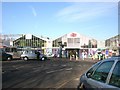
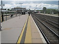
Daily life in NN1 1TP is serviced by a practical cluster of amenities located within walking distance. Your immediate retail options include Spar, Lidl Central, and Iceland Northampton FWH. These five retail outlets provide everything you need for weekly grocery shopping and everyday necessities. You can stock your kitchen and household requirements without leaving the local postcode area. The presence of Lidl Central ensures competitive pricing for larger households, while the Iceland store offers fresh produce and meat products right on your doorstep. Transport and leisure facilities are similarly accessible through two major bus interchanges: the Northampton Bus Interchange and the University Bus Interchange. These hubs place you within minutes of wider cultural and commercial districts in Northampton. The proximity to a university also suggests a youthful energy and student-friendly atmosphere despite the older median age of local residents. You may encounter young professionals and academic staff blending into the 1365 people per square kilometre population. This mix ensures that local shops remain vibrant with footfall throughout the day. For those commuting, Northampton Railway Station is a key feature of the lifestyle. The train station provides rapid access to London and other commercial centres, making this postcode an attractive option for commuters who do not want the time cost of driving. You can start your day with a quick walk to the bus or rail interchange rather than an hour-long drive. The combination of nearby shops, efficient public transport, and good broadband creates a convenient self-contained lifestyle. Living in NN1 1TP means you have your essentials at your fingertips, supported by a transport network that connects you to the wider region effortlessly.
Amenities
Schools
| Rank | School | Type | Entry gender | Ages |
|---|
Explore more schools in this area
Go to Schools tabDemographics
The community in NN1 1TP reflects an older demographic profile with a median age of 47 years. Adults between the ages of 30 and 64 years represent the most common age range within the population. This statistical pattern suggests the area attracts professionals and established families rather than young students or retirees. Despite the higher average age, you will find a balanced mix of households rather than an exclusively elderly cohort. The predominant ethnic group in NN1 1TP is White, accounting for the majority of the 1498 residents recorded in this specific postcode. Home ownership stands at a low level of 11% within this cluster. This figure indicates that nearly nine out of ten living arrangements are rented properties. You should approach this area with the expectation that you are entering a rental market dominated by long-term tenants. The low ownership rate often correlates with secure, established communities where residents prioritize stability over building equity. This dynamic can foster a calm residential atmosphere, but it may also influence local planning if ownership concentrations are needed for infrastructure investment. When you look at the accommodation type for NN1 1TP, flats are the defining feature of the housing stock. You will not find traditional terraced or detached houses as the primary dwelling type here. Instead, the building stock consists largely of multi-storey units designed to house many people within the small 4017 square metre footprint. Living in NN1 1TP means sharing common walls, stairwells, and amenities with other residents. The flat living arrangement provides efficient use of space in this high-density zone but requires noise discipline from neighbours. Homes in NN1 1TP are therefore urban apartments suited to commuters and city-dwelling professionals rather than families seeking gardens.
Household Size
Accommodation Type
Tenure
Ethnic Group
Religion
Household Composition
Age
Household Deprivation
NS-SEC
Explore more demographic insights in this area
Go to Demographics tabPlanning
Planning Constraints
- Flood RiskPremium
- Ramsar Wetland SitesPremium
- Area of Outstanding Natural BeautyPremium
- Protected Nature ReservePremium
- Protected WoodlandPremium