Area Overview for NG9 1BF
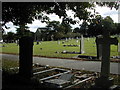
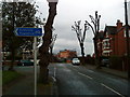
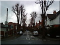
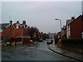
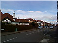
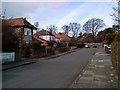
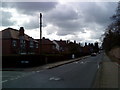
Photos of NG9 1BF

Area Information
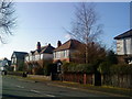
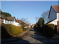
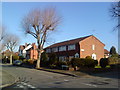
Living in NG9 1BF means residing within a defined postcode area that covers a small residential cluster just outside Nottingham. This specific location holds a population of 1,747 people, creating a compact neighbourhood where residents know their immediate surroundings well. The area functions as a distinct pocket of community life, separate from the wider city centre yet connected by robust transport links. You will find that daily life here revolves around practical convenience and established local routines. The small scale of the population ensures that local services remain accessible without the congestion of larger urban zones. This residential cluster provides a setting where you can maintain a connection to a larger city while enjoying the quieter atmosphere of a defined home zone. When you consider homes in NG9 1BF, you are entering an established living environment rather than a developing site. The concentration of residents in this postcode creates a sense of stability and permanence that appeals to those seeking a foothold in the Nottingham region. Local knowledge suggests that the character of this area is shaped by its history as a residential pocket rather than a commercial hub. The community benefits from being close to major transport arteries and shopping centres, yet it retains its own identity as a specific slice of the Greater Nottingham landscape. Whether you are arriving for the first time or moving from a nearby postcode, the area offers a settled environment where the pace of life is dictated by conventional working hours and local commitments.
- Area Type
- Postcode
- Area Size
- Not available
- Population
- 1747
- Population Density
- 5814 people/km²
This small area functions primarily as an owner-occupied market rather than a rental hotspot. With a home ownership percentage of 85%, the housing stock in NG9 1BF is overwhelmingly composed of families or individuals who have purchased their homes. This imbalance between owners and renters means that the local property market is driven by second-hand transactions and inheritance rather than new build introductions or private leasing. You will encounter mostly houses as the predominant accommodation type, with very few flats or purpose-built apartments listed for sale. When searching for homes in NG9 1BF, you are competing against a pool of buyers who typically prioritise stability and long-term investment over quick moves. The fact that 85% of residents own their homes indicates that prices in this postcode are set by traditional market valuations rather than speculative rental yields. This environment suits buy-to-let investors looking for established assets, but it may limit the availability of rental options for single professionals or new migrants. The residential cluster nature of this postcode means that listings will often target specific requirements such as family homes or elderly residences. Buyers looking at this area should expect a slower but more deliberate sales process due to the entrenched nature of the local owner-occupier base. The properties on offer here stand as lasting investments rather than temporary accommodations.
House Prices in NG9 1BF
No properties found in this postcode.
Energy Efficiency in NG9 1BF
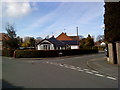
Daily life in NG9 1BF benefits from immediate access to a wide range of retail and transport venues, all within practical reach. Residents have five retail outlets nearby, including major supermarkets like Lidl Beeston, Sainsburys Beeston, and Tesco Nottingham. These grocery stores are anchored in the nearest shopping locations, providing staples and essentials without the need for long journeys. Your weekly shop is reachable within a short drive or cycle ride, integrating seamlessly into your routine. Beyond food, you enjoy excellent public transport links with five metro and rail options close by. Beeston Centre Tram Stop and the Tram & Bus Interchange offer direct connections into Nottingham city centre and onward travel. For commuters, Beeston Railway Station and Attenborough Railway Station act as key nodes to the national rail network, while Nottingham Railway Station provides access to the wider East Midlands Expressway. Nottingham Airport is also a notable facility just one distance away, allowing for regional travel without relying solely on rail services. These five rail stations and multiple tram stops ensure that you can leave your home in NG9 1BF and reach central business districts or airports with minimal delay. The concentration of amenities creates a self-contained lifestyle where major errands do not require an hour-long journey. You can handle your shopping, commuting, and travel needs from the doorstep of this residential cluster, maintaining a balance between local convenience and wider connectivity.
Amenities
Schools
| Rank | School | Type | Entry gender | Ages |
|---|
Explore more schools in this area
Go to Schools tabDemographics
The community in NG9 1BF is defined by a mature and stable age profile. The median age of residents is 47 years, which places the area significantly above the national average. Most commonly, the population consists of adults aged between 30 and 64 years, indicating a demographic dominated by individuals in their prime working or retirement years. This age structure suggests a neighbourhood where families may be raising younger children or empty-nesters enjoying their independence without the immediate pressures of younger adulthood. The high percentage of home ownership stands at 85%, meaning you are nine times more likely to find an owner-occupied property than a rental fitting within this specific postcode boundary. Houses form the primary accommodation type in NG9 1BF, reflecting the needs of the adult population residing there. This focus on detached or semi-detached housing aligns with the buying preferences of the 30 to 64 age group who control household finances. The predominant ethnic group is White, which mirrors the broader demographic trends of the East Midlands region. The high level of home ownership also signals long-term settlement patterns rather than short-term tenancy arrangements. You will find that 85 out of every 100 properties here have remained in the same hands for extended periods. This stability often correlates with well-maintained properties and a community invested in the local environment. The social fabric is woven from residents who have likely lived in this specific cluster for many years.
Household Size
Accommodation Type
Tenure
Ethnic Group
Religion
Household Composition
Age
Household Deprivation
NS-SEC
Explore more demographic insights in this area
Go to Demographics tabPlanning
Planning Constraints
- Flood RiskPremium
- Ramsar Wetland SitesPremium
- Area of Outstanding Natural BeautyPremium
- Protected Nature ReservePremium
- Protected WoodlandPremium