Area Overview for NG7 5EQ
Photos of NG7 5EQ


Area Information
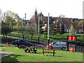
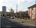
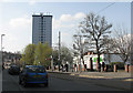
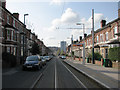
Living in NG7 5EQ means residing in a compact residential cluster with a total population of 1,635 people. This specific postcode area concentrates housing within a small footprint, offering a sense of locality while maintaining proximity to wider Nottinghamshire services. The neighbourhood is defined by its density, where residents share close proximity to one another rather than sprawling across a vast zone. Daily life revolves around accessibility, with key amenities and transport hubs positioned within practical reach. You can walk to major supermarkets, tram stops, and railway stations without undertaking significant journeys into the city centre. The environment is primarily urban residential, lacking extensive green corridors or isolated rural stretches. Instead, the area functions as a functional node within the Hyson Green and Alfreton corridor. For those considering homes in NG7 5EQ, the layout prioritises access over isolation. The community benefits from immediate connections to the tram network and rail links to Nottingham. This connectivity is as defining a feature as the housing stock itself. The area does not boast large parks or historic landmarks within its immediate bounds, but it compensates with efficient access points for commuting and shopping. You will find that the neighbourhood operates as a busy transit zone where residents value convenience and direct routes. The character is straightforward and practical, serving commuters and families who require reliable links to employment centres. Understanding this layout helps you gauge what living in this specific postal sector entails.
- Area Type
- Postcode
- Area Size
- Not available
- Population
- 1635
- Population Density
- 13524 people/km²
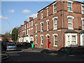
The property market in NG7 5EQ is characterised by low ownership rates, with only 23% of residents owning their homes. This figure indicates that the area functions largely as a rental hub rather than an owner-occupied community. The majority of the housing stock consists of houses, which contrasts with flats or apartments found in denser urban cores. For buyers looking at homes in NG7 5EQ, the landscape suggests limited opportunities for owner-occupiers compared to the rental sector. The local market is driven by tenants who require flexible accommodation near transport links and employment centres. Finding a house here often involves navigating a competitive rental space rather than a straightforward purchase market. The predominance of houses means the architectural style is likely consistent, focusing on standalone or semi-detached structures suitable for small families or single adults. You may face challenges securing a mortgage or a property sale deal given the low ownership percentage. The area does not present itself as an exclusive enclave for investors seeking high capital appreciation through buy-to-let strategies alone. Instead, the market reflects the needs of a younger, mobile population. If you are considering purchasing a home in NG7 5EQ, you must accept that the 23% ownership rate defines the current economic reality of the postcode.
House Prices in NG7 5EQ
No properties found in this postcode.
Energy Efficiency in NG7 5EQ
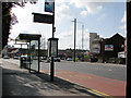
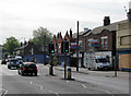
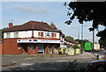
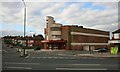
Residents of NG7 5EQ enjoy a wide range of amenities within practical reach. Retail options are plentiful with five local shops, including Tesco Alfreton, Aldi Hyson, and Asda Hyson. These supermarkets provide essential shopping needs without requiring long journeys. Transport hubs dominate the immediate vicinity, with five metro stops and five rail stations available. You can access Hyson Green Market Tram Stop, Noel Street Tram Stop, and Radford Road Tram Stop for quick trips into the city. Nottingham Railway Station, Bulwell Railway Station, and Beeston Railway Station offer extensive rail connections. Additionally, a single airport, Nottingham Airport, sits nearby for travel requirements. This concentration of services means daily life revolves around convenience and efficiency. You do not need to leave the area for basic shopping or transport needs. The presence of major chains like Aldi and Asda ensures competitive pricing and variety. The tram and rail network extends the living radius significantly, giving you access to workplaces and leisure venues across the wider region. While the immediate neighbourhood may not have parks or cafes listed in the data, the transport links effectively bring these amenities within reach. Living in NG7 5EQ prioritises functional accessibility over a leisure-focused local environment.
Amenities
Schools
Families considering homes in NG7 5EQ will find two primary schools within easy reach. Bentinck Primary and Nursery School serves the younger demographic with early education and childcare facilities. Nearby, the Bluecoat Bentinck Primary Academy offers further primary schooling options for children. Both institutions are located in close proximity to the residential cluster, ensuring short commutes to class. The presence of these two primary schools indicates a focus on early years education for the local population. There are no secondary schools listed in the immediate vicinity of NG7 5EQ, meaning older children will likely travel to secondary institutions outside the postcode area. The mix of schools available highlights the role of NG7 5EQ as a community for very young families. You will need to look beyond the immediate postcode for secondary education options. However, having Bentinck Primary and Nursery School and Bluecoat Bentinck Primary Academy nearby supports parents with young children. These schools provide a foundation for early learning before families move to larger districts for secondary schooling. The accessibility of these facilities is a key practical consideration for residents. You should verify travel distances and catchment areas directly with the schools to plan your move effectively.
| Rank | School | Type | Entry gender | Ages |
|---|---|---|---|---|
| 1 | Bentinck Primary and Nursery School | primary | N/A | N/A |
| 2 | Bluecoat Bentinck Primary Academy | primary | N/A | N/A |
Explore more schools in this area
Go to Schools tabDemographics
The community in NG7 5EQ displays a distinct age profile with a median age of just 22 years. Despite this low median figure, adults between the ages of 30 and 64 remain the most common age range within the population. This suggests a concentration of young professionals or students living independently alongside older residents. House ownership stands at a low 23%, indicating that the majority of residents rent their accommodations rather than own their homes. The prevailing accommodation type consists of houses, which forms the backbone of the local housing stock. Ethnic diversity is evident, with the Asian total group forming the predominant ethnic community in the area. This demographic mix creates a dynamic social environment where younger households coexist with older residents. The high volume of renters implies a transient or rental-heavy market rather than a stable owner-occupier neighbourhood. You will encounter a population that includes many young adults, potentially drawn by the proximity to universities or employment hubs in Nottingham. The presence of adult residents in the 30 to 64 bracket suggests a mix of established families and long-term tenants. Houses dominate the scene, meaning you are less likely to find high-rise flats or terraced rows than you might in a dense city centre district. This combination of house ownership types and age groups paints a picture of a residential zone built for practical living rather than exclusive luxury.
Household Size
Accommodation Type
Tenure
Ethnic Group
Religion
Household Composition
Age
Household Deprivation
NS-SEC
Explore more demographic insights in this area
Go to Demographics tabPlanning
Planning Constraints
- Flood RiskPremium
- Ramsar Wetland SitesPremium
- Area of Outstanding Natural BeautyPremium
- Protected Nature ReservePremium
- Protected WoodlandPremium
- Crime RiskPremium