Area Overview for NG5 2BT
Photos of NG5 2BT

Area Information
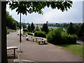
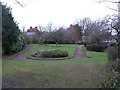
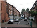
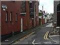
NG5 2BT is a small, densely populated residential cluster within Nottinghamshire. This specific postcode covers just over 0.005 square kilometres, yet it accommodates 1,929 residents. The resulting population density stands at 382,533 people per square kilometre, indicating a tightly packed environment. Living in NG5 2BT means navigating a compact area where neighbours are frequently within sight and sound. The location functions primarily as a sitting area rather than a destination for commercial activity. Daily life revolves around movement to nearby town centres for shopping or entertainment. Despite its size, the area supports a defined community with distinct demographic characteristics. You will find established residents rather than students or transient populations typical of larger student zones. The high density ensures vibrant street volumes even during quieter hours. This postcode represents a specific slice of the wider Nottingham housing corridor. Its compact nature offers convenience but can limit private outdoor space. Understanding these physical parameters helps you gauge daily logistical demands.
- Area Type
- Postcode
- Area Size
- 5043 m²
- Population
- 1929
- Population Density
- 5741 people/km²
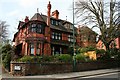
The property market in NG5 2BT is defined by a significant proportion of first-home buyers or renters. With home ownership sitting at 42%, the private owner-occupied sector is substantial but not absolute. Flats represent the predominant accommodation type for this postcode. This suggests that urban-style living or conversion-style housing is common here. You will encounter fewer detached or semi-detached family homes compared to larger suburban areas. The high density of 382,533 people per square kilometre reinforces this flat-heavy market dynamic. Buyers seeking ground-floor access or low-maintenance housing will find this area suitable. Conversely, those seeking large gardens or significant indoor space may find limited options. The mix of ownership indicates a balanced market between investors and owner-occupiers. Rental demand remains active given the 58% non-owner-occupied rate. Your search for homes in NG5 2BT should prioritise vertical living solutions. Understanding this stock distribution prevents disappointment regarding property style.
House Prices in NG5 2BT
No properties found in this postcode.
Energy Efficiency in NG5 2BT
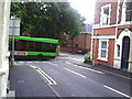
The lifestyle in NG5 2BT relies heavily on amenities within immediate reaches. Retail options include Lidl Sherwood, Co-op Carrington, and Tesco Nottingham. These supermarkets provide comprehensive grocery needs without requiring long journeys. Transport infrastructure links the area to broader networks through multiple metro stops. High School Tram Stop, Noel Street Tram Stop, and Forest Tram Stop offer rapid transit connections. Rail access via Nottingham Railway Station, Bulwell Railway Station, and Netherfield Railway Station expands commuting horizons. Nottingham Airport remains a minor but notable amenity for occasional air travel. You can access diverse shopping and transport networks within a short distance. The concentration of five retail outlets and five metro stops creates a convenient local hub. Daily errands remain manageable without extensive travel time. This accessibility defines the practical reality of living in this postcode.
Amenities
Schools
Families in NG5 2BT have access to a specific, limited selection of nearby educational institutions. Lutland House School serves as a special education provider for the area. Nearby families can also access Jamia Al-Hudaa Residential College, which holds a satisfactory Ofsted rating. This institution operates as an independent school providing residential support. Darul Amaanah stands as another independent option close to the postcode. The local school mix heavily features independent provision rather than large state comprehensive academies. This configuration may appeal to families seeking smaller class sizes or private education paths. The presence of a special needs facility indicates proximity to tailored educational resources. You should verify year-group availability directly with each institution during your move. The localized nature of these schools means shorter daily commutes for children. Transport links to these sites are essential for daily routines.
| Rank | School | Type | Entry gender | Ages |
|---|
Explore more schools in this area
Go to Schools tabDemographics
The community in NG5 2BT reflects an established residential demographic with a median age of 47 years. Adults between 30 and 64 years constitute the most common age range for residents. This age profile suggests a stable neighbourhood dominated by families and empty nesters rather than young professionals. Home ownership levels stand at 42%, meaning slightly less than half of the residents own their properties outright. The remaining majority likely reside in rental accommodation. Flats constitute the predominant accommodation type within the postal code. This housing stock preference aligns with the high density found in the area. White residents form the predominant ethnic group within this specific cluster. You will find a established community where long-term residency appears common. The demographic data paints a picture of a settled population. Age constraints may affect local leisure facility usage patterns. The mix of homeowners and renters creates a varied interest profile within the limited residential footprint.
Household Size
Accommodation Type
Tenure
Ethnic Group
Religion
Household Composition
Age
Household Deprivation
NS-SEC
Explore more demographic insights in this area
Go to Demographics tabPlanning
Planning Constraints
- Flood RiskPremium
- Ramsar Wetland SitesPremium
- Area of Outstanding Natural BeautyPremium
- Protected Nature ReservePremium
- Protected WoodlandPremium