Area Overview for NG5 1FF
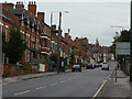
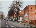
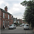
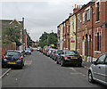
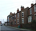
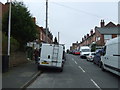
Photos of NG5 1FF


Area Information
Living in NG5 1FF means residing within a specific postcode covering a small residential cluster in England. This area forms a compact part of the wider Nottingham landscape, catering to a population of roughly 2,500 people. You will find a neighbourhood defined more by its intimate scale and distinct residential nature than broad urban sprawl. The cluster offers a sense of locality where daily routines typically centre on local streets and familiar neighbourhood points. Its size limits through-traffic while maintaining a close connection to surrounding infrastructure. Residents here navigate a community that functions as a distinct entity yet remains integrated into the broader city fabric. The area does not claim vast open spaces or historic grandeur; instead, it offers a focused residential environment. You can expect a setting where the distance to key services remains manageable without the congestion found in larger districts. For those seeking a contained living arrangement, this postcode provides a practical slice of suburban life near Nottingham. The character is one of straightforward residential living, avoiding the noise and density of commercial hubs while staying within practical reach of essential transport and retail links.
- Area Type
- Postcode
- Area Size
- Not available
- Population
- 2500
- Population Density
- 6626 people/km²
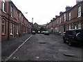
The property market in NG5 1FF is characterised by a strong leaning towards owner-occupation. With 61% of homes owned by their residents, this postcode operates as a genuine residential market rather than a corporate rental estate. The accommodation type is exclusively houses, which defines the character of the streets and the nature of any available listings. If you are browsing for homes in NG5 1FF, you will encounter family-sized dwellings and larger plots typical of established suburbs. This is not a cluster of flats or convertibles; the physical structure of the neighbourhood supports private gardens and independent living. For buyers looking at this small area, the high ownership rate suggests that inventory may rotate slowly as opposed to the turnover seen in student zones. Existing owners are likely selling only under specific circumstances, meaning new purchases into the area might require a prepared buyer. The dominance of houses implies that you will be competing with other homeowners for similar property types. This housing stock supports a lifestyle involving car usage or cycling rather than walking from a flat to amenities. The market here values stability and permanence. Anyone considering buying should note that the nature of the homes and the prevalence of owners make this a serious investment market.
House Prices in NG5 1FF
No properties found in this postcode.
Energy Efficiency in NG5 1FF
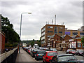
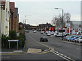
Your daily lifestyle in NG5 1FF is supported by a variety of amenities within practical reach. For shopping, you have five retail outlets nearby, including Tesco Nottingham, Co-op Carrington, and Lidl Sherwood. These supermarkets provide essential groceries and household necessities without requiring a long journey into Nottingham city centre. You can fill your weekly shopping list with ease. For travel, five metro stops serve the area, specifically Beaconfields Street Tram Stop, Shipstone Street Tram Stop, and Noel Street Tram Stop. These points of access connect you to the wider tram network efficiently. Rail travel is similarly convenient with Nottingham Railway Station, Bulwell Railway Station, and Carlton Railway Station situated close by for train commuters. If you need air travel, Nottingham Airport is a short distance away, acting as a key gateway for regional flights. This concentration of services means you do not need a car for all your needs, though a vehicle may still be useful for the residential nature of the homes. The proximity of these major retailers and transport nodes gives the area a convenient urban footprint despite its small postcode size. Residents enjoy the ability to live in a quiet neighbourhood while staying close to the commercial and transport engine of Nottingham. You will find your shops and stations are never far from your doorstep.
Amenities
Schools
Families in NG5 1FF have access to a specific set of educational options nearby. The Alternative Provision PRU serves as a special educational resource within the immediate vicinity, catering to students requiring alternative learning environments. For independent education, you will find FUEL, which holds a 'good' Ofsted rating. This independent institution offers an alternative to the state sector for parents seeking specific educational pathways. The mix of school types in the area means that choices are limited to these two specific institutions listed for the postcode. You will not find secondary schools or primary academies explicitly named in the data for this cluster, so parents must rely on these known providers or broader district allocations. The presence of an Alternative Provision PRU indicates support for students who cannot follow standard curriculum routes, while the independently rated FUEL suggests a private or special need alternative for others. When planning for children, you will need to understand that the school options are distinct from typical neighbourhood primary schools. The 'good' rating for FUEL provides assurance for families choosing that pathway. However, the narrowness of the listed school types means you must verify durability of attendance and transport routes for other educational institutions. Living here requires clear knowledge of how these specific schools interact with the local catchment boundaries.
| Rank | School | Type | Entry gender | Ages |
|---|
Explore more schools in this area
Go to Schools tabDemographics
The community in NG5 1FF is shaped by a clear demographic profile with a median age of 47. Most residents fall into the adult age range between 30 and 64 years, suggesting families and professionals who have settled down. This age distribution indicates a stable population rather than a transient student-led demographic. Home ownership stands at 61%, meaning nearly two-thirds of the households own their property outright or have a significant stake in their home. This high rate points to a settled community with long-term residents who have invested in the local estate. Accommodation in the area consists of houses, which aligns with the homeownership statistics and the age profile. You will find detached or semi-detached properties rather than high-rise flats or temporary housing units. The predominant ethnic group is White, reflecting the traditional composition of the housing stock in this part of Nottingham. This homogeneity contributes to a consistent cultural fabric within the cluster. The demographic data paints a picture of a mature neighbourhood where households are likely established. With two-thirds of residents owning homes, you may notice well-maintained properties and gardens that reflect a commitment to the local environment. The lack of significant youth or retirement demographics suggests a balanced, working-age family orientation.
Household Size
Accommodation Type
Tenure
Ethnic Group
Religion
Household Composition
Age
Household Deprivation
NS-SEC
Explore more demographic insights in this area
Go to Demographics tabPlanning
Planning Constraints
- Flood RiskPremium
- Ramsar Wetland SitesPremium
- Area of Outstanding Natural BeautyPremium
- Protected Nature ReservePremium
- Protected WoodlandPremium