Area Overview for NG17 1JE
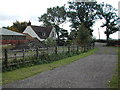
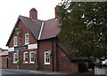
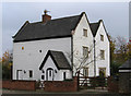
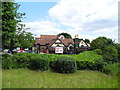
Photos of NG17 1JE


Area Information
NG17 1JE is a small, tightly packed residential area in England, covering just 4.4 hectares. With a population of 2,625 and a density of 1,992 people per square kilometre, it is a compact community where proximity to amenities and transport is a defining feature. The area is home to a mature population, with a median age of 47 and the majority of residents aged between 30 and 64. This suggests a stable, established community with strong ties to local services and infrastructure. The high home ownership rate of 87% indicates a preference for long-term residency, with most properties being houses rather than flats. Living here means being within walking distance of multiple retail outlets, including Tesco Sutton, Spar, and Co-op Sutton, as well as several railway stations. The area’s small size and high connectivity make it ideal for those seeking convenience without sacrificing space or accessibility.
- Area Type
- Postcode
- Area Size
- 4.4 hectares
- Population
- 2625
- Population Density
- 1992 people/km²
The property market in NG17 1JE is dominated by owner-occupied homes, with 87% of properties owned by residents rather than rented. This high rate of home ownership suggests a community focused on long-term residency, with fewer short-term rental properties. The accommodation type is exclusively houses, which is unusual for a small postcode area and indicates a preference for single-family homes. This makes NG17 1JE distinct from nearby areas that might have more flats or shared housing. For buyers, this means the market is likely to be competitive for those seeking a house in a compact, well-connected location. The small size of the area also means that properties are closely spaced, and the immediate surroundings may offer similar housing stock. Buyers should consider the limited availability of new builds, given the area’s established character.
House Prices in NG17 1JE
Showing 28 properties
| Address | Type | Beds | Baths | Last Sale Price | Last Sale Date | |
|---|---|---|---|---|---|---|
| 308 Alfreton Road, Sutton In Ashfield, NG17 1JE | Semi-detached | 3 | 1 | £172,425 | Mar 2025 | |
| 352 Alfreton Road, Sutton In Ashfield, NG17 1JE | Detached | 3 | 1 | £125,000 | Oct 2020 | |
| 300 Alfreton Road, Sutton In Ashfield, NG17 1JE | Semi-detached | 3 | 1 | £157,000 | Sep 2019 | |
| 320 Alfreton Road, Sutton In Ashfield, NG17 1JE | Semi-detached | 5 | 2 | £235,000 | Aug 2018 | |
| 326 Alfreton Road, Sutton In Ashfield, NG17 1JE | Detached | 4 | - | £362,500 | Nov 2017 | |
| Holmcroft, Alfreton Road, Sutton In Ashfield, NG17 1JE | Bungalow | - | - | £157,000 | Feb 2011 | |
| 306 Alfreton Road, Sutton In Ashfield, NG17 1JE | Semi-detached | - | - | £58,950 | May 2000 | |
| 346 Alfreton Road, Sutton In Ashfield, NG17 1JE | Detached | 4 | 2 | £89,950 | Dec 1999 | |
| 312 Alfreton Road, Sutton In Ashfield, NG17 1JE | Detached | - | - | £65,000 | Nov 1999 | |
| 358 Alfreton Road, Sutton In Ashfield, NG17 1JE | Detached | 3 | 1 | - | - |
Energy Efficiency in NG17 1JE
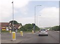
Daily life in NG17 1JE is shaped by its proximity to essential retail and transport hubs. The area’s five retail outlets, including Tesco Sutton, Spar, and Co-op Sutton, provide easy access to groceries, convenience goods, and other necessities. These shops are within practical walking distance, reducing the need for long commutes. The five nearby railway stations, such as Sutton Parkway and Alfreton, offer frequent services, connecting residents to broader regional networks. While the data does not mention parks or leisure facilities, the compact nature of the area suggests that residents rely on nearby towns for more extensive amenities. The combination of retail convenience and rail connectivity makes NG17 1JE a practical choice for those prioritising accessibility over large-scale leisure options.
Amenities
Schools
| Rank | School | Type | Entry gender | Ages |
|---|
Explore more schools in this area
Go to Schools tabDemographics
The population of NG17 1JE is predominantly composed of adults aged 30 to 64, reflecting a mature, settled community. With a median age of 47, the area is not heavily populated by younger families or retirees, which shapes its social dynamics and local needs. Home ownership is exceptionally high at 87%, suggesting a strong sense of stability and long-term commitment among residents. The accommodation type is primarily houses, which aligns with the area’s character as a residential cluster rather than a high-density housing zone. The predominant ethnic group is White, which influences the cultural and social fabric of the neighbourhood. The absence of specific data on deprivation means that quality of life is inferred from the high home ownership and low crime risk, indicating a generally secure and self-sufficient community.
Household Size
Accommodation Type
Tenure
Ethnic Group
Religion
Household Composition
Age
Household Deprivation
NS-SEC
Explore more demographic insights in this area
Go to Demographics tabPlanning
Planning Constraints
- Flood RiskPremium
- Ramsar Wetland SitesPremium
- Area of Outstanding Natural BeautyPremium
- Protected Nature ReservePremium
- Protected WoodlandPremium