Area Overview for NG16 1BP
Photos of NG16 1BP
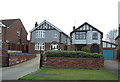
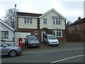
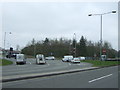
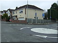
57 photos from this area
Area Information
Key information about the NG16 1BP including its size, population, and administrative classification.
- Area Type
- Postcode
- Area Size
- 1.5 hectares
- Population
- 1720
- Population Density
- 3185 people/km²
House Prices in NG16 1BP
30
Properties
£175,995
Average Sold Price
£70,950
Lowest Price
£300,000
Highest Price
Showing 30 properties
| Address | Type | Beds | Baths | Last Sale Price | Last Sale Date | |
|---|---|---|---|---|---|---|
| 100 Highfield Road, Nuthall, NG16 1BP | Bungalow | 3 | 1 | £280,000 | Mar 2025 | |
| 122 Highfield Road, Nuthall, NG16 1BP | Semi-detached | 3 | 1 | £210,000 | May 2023 | |
| 82 Highfield Road, Nuthall, NG16 1BP | Bungalow | 3 | 1 | £297,000 | Feb 2023 | |
| 78A Highfield Road, Nuthall, NG16 1BP | house | 3 | 1 | £205,000 | May 2022 | |
| 116 Highfield Road, Nuthall, NG16 1BP | Semi-detached | 3 | - | £199,500 | Sep 2021 | |
| 80 Highfield Road, Nuthall, NG16 1BP | Bungalow | 2 | - | £217,000 | Jun 2020 | |
| 98 Highfield Road, Nuthall, NG16 1BP | Bungalow | 3 | - | £250,000 | Aug 2018 | |
| 74 Highfield Road, Nuthall, NG16 1BP | Bungalow | - | - | £235,000 | Apr 2017 | |
| 84 Highfield Road, Nuthall, NG16 1BP | Bungalow | 3 | 1 | £217,500 | Dec 2016 | |
| 120 Highfield Road, Nuthall, NG16 1BP | Semi-detached | 3 | 1 | £137,000 | Nov 2015 |
Page 1 of 3
Energy Efficiency in NG16 1BP
Amenities
Schools
| Rank | School | Type | Entry gender | Ages |
|---|
Explore more schools in this area
Go to Schools tabDemographics
Household Size
Two person
most common
Accommodation Type
Houses
most common
Tenure
93
majority
Ethnic Group
White
most common
Religion
N/A
most common
Household Composition
N/A
most common
Age
47
median
Adults (30-64 years)
most common
Household Deprivation
N/A
with no deprivation
NS-SEC
39
in Lower managerial occupations
Explore more demographic insights in this area
Go to Demographics tabPlanning
Planning Constraints
- Flood RiskPremium
- Ramsar Wetland SitesPremium
- Area of Outstanding Natural BeautyPremium
- Protected Nature ReservePremium
- Protected WoodlandPremium